Search

GEOGRAPHY EDUCATION

Supporting geography educators everywhere with current digital resources.

Category

Uncategorized

The World’s Largest Trees

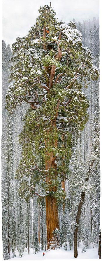
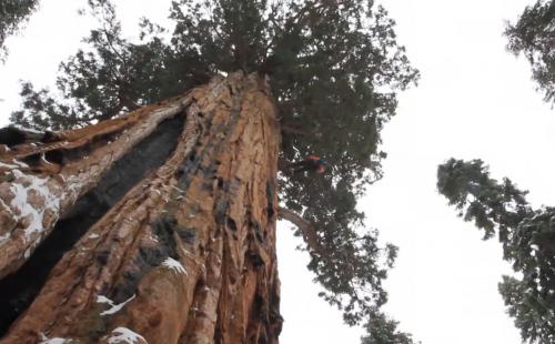
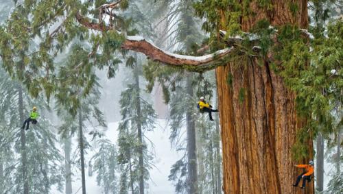
“The world’s second-largest known tree, the President, in Sequoia National Park is photographed by National Geographic magazine photographer Michael ‘Nick’ Nichols for the December 2012 issue.”

Seth Dixon‘s insight:

There is a beauty and magnificent in nature, both is the microscopic and delicate as well as the grand and powerful.  The biosphere’s diversity is a great part of it’s allure that keeps geographers exploring for to understand the mysteries on our planet.  This incredible image at the end of this project really is stunning.  

Tags: biogeography, environmentecology, historical, California.

See on www.youtube.com

Sequoia

President1 President

Globalization and the Textile Industry

“On the 100th anniversary of the Triangle Shirtwaist Factory Fire, little has changed in the global sweatshop economy. Workers are again trapped and burned to death behind locked exit gates.”

Seth Dixon‘s insight:

One of the first industries to be impacted by what is today called globalization was the textile industry and the successive waves of globalization continue to alter the geography of the textile industry.  This video shows how historical problems in the U.S. textile industry are seen today in countries such as Bangladesh as does this interactive featureThe following paragraph is from a Geography News Network podcast / article that Julie Dixon and I co-authored for Maps101 about the Bangladeshi garment industry: 

Many developing countries with the majority of their laborers working in agriculture welcome outsourced labor from the West. This is seen as a way to nurture industrialization, even if it is on the terms of trans-national corporations. Countless workers seek employment in textile factories simply because low pay is still an entry into the cash economy and it is one of the few jobs rural migrants can find when they first enter the big city. In such locations, Western labor, construction, and environmental standards are not priorities because the population’s basic needs haven’t been met, so the responsibility falls to the global companies—but their aim is to cut costs as much as possible to remain competitive.  From its emergence in textiles back in the late 1970’s, Bangladesh in 2013 made $19 billion in the export-oriented, ready-made garment industry, employing 4 million workers, most of whom are women. 

Listen to more of this Geography News Network podcast or read it here.

Tags: Bangladesh, poverty, development, economic, globalization, industry, labor.

See on www.youtube.com

20140407_94_bangladesh

The Science behind Google Earth

See on Scoop.itGeography Education

“Google is using a new technology to automatically generate  3D buildings from 45-degree angle aerial photography made by overlapping passes of aircraft.  The aerial photos are combined to create 3D models.”

Seth Dixon‘s insight:

Some of the nuts and bolts behind Google Earth might be difficult to replicate in the computer lab, but it is critical to conceptually understand how geospatial data is used today.  This series of images shows how important remote sensing is for our modern digital mapping platforms.  

Tags: cartography, visualization, mappingremote sensing, google.

See on worldcadaccess.typepad.com

Why It’s a Big Deal That Half of the Great Lakes Are Still Covered in Ice

See on Scoop.itGeography Education

“More than 200 million tons of cargo, mostly iron ore, coal, and grain, travel across the Great Lakes throughout the year. Even a little ice can make a big dent on this total. Only three shipments of coal were loaded up during March – 69 percent less, by volume, than last year.  A sluggish start to the shipping season is just one of the cascading effects of the Midwest’s cold and icy winter. Some are good, and will allow the region to recover from years of historically low water levels. Others, like this delayed shipping season, less so.”

See on www.theatlanticcities.com

Can You Identify These Cities From Their Light Signatures?

See on Scoop.itGeography Education

“The light that a city emits is like its glowing fingerprint. From the orderly grid of Manhattan, to the sprawling, snaking streets of Milan, to the bright contrast of Kuwait’s ring-roads, each city leaves its own pattern of tiny glowing dots. See if you can ID these cities based on the way they shine.”

Seth Dixon‘s insight:

This short quiz of 16 cities combines several analytic components of geography that you won’t see in more standard map quizzes for regional geography;  this draws on some similar skills similar to the map quiz that was based on identifying the city based on Starbucks locations.  Some recognition of local spatial patterns from previous map analysis can make this quiz easier but there are still some cities that you haven’t ever looked at from space before.  Things to consider as you attempt this quiz:  Which of the four possible selections can you rule out out?  What enabled you to eliminate those selections (e.g.-coastal, scale, size, grid pattern, transportation systems, density, etc.)?  What does to layout of the city tell us about the planning and historical origins of the city?  Is there one urban model that best helps us explain the configuration of this city?     

Tags: urbanmodels, planning, density, urbanism, unit 7 citiestrivia.

See on nautil.us

Largest glacier calving ever filmed

See on Scoop.itGeography Education


“On May 28, 2008, Adam LeWinter and Director Jeff Orlowski filmed a historic breakup at the Ilulissat Glacier in Western Greenland. The calving event lasted for 75 minutes and the glacier retreated a full mile across a calving face three miles wide. The height of the ice is about 3,000 feet, 300-400 feet above water and the rest below water.”

Tags: physical, geomorphology, landforms, erosion, climate change, Greenland.

See on www.youtube.com

Quebec Voters Say ‘Non’ to Separatists

See on Scoop.itGeography Education

“Quebec voters gave a resounding no to the prospects of holding a third referendum on independence from Canada, handing the main separatist party handing the main separatist party in the French-speaking province one of its worst electoral defeats ever.”  

Quebec, which is 80 percent French-speaking, has plenty of autonomy already. The province of 8.1 million sets its own income tax, has its own immigration policy favoring French speakers, and has legislation prioritizing French over English.  But many Quebecois have long dreamed of an independent Quebec, as they at times haven’t felt respected and have worried about the survival of their language in English-speaking North America.

TagsCanadapolitical, conflict, devolution.

See on www.nbcnews.com

California’s Drought

See on Scoop.itGeography Education

“California has had three consecutive years of below average rainfall and most reservoirs are far below their designed capacity; for a state with a growing population with limited water resources this is alarming news that has many politicians, officials and residents worried. This winter was especially mild; nice for bragging to friend back East about how gorgeous the weather is during a polar vortex spell, but horrible for the snow pack and accumulation.”

Seth Dixon‘s insight:

Most of California’s water originates for the snow pack in Western mountains ranges so this drought is expected to get worse this summer. The major urban areas have limited local water resources so they draw water from large area to bring in sufficient water for these burgeoning metropolitan regions.

20140408_CA_trd

Questions to Consider: What are some reasons (both from human and physical geography) for this severe drought? What can be done in the short-term to lessen the problem? What can be done to make California’s water situation better for the next 50 years?

Tags: physical, weather and climate, consumptionCaliforniaLos Angeles, water, environment, resources, environment dependurban ecology.

See on geographyeducation.org

LA water

New York City’s Disappearing Mom-and-Pop Storefronts

See on Scoop.itGeography Education

unknown-white.jpg__1072x0_q85_upscale

Two photographers set out to see what happened to small family businesses in New York City in a decade.

Seth Dixon‘s insight:

The cultural landscapes of neighborhoods can change quickly as larger global economic forces restructure the places.  This is a great gallery of photos from the Smithsonian to document these changes in New York City.  Many mourn the passing of what once was as the landscape continues to be made and remade but subsequent generations.

Tags: culture, landscape, NYCeconomic, urban place, neighborhood.

See on www.smithsonian.com


Blog at WordPress.com.

Up ↑