Search

GEOGRAPHY EDUCATION

Supporting geography educators everywhere with current digital resources.

Category

Uncategorized

Aerospace manufacturing takes off in South

See on Scoop.itGeography Education

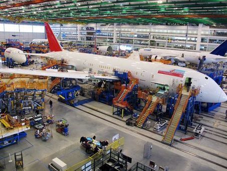
Region attracting some of the biggest names in aviation, including Boeing and Airbus.

The South is home to auto giants Mercedes-Benz, Volkswagen and Nissan Motor Co. It is increasingly attracting some of the biggest names in aviation, including Boeing Co. in South Carolina, Airbus in Alabama, Gulfstream Aerospace Corp. in Georgia and GE Aviation in North Carolina.

Aerospace companies are taking a cue from the auto industry and moving their manufacturing operations to Southern states. The region’s lower costs, generous state incentive packages and right-to-work laws that make it hard for unions to organize are motivating these companies to choose the South.

See on www.usatoday.com

If the Earth Stood Still

See on Scoop.itGeography Education

“The following is not a futuristic scenario. It is not science fiction. It is a demonstration of the results of an extremely unlikely, yet intellectually fascinating query: What would happen if the earth stopped spinning?  ArcGIS was used to perform complex raster analysis and volumetric computations and generate maps that visualize these results.

Seth Dixon‘s insight:

I love a good “what if?” question and this one (including the GIS model-based analysis) is fascinating. 

See on www.esri.com

American Makeover: SPRAWLANTA

See on Scoop.itGeography Education

“American Makeover is a web series on new urbanism, the antidote to sprawl.”

Seth Dixon‘s insight:

American Makeover only produced two segments in the series, but they are excellent examples that show the planning ethos of new urbanism.  In this episode, they lay out the argument against urban sprawl.  In Episode 2, they show the ideas that guided the planning of Seaside, Florida.  For a map of some of my favorite place based videos, which will include these, click here.     

tags: suburbs, transportation, planning, sprawlurban, land use, unit 7 cities

See on www.youtube.com

The Most And Least Sprawling Cities In America

See on Scoop.itGeography Education

“Tracking changes in the shape of American cities over 10 years reveals which cities pack the most into a small space, but don’t worry, sprawlers: Los Angeles shows you can change your fate.”


Today’s nearly 314 million U.S. residents will expand to 401 million in less than 40 years. Wherever you fall on the cultural spectrum between country and city mouse, the fact remains that we simply won’t be able to use up resources the way we do now in sprawling suburbs shaped by car culture.

Tags: density, sustainability, housing, urban, planning, unit 7 cities

See on www.fastcoexist.com

In Pictures: Crackdown in Brazil’s favelas

See on Scoop.itGeography Education

The Brazilian government’s ‘pacification’ initiative has led to drug busts and shootouts in Rio’s favelas.

Just a few months before Rio de Janeiro welcomes visitors for the World Cup, and two years before it hosts the Olympics, security within the city remains a major issue.  The government currently promotes the policy of “pacification”, where security forces engage in raids, drug busts, and even gunfights with suspected gang members. This pacification policy is supposed to pave the way for the development of long-neglected favelas in Rio, Brazil’s second-biggest city and home to 11 million people.  However, many of the favelas remain in the hands of an army of drug dealers and criminals who are not willing to step down or be pacified.

Seth Dixon‘s insight:

See on www.aljazeera.com

Earthquakes in the Classroom

See on Scoop.itGeography Education


“An 8.2-magnitude earthquake struck off the coast of northern Chile, generating a local tsunami.  The USGS reported the earthquake was centered 95 km (59 miles) northwest of Iquique at a depth of 20.1km (12.5 miles).  This video gives the context for this type of earthquake.”

Seth Dixon‘s insight:

I woke up this morning to news of a large earthquake in Chile (security camera video footage).  IRIS (Incorporated Research Institutions for Seismology) creates teaching resources for teachers who want to use the current events such as yesterdays’ earthquake in Chile as an opportunity to discuss earth’s physical systems and how they impact humanity.  They’ve produces slides, animations and PDFs for classroom use all while you were sleeping last night.  


Tags: visualization, disasters, physical, Chile.

See on www.youtube.com

Love ’em or hate ’em – Britain’s rocky relationship with the EU

See on Scoop.itGeography Education

“The United Kingdom’s relationship with the EU – or, in political parlance, ‘Europe’ – has long been one of the most divisive, emotive issues in British politics.”


Seth Dixon‘s insight:

The beginnings of the European Union are rooted in the aftermath of WW II, with Europe exhausted from war many politicians wanted to unite European countries in a way that would make war with each other impossible.  The United Kingdom, though has had a complicated with the EU, sometimes (and for certain issues) wanting greater European integration to strengthen their regional position and at other times have resisted regional collaboration for fear of losing national autonomy.  This is very over-generalized, but this BBC article gives a nice historical perspective on the rocky relationship of between the two.  


Tags: Europe, supranationalism, currency, economichistorical, sovereignty, UK.

See on www.bbc.com

New York Public Library Puts 20,000 Hi-Res Maps Online

See on Scoop.itGeography Education

“When I was a kid, my father brought home from I know not where an enormous collection of National Geographic magazines spanning the years 1917 to 1985. I found, tucked in almost every issue, one of the magazine’s gorgeous maps—of the Moon, St. Petersburg, the Himalayas, Eastern Europe’s ever-shifting boundaries. I became a cartography enthusiast and geographical sponge, poring over them for years just for the sheer enjoyment of it, a pleasure that remains with me today.  Whether you’re like me and simply love the imaginative exercise of tracing a map’s lines and contours and absorbing information, or you love to do that and you get paid for it, you’ll find innumerable ways to spend your time on the new Open Access Maps project at the New York Public Library.”

See on www.openculture.com

Logging and Mudslides

See on Scoop.itGeography Education

In recent decades the state allowed logging — with restrictions — on the plateau above the Snohomish County hillside that collapsed in last weekend’s deadly mudslide.

Seth Dixon‘s insight:

There are several reasons for mudslides–some are purely a result of physical geography and others are related land use patterns.  This last week’s mudslide in Washington state was a combination of the two and although this impacts one place (see on map), it is a good teaching moment to discuss the environmental impacts of land use patterns and resource extraction projects.  As seen in this interactive, the river was cutting at the base of the hill, while loggers were clear-cutting at the top of the mountain.  Trees help prevent erosion as the roots hold the soil in place–a critical piece to the puzzle in a very rainy climate.  With $1 million worth of timber on the slope, logging companies persisted despite objections from the Department of Natural Resources and some restrictions (but in hindsight, those restrictions clearly were not enough).

View the impact in ArcGIS online: Before and After Swipe, LiDAR I and II, and Imagery.

Questions to Consider: Other than economic worth, what other ways are there to value and evaluate the environment?  How could this landscape have been protected and managed better or was this mudslide inevitable?   

Tagspolitical ecology, resources, environment, environment modify, industry, physical, geomorphology, erosion, landforms.

See on seattletimes.com

Mudslide

Create a free website or blog at WordPress.com.

Up ↑