See on xkcd.com

The Atlas of True Names reveals the etymological roots, or original meanings,
of the familiar terms on today’s maps of the World, Europe, the British Isles and the United States.
For instance, where you would normally expect to see the Sahara indicated,
the Atlas gives you “The Tawny One”, derived from Arab. es-sahra “the fawn coloured, desert”.
Seth Dixon‘s insight:
This is a fun set of maps that forces us to reexamine the historical linguistic roots of place names. Many toponyms have a complicated histories so the actual root of the name is not always a single straightforward translation as shown in these maps. As you explore these maps, most readers will find something the they would dispute, correct, or want to see contextualized more but all in all, it is a fun set of maps.
Tags: language, mapping, art, cartography, toponyms, historical.
See on www.kalimedia.com

“Many of us tend to think of Antarctica as a sheet of solid snow and ice. But, in contrast with its peer to the north, the southern pole’s ice sheet lies atop a rocky continent. What are its features, its mountains and valleys, plains and coastlines?
A new dataset from the British Antarctic Survey provides the most detailed map ever of the bedrock below, information scientists hope will enable them to better model the affects of climate change on the ice, whose melting will have an impact on climate the world over.”
Seth Dixon‘s insight:
This video sheds some light on explorations to uncover truths about one of the most remote places on Earth.
Tags: Antarctica, water, physical, remote sensing, geospatial.
See on www.theatlantic.com
Seth Dixon‘s insight:
If you haven’t discovered CGP Grey yet, his YouTube channel is a veritable fountain of geographic tidbits. His distinctive style helps to contextualizes some of the more odd and complicated parts of Earth’s borders. If you want another example, watch Bizarre Borders, part 1 which focuses on countries within countries and single-neighbor countries.
See on www.youtube.com

New geologic map helps scientists understand ancient volcano’s roots and contemporary rock falls.
Seth Dixon‘s insight:
On a personal note, my very first globe and National Geographic Magazines were given to me by my grandparents who noticed I had an affinity for all things geographic. They lived just outside Yosemite Park and they made sure I explored it frequently while I was growing up so I have a soft spot for this particular national park. My grandfather informed me that El Capitan was the largest rock on Earth and my skeptical 3rd grade mind replied, “Is that a fact or an opinion?” Informal geographic education had a greater impact on my educational path than the formal K-12 curriculum. Without those simple nudges, I doubt I would be a geographer today.
Tags: California, physical, geomorphology, erosion, landforms.
See on news.nationalgeographic.com

Rising waters spilled onto flood plains and into cities across Germany. Central Europe has endured its worst flooding since medieval times.
Seth Dixon‘s insight:
If you having been following the news lately, central European countries such as Germany and Poland are experiencing major flooding right now. Compare this image above to one where the Elbe isn’t flooding and you’ll quickly be able to visualize extent of the flooding.
Tags: Germany, remote sensing,disasters, environment, geospatial.
See on earthobservatory.nasa.gov
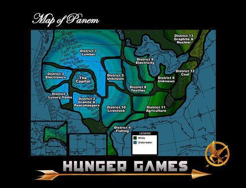
From The Hunger Games trilogy: different perspectives on the country of Panem.
Seth Dixon‘s insight:
This imagined geography in the Hunger Games is loosely based on what a post-apocalyptic North America (that’s partially submerged) might look like. This is but one of the many maps collected on this pinterest board that I found through GISetc.
See on pinterest.com
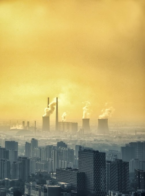
Seth Dixon‘s insight:
We’ve all heard stories about the horrible air quality in Beijing (especially during the 2008 Olympics). Here’s a picture of Beijing by Tom Anderson that I find riveting. The skies are horribly polluted but this image shows two competing cities that are at odds with each other; on the one hand the cosmopolitan capital that is sophisticated and technologically advanced. On the other side we see the industrial city that is recklessly producing copious amounts of consumer products with little regard for the environment or worker safety. These are both true reflections of China in the 21st century and the tension between the two will be one of China’s great issues in the foreseeable future.
Tags: pollution, planning, development, economic, megacities, East Asia, industry.
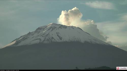
Seth Dixon‘s insight:
This image is from June 11, 2013, but if you click on the link you will see an image of Popocatépetl that is refreshed every minute. This massive volcano looms over Mexico City and plays a key role in the mythology of the city. The images are taken from a relatively new station in Tochimilco (clouds or intense weather might occasionally limit the visibility of the volcano).
See on www.cenapred.unam.mx


