Search

GEOGRAPHY EDUCATION

Supporting geography educators everywhere with current digital resources.

Category

Uncategorized

Smartphones as geospatial tools

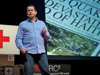
The disastrous earthquake in Haiti taught humanitarian groups an unexpected lesson: the power of mobile devices to coordinate, inform, and guide relief efforts.

Tags: technology, disasters, Haiti, TED.

Seth Dixon, Ph.D.‘s insight:

We are only beginning to see the applications of smart phones to improve peoples lives.  In this TED talk, Paul Conneally explores some of the possibilities (citizen mapping, crowd-sourced disaster recovery, etc.) that is just sitting in the palm of our collective hands. 

See on www.ted.com

NOVA: Earth From Space

Detailed satellite images reveal the web of connections that sustain life on Earth.

Seth Dixon, Ph.D.‘s insight:

“Earth From Space is a groundbreaking two-hour special that reveals a spectacular new space-based vision of our planet. Produced in extensive consultation with NASA scientists, NOVA takes data from earth-observing satellites and transforms it into dazzling visual sequences, each one exposing the intricate and surprising web of forces that sustains life on earth.”

This documentary shows something interesting for the physical geographer, human geographers, and geospatial technology specialists.  In other words, this touches on just about all things geographic (with cool images!).  The overarching theme is that so many things in this world that we wouldn’t imagine are actually interconnected with excellent examples.

Tags: remote sensing, geospatial, unit 1 Geoprinciples, physical.

See on www.pbs.org

earth-from-space-vi

Map: Most Popular Baby Names By State, Or, The Land Of The Sophia And The Home Of The Mason

Check out this funny map of the most popular baby names by state, only on NickMom.com!

See on www.nickmom.com

Tea-plucking machines threaten Assam livelihoods

Tea plucking machines are threatening the livelihoods of tea pickers in the Indian state of Assam, reports Mark Tully.

Seth Dixon, Ph.D.‘s insight:

This is yet another example of the uneven impacts of globalization. 

See on www.bbc.co.uk

Megacities Reflect Growing Urbanization Trend

Read the Transcript: http://to.pbs.org/b6sR86 The capital of the South Asian country Bangladesh, Dhaka, has a population that is booming. However, it stands …

Seth Dixon, Ph.D.‘s insight:

This is a great introduction to the demographic explosion of the slums within megacities.  This is applicable to many themes within geography.   

Tags: Bangladesh, water, pollution, poverty, squatter, planning, density, South Asia, development, economic, megacities.

See on www.youtube.com

A Crazy But Rational Solution To Our Electoral College Problem

On three different occasions, the candidate with the most votes didn’t become President of the United States. We call this “The Electoral College Problem.” Here a solution. Simple. Mathematical. Rational.

Seth Dixon, Ph.D.‘s insight:

As a disclaimer, I’m not endorsing the removal of all current state borders, but I think that this is a great thought exercise that involves some serious spatial thinking and geography knowledge to create this map (or even to critique and discuss it).  This map represents an attempt to restructure the states so that each state would have equal value in the electoral college with roughly equal populations (county borders remained firm).  What about the physical and human geography would make some of these “states” better (or worse) than the current configuration of the 50 states? How would this ‘redistricting’ impact your local region? 

Tags: political, gerrymandering, mapping, unit 4 political.

See on www.npr.org

The Permanence of Geography

The current rise or durability of the economies of the Global South do not signal that economic geography does not matter, but that current investment has simply shifted.

Seth Dixon, Ph.D.‘s insight:

In an era where globalization has rendered distances a minor barrier to diffusion, some have erroneously concluded that geography is no longer relevant to economic development and urban planning.  Nothing could be farther from the truth, but that doesn’t mean that the ‘old rules’ of space and place aren’t be re-written.  This is a nice article that discusses the continued importance of spatial thinking and geography for urban planning.

Tags: urban, planning economic, urbanism, globalization, unit 7 cities.

See on sustainablecitiescollective.com

When an asteroid gets too close : ImaGeo

Seth Dixon, Ph.D.‘s insight:

Many of you have seen the YouTube video of the meteor in Russia this week (wondered why so many Russians have cameras on their dashboards?).  This show the geologic impact of the largest meteors.  Pictured above is Meteor Crater in Arizona.   

See on blogs.discovermagazine.com

How are satellite images different from photographs?

“Satellites acquire images in black and white, so how is it possible to create the beautiful color images that we see on television, in magazines, and on the internet? Computers provide us with the answer.

Images created using different bands (or wavelengths) have different contrast (light and dark areas). Computers make it possible to assign ‘false color’ to these black and white images. The three primary colors of light are red, green, and blue. Computer screens can display an image in three different bands at a time, by using a different primary color for each band. When we combine these three images we get a ‘false color image.’

Find tutorials and links to free compositing programs here.”

Seth Dixon, Ph.D.‘s insight:

See on landsat.gsfc.nasa.gov

Blog at WordPress.com.

Up ↑