Search

GEOGRAPHY EDUCATION

Supporting geography educators everywhere with current digital resources.

Category

Uncategorized

Disputed Isles

Competing territorial claims have led to maritime disputes off the coast of Asia. See a map of the islands at issue.

This is an nice interactive map that allows the reader to explore current geopolitical conflicts that are about controlling islands.  This is an good source to use when introducing Exclusive Economic Zones, which is often the key strategic importance of small, lightly populated islands.

Tags: EastAsia, SouthEastAsia, political, unit 4 political, territoriality, autonomy, conflict, economic.

See on online.wsj.com

An Annotated Map of Today’s Protests and of the ‘Muslim World’

The violent backlash against the American film is taking place in Muslim societies, but it doesn’t seem to correlate with Islam’s reach.

This is a good reminder that the generalizing about “all Muslims” is as inaccurate as generalization about “all Christians” or any other group.  The world and people are much more nuanced than that. 

Tags: MiddleEast, Islam, conflict.

See on www.theatlantic.com

How The USA Expanded In One Mesmerizing Animated GIF

Amazing work from wikipedia, summarizing the evolution of the US formation, originally here: http://en.wikipedia.org/wiki/Territorial_evolution_of_the_United_States

Tags: USA, historical, visualization

See on edudemic.com

The Authoritative Map

In the Winnie the Pooh Movie “Pooh’s Grand Adventure,” the character Rabbit has absolute confidence in the printed word and especially the map.

Questions to ponder:  How much do we trust any given map?  How much should we trust a map (or the printed word)?  What makes a document reliable or unreliable?

Tags: mapping, perspective, K12, video.

See on www.youtube.com

On Israel’s system of segregated roads in the occupied Palestinian territories | Visualizing Palestine

Tags: MiddleEast, territoriality, transportation, borders, conflict, governance, political, unit 4 political

See on visualizingpalestine.org

The Lower Ninth Ward in New Orleans Gives New Meaning to ‘Urban Growth’

Since Katrina, the cartoonish pace of vegetation growth in the Lower Ninth Ward of New Orleans resembles something out of a Chia Pet commercial.

The ecosystem is reclaiming parts of New Orleans that have been physically or economically abandoned.  This is part elevation, climate and ecosystem; but it is also about urban land uses, disinvestment and socioeconomics.

Tags: urban ecology, environment, ecology, urban, unit 7 cities, disasters.

See on www.nytimes.com

Bounces in GPS signals reveal snow depth

UNAVCO, a non-profit university-governed consortium, facilitates geoscience research and education using geodesy.

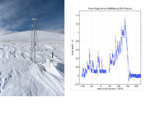
“Researchers at the University of Colorado Boulder and the University Corporation for Atmospheric Research have been using what is typically considered an error in the GPS signal to measure snow depth around GPS receivers. A GPS receiver records both direct and reflected signals from a satellite. A reflected signal bounces off of whatever is around the GPS station before being recorded, and therefore can contain information about the ground surface close to the station.

Traditionally snow depth has been measured by hand. In other words, someone had to go out with a measuring stick to whatever location they were interested in.  GPS snow depth measurements solve both of these problems: once a GPS unit is installed, it can function on its own throughout the winter, and will make a measurement every two hours, which is then averaged for a daily position, or in this case, snow depth.”

Tags: GPS, climatechange, water, technology,

See on unavco.org

GPS or Maps?

We are a society that is reliant on modern navigational devices.  This is an interesting article that argues for keeping modern equipment, but asks us not to eliminate older technologies in our haste to embrace the shiny and new.  “Technology as great as it is should never be a replacement for skills, but a tool used to assist you.”

Tags: GPS, technology, spatial.

See on www.spirit917fm.com

NASA animation of temperature data from 1880-2011

Tags: video, environmentvisualization, climatechange, environment modify.

See on www.youtube.com

Blog at WordPress.com.

Up ↑