Search

GEOGRAPHY EDUCATION

Supporting geography educators everywhere with current digital resources.

Category

Uncategorized

Size and Politics

See on Scoop.itGeography Education

Revisiting an Austrian academic’s call for smaller borders.

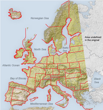
This New York Times article, entitled “Kohr Principles” has excellent material for students to think about the spatial organization of political interactions.  Leopold Kohr argued that size matters–and unlike most that argue for the same, he argued that political entities must not be too large.  In the map above, Kohr envisioned a Europe without countries large enough to dream of world domination.  So, how does a country’s size shape its politics?  Is there an ideal size for internal unity and external security?

See on opinionator.blogs.nytimes.com

Geography Education Wiki

See on Scoop.itGeography Education

Would you be interested in a geography education wiki project?  Daniel Whalen has set up an AP Human Geography Wiki with great resources to use, but also a platform your you to collaboratively produce.  Check it out!

See on gphscrossroads.wetpaint.com

Geography Education Professional Development

See on Scoop.itGeography Education

On June 4, 2012 there was a series of geography education professional development workshops in Cincinnati, Ohio.  One of these workshops focused on how to use educational technologies more effectively in the classroom.  The resources at this workshop are all archived on this site managed by one of Canada’s finest, David Joiner.  


See on kilby.sac.on.ca

Learning about Water with ArcGIS Online

See on Scoop.itGeography Education

ESRI is the world leader in GIS (geographic information system) technology. This site features free GIS software, online mapping, online training, demos, data, software and service information, user scripts, and more. 


This learning module includes activities that analyze water (oceans, rivers, watersheds, wetlands, etc.) within an explicitly spatial context.  As the author of the module, Joseph Kerski states: “Water is a spatial subject: It easily moves among its solid, liquid, or gas phases on our planet. It flows through oceans, rivers, wetlands, glaciers, and through the hydrologic cycle at different rates.  Thus, the geographic perspective and GIS are useful to understanding water from local to global scales.  These activity use ArcGIS Online, a Web-based Geographic Information System (GIS).  No previous experience with GIS is necessary.”

See on edcommunity.esri.com

AP Human Geography – Mrs. Watson’s Class

See on Scoop.itGeography Education

Mrs. Watson’s Class, online resource for Lawton Chiles High School, AP Human Geography, World History, and History Fair.


This is an excellent teacher website that systematically explains course goals and provides auxiliary resources. 

See on www.mrswatsonsclass.com

Religion and Demographics

See on Scoop.itGeography Education

http://www.ted.com Hans Rosling had a question: Do some religions have a higher birth rate than others — and how does this affect global population growth? …


What are the connections between religion and demographics?  How does this impact population structure in a particular country?  I found this video from Jeff Martin’s fabulous website; Check it out!  http://www.martinsaphug.com/  

See on www.youtube.com

Poverty’s Poster Child

See on Scoop.itGeography Education

Some of the toughest and most persistent poverty in America exists on Indian reservations, like Pine Ridge in South Dakota. But it’s not hopeless.


One need not leave the United States to find areas of poverty akin to less developed countries.  Reservations for Native Americans often fit that description.  

See on www.nytimes.com

Map of Life

See on Scoop.itGeography Education

By bringing together all types of information about species distributions, providing model-based integration, and providing a system for users to build upon our knowledge, the Map of Life project hopes to support our community in understanding and…


This site stores an online database of the spatial distribution of over 25,000 species, and with GIS layer tools, allows users to map biogeographical patterns.  If you want to teach geography in collaboration with a biology project, this is the perfect tool.  For a press release about the project funded by Yale, UC Boulder, NASA, WWF and others, see: http://green.blogs.nytimes.com/2012/05/16/filling-in-the-blanks-on-a-map-of-life/ 

See on www.mappinglife.org

Maps of the Future

See on Scoop.itGeography Education

A 1989 prediction about portable GPS devices was right on the money…


As technology continues to speed ahead, how we interact with maps will keep evolving.  This is a thoughtful blog post that spectulates about the future of mapping. 

See on blogs.smithsonianmag.com

Create a free website or blog at WordPress.com.

Up ↑