Search

GEOGRAPHY EDUCATION

Supporting geography educators everywhere with current digital resources.

Category

Uncategorized

Population Growth in Metropolitan America Since 1980

Via Scoop.itGeography Education

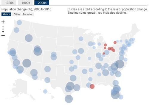
The twists and turns of metropolitan population growth are reviewed in William Frey’s examination of recently released Census Bureau data separating the bubble and bust years of the past decade.


Key urban demographic changes from 1980-2010:

–Metropolitan growth in both the Sun Belt and Snow Belt tapered in the 2000s, after accelerating in the 1990s.

–Growth slowed considerably during the latter part of the 2000s, especially in “bubble economy” metropolitan areas.

–Suburbs continued to grow more rapidly than cities in the 2000s, but growth rates for both types of places declined from their 1990s levels.

–Exurban and outer suburban counties experienced a population boom and bust in the 2000s.

–Hispanic dispersion to “new destination” metropolitan areas and suburbs dropped sharply in the late 2000s.

Via www.brookings.edu

Why the Global Warming Skeptics Are Wrong

Via Scoop.itGeography Education

“The threat of climate change is an increasingly important environmental issue for the globe. Because the economic questions involved have received relatively little attention, I have been writing a nontechnical book for people who would like to see how market-based approaches could be used to formulate policy on climate change. When I showed an early draft to colleagues, their response was that I had left out the arguments of skeptics about climate change, and I accordingly addressed this at length.” 


This is an excellent summary of the scientific basis for anthropogenic climate change as a scientific reality.  It addresses the concrens of climate change skeptics, point by point and notes flaws in the logic, data or reasoning. 

Via www.nybooks.com

Rolling tobacco for a living

Via Scoop.itGeography Education

Sagira Ansari is among the thousands of children working in hazardous industries that are crucial to the Indian economy.


This gallery of 9 images with captions is an excellent lens for showing life in South Asia and child labor issues. 

Via www.washingtonpost.com

Interactive Map: Economic Stress Index

Via Scoop.itGeography Education

This is a great interactive feature focusing on the differential impacts of the economic downturn on particular places.  You can zoom in, see county-level data, and slide the time bar at the bottom to get spatiotemporal data.    

Via hosted.ap.org

Mapping the Anthropocene

Via Scoop.itGeography Education

As follow-up to an earlier post about how we have enter the age of the Anthropocene, this stunning map is a fantastic visual representation of the forces that merit the dawning of a new geologic age.  This map depicts the lights at night, major roads, railways power lines, oversea cables, airline routes and shipping lanes.  It also expands the areas according to population size.  For more on the production of this map, see the Globaia website.

Spotted on Living GeographyVia www.viewsoftheworld.net

Tajik Remittances From Russia up 30%

Via Scoop.itGeography Education

Tajik migrants working in Russia sent to $2.96 billion in remittances to their families in Tajikistan in 2011, over 30 percent more than the previous year, National Bank Deputy Chairman Malokhat Kholikzoda said on Thursday.   The higher the national dependence on remittances, the worse off the country is essentially at being economically independent and viable. 
Via en.ria.ru

Will There Be a Central Asian Spring?

Via Scoop.itGeography Education

Kazakhstan may not be ripe for revolution, but the West is making the same mistakes it made in the Arab world.
Via www.foreignpolicy.com

Sporcle: Geography Quizzes

Via Scoop.itGeography Education

The best trivia games and quizzes on the internet.   With over 800 games and quizzes on this site with varying skill levels, there is something for everyone here.  Some are standard quizzes such as “European Countries” or “Asian capital cities.”  However some get you to reorganize your global knowledge in ways you’ve never considered.  For example, What is the most populous city in the world for each given time zone (not that easy right)?   
Via www.sporcle.com

Mercator’s 500th birthday: ArcGIS Resource Center

Via Scoop.itGeography Education

While the web mapping world still relies too much on the Mercator projection for my preference, it is a testament to the enduring impact that his ideas have had in literally shaping our World.  When discussing map projections, this article has some valuable materials. 
Via blogs.esri.com

Create a free website or blog at WordPress.com.

Up ↑