Search

GEOGRAPHY EDUCATION

Supporting geography educators everywhere with current digital resources.

Category

Uncategorized

What Did Chicago Look Like Before the Great Fire?

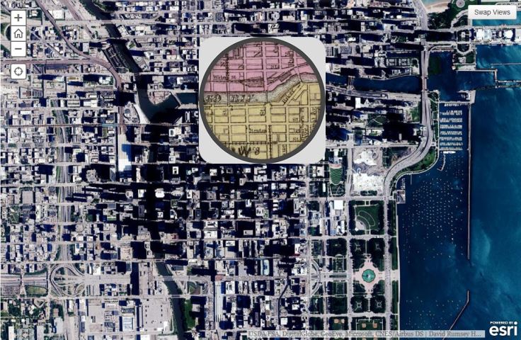
This 1868 pocket map of Chicago shows the city in full-blown expansion, a mere 3 years before the infamous blaze

Source: www.smithsonianmag.com

This is an ESRI interactive web app that uses the ‘spyglass’ feature.  Chicago is displaced during a economic boom period as the U.S. was expanding westward.  Where where the railroads located then?  Why have some of them vanished today?  Notice anything curious about the coastline along Lake Michigan?  Follow this link to see similar interactives of other major U.S. cities.

Tags: Chicago, historical

Earth is Home to 3.02 Trillion Trees

“A new census that shows that Earth is host to a staggering 3.02 trillion trees — more than scientists expected.The most recent estimate only counted 400 billion trees, reports Rachel Ehrenberg. Because prior studies used satellite technology alone instead of including data from on-the-ground tree density studies, writes Ehrenberg, they missed the mark. They also estimate that since human civilization began, 45.8 percent of all trees been lost.”

Source: www.smithsonianmag.com

I love satellite data, but ground-truthing is critical to so many research projects. 

Tagsremote sensing, conservation, physical, biogeography, environment, resources.

Canada’s secret plan to invade the U.S. (and vice versa)

After World War I, Canada drew up classified plans to invade the U.S. Meanwhile, the U.S. had its own secret plot to create the “United States of North America.”

Source: www.mprnews.org

I never knew 1921 to 1930 was such a frosty time in Canadian-U.S. relations that BOTH sides drew up possible invasion plans.  Judging by these amazing arrows, these plans were never seriously about to be executed, but it is a good reminder that geopolitical partnerships (and rivalries) are ever-changing.  Today, if there are border tensions between these two allies, it might just center around the Arctic as it’s geopolitical importance is rising.  Also, I did enjoy the 1920s reference that Americans simply assumed that Canada (once the British Empire was dismantled) would naturally be absorbed by the United States. 

TagsCanada, geopoliticspolitical, war.

The Geographically Uneven Coverage of Wikipedia

This map points out the highly uneven spatial distribution of (geotagged) Wikipedia articles in 44 language versions of the encyclopaedia. Slightly more than half of the global total of 3,336,473 articles are about places, events and people inside the red circle on the map, occupying only about 2.5% of the world’s land area.

Source: geography.oii.ox.ac.uk

Crowdsourcing is a powerful way to leverage modern digital sharing capabilities, but it inherently going to lead to inequities in the reporting coverage.  Why are there so many geo-tagged Wikipedia articles in Europe and not as many elsewhere?  What factors account for these discrepancies? 

Tags: visualizationsocial media, mapping, culturetechnology, popular culture, Europe.

Where ‘speeding’ is legal: A map of maximum limits across the U.S.

An unconventional look at American roads, mapped by their speed limits.

The above map, from MetricMaps, illustrates that abrupt division using local speed limit data.  That map shows the maximum local speed limit for any local roads or highways in each Census block group in the U.S. The nationwide contrasts are striking, but so are the local ones: Zoom in to an individual city like Los Angeles, and the darker arteries effectively outline highways.

Source: www.washingtonpost.com

This map shows some stark contrast between urban and rural land use patterns–it also shows urban networks that are designed to compression time and space.   

Tags: transportation, planningspatial, scale, Time-Space Compression,.

Infographic: The Syrian conflict

Syria’s civil war has inflicted a humanitarian crisis, expansive exodus of the population and a severe death toll. New Internationalist presents the facts in this zoomable infograph.

Tags: infographic, Syriamigration, political, refugees.

Source: newint.org

Travel speeds in the U.S. in the 1800s

Maps from the 1932 Atlas of the Historical Geography of the United States put travel in the 1800s into perspective.

Source: www.mnn.com

This series of maps shows the great leaps and bounds that were made during the 19th century in transportation technology in the United States.  This impacted population settlement, economic interactions and functionally made the great distances seem smaller.  This is what many call the time-space compression; the friction of distance is diminished as communication and transportation technologies improve.  

Questions to Ponder: When someone says they live “10 minutes away,” what does that say about how we think about distance, transportation infrastructure and time?  How is geography still relevant in a world where distance appears to becoming less of a factor?  


Tags: transportation, modelsdiffusion, globalization, diffusion, time-space.

What happened when Portugal decriminalized drugs?

“For 20 years The Economist has led calls for a rethink on drug prohibition. This film looks at new approaches to drugs policy, from Portugal to Colorado. ‘Drugs: War or Store?’ kicks off our new ‘Global Compass’ series, examining novel approaches to policy problems.”

Tags: PortugalEurope, politicalpopular culture, narcotics.

Source: www.youtube.com

The distribution of narcotics impacts virtually every country in the world; there are incredibly divergent strategies on how to mitigate these problems that are a result of sophisticated distribution networks.  What is the best way to stop the flow of dangerous drugs and the illegal activities that accompany the drug trade?  If you were in charge, what strategies would you recommend? Are some solutions a better fit for the political and cultural climates of diverse places?

Teenage Girls Have Led Language Innovation for Centuries

They’ve been on the cutting edge of the English language since at least the 1500s

Source: www.smithsonianmag.com

Popular culture and those most closely tied to it are innovators. 


Tags: language, culturediffusion, popular culture.

Blog at WordPress.com.

Up ↑