Search

GEOGRAPHY EDUCATION

Supporting geography educators everywhere with current digital resources.

Category

Uncategorized

The Food Capitals of Instagram

Explore the popularity of some of the world’s favourite foods on Instagram. Discover Instagram’s capital of curry, which cities are big on burgers, and where pulled pork is most prolific.

Source: photoworld.com

I was talking to a good friend about the geographic distribution of poutine after watching the silliest YouTube video. (Montreal is famous for it’s poutine, but is in equally widespread throughout Quebec?  Canada?  Is there a core/domain/sphere areas to be mapped? These are the questions that plague geographers.).  True, this map has it’s limitations; Instagram hashtag data isn’t normalized so the biggest cities tend to pop out more easily, access/use of Instagram isn’t uniform, etc.  Still, what a great map to show some geographic applications of social media data.  This sort of map also nicely shows the spatial concepts of region, diffusion, concentration and distribution.  


Tags: visualizationsocial media, mapping, culturediffusion, popular culture, regions, food.

Tourists Vs Locals: Cities Based On Where People Take Photos

“Tourists and locals experience cities in strikingly different ways. To see just how different these two worlds are, have a look at the map of Washington D.C. above based on where people take photos. The red bits indicate photos taken by tourists, while the blue bits indicate photos taken by locals and the yellow bits might be either.”

Source: brilliantmaps.com

It amazes me how the same city can provide such diverse experiences to so many people.  Growing up in San Diego, going to the zoo was only our family’s radar when company was over and they wanted to “see San Diego.”  Their vision of the place, what is iconic and what is quintessentially symbolic of that place, was different from my own. 


Questions to Ponder: What are some other ways (besides local/tourist) that a place can be experienced by other groups?  How many of these 136 cities can you identify from these tourist/local patterns? 

Tagsmapping, social media, urban, placeculture, landscape, tourism

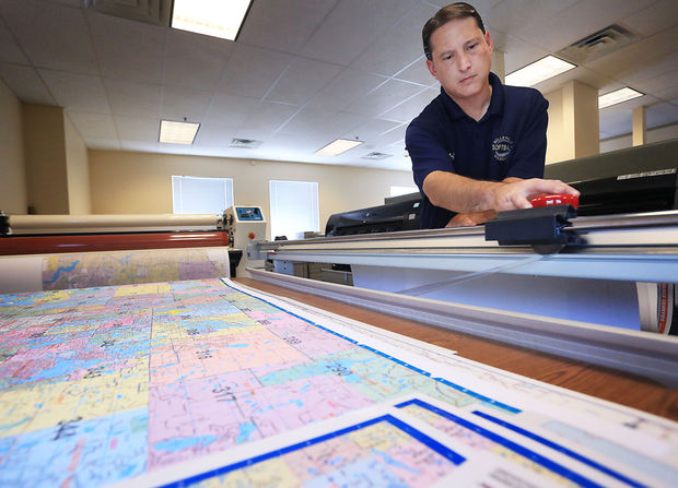
Paper maps still relevant even with computers, GPS

“The president and owner of Mapping Specialists, David Knipfer, said maps are more prevalent in society now than they’ve ever been, from turn-by-turn direction apps, to restaurant searches, to social networks that pinpoint users’ locations. Maps aren’t going away, but people are learning to use them in a different way, Knipfer said.”

Source: host.madison.com

Organizing APHG content

“Digital resources to strengthen the quality and quantity of geography education in classrooms the world over.”

Source: www.scoop.it

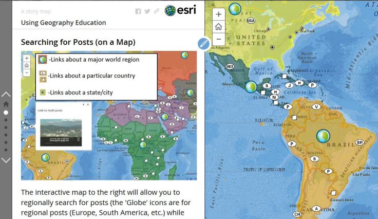
Since this site is updated daily and organized chronically, finding some of the best posts from the past can be difficult for someone new to the site.  Some of the posts are on current events and not as relevant several years after the fact, but I want to make it easier to find the older posts that are still relevant today more easily accessible.  I’ve organized some of more ‘evergreen’ posts by the AP Human Geography curriculum unit headings as well as ‘shortlist’ for each unit.  Additionally, this Story Map will also guide you on how to get more out of this website.         

  1. Geography: It’s Nature and Perspectives (shortlist)
  2. Population and Migration (shortlist)
  3. Cultural Patterns and Processes (shortlist)
  4. The Political Organization of Space (shortlist)
  5. Agriculture, Food Production and Rural Land Use (shortlist)
  6. Industrialization and Economic Development (shortlist)
  7. Cities and Urban Land Use (shortlist)

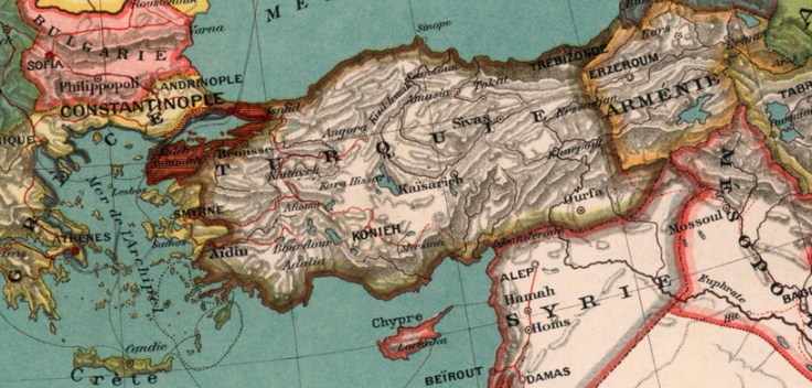
Forget Sykes-Picot. It’s the Treaty of Sèvres That Explains the Modern Middle East.

Ninety-five years ago today, European diplomats gathered at a porcelain factory in the Paris suburb of Sèvres and signed a treaty to remake the Middle East from the ashes of the Ottoman empire. The plan collapsed so quickly we barely remember it anymore, but the short-lived Treaty of Sèvres, no less than the endlessly discussed Sykes-Picot agreement, had consequences that can still be seen today. We might do well to consider a few of them as the anniversary of this forgotten treaty quietly passes by.

Tags: devolutionhistorical, political, states, borders, political, Turkey.

Source: foreignpolicy.com

Living in the Shadow of Industrial Farming

“The world eats cheap bacon at the expense of North Carolina’s rural poor.” 

Source: www.youtube.com

In a recent article by QZ (the video above comes from the same investigation), they explore the negative impacts of the pork industry.  People love their bacon memes, but forget about social and environmental impacts of an increased global trend towards higher pork consumption


Tags: food, agriculture, agribusiness, unit 5 agriculture, agricultural environment, environment, environment modify, pollution. 

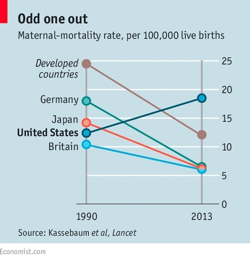
America’s most embarrassing statistic — and one effort to change it

Why is the US the only industrialized nation with a rising rate of maternal mortality? Supermodel-turned-maternal health advocate Christy Turlington Burns talks about her latest mission to raise awareness about maternal deaths.

99% of deaths related to pregnancy and childbirth occur in the developing world. The good news is that in most countries the rate of maternal mortality has been going down. The bad news is that in eight countries the rate is going up. The shocking news is that the United States is among them. It is the only industrialized country to have that dubious distinction. The rate has in fact been doubling in recent years.

Tag: mortality, developmentgender, statistics, USA.

Source: www.pri.org

How Maps Are Saving the World

Maps. They’ve been around longer than photographs. They’ve defined empires,guided explorers, told stories, and captured the imagination of many a hopeful traveler for years. While most appreciate the beauty and power of a good map, few recognize the dynamic and vital applications they have today.

Tags mapping, 201, edtech, cartography.

Source: news.nationalgeographic.com

Children and Space

“In just a few generations, we have tightly restricted American kids’ freedom to roam, play, and become self-sufficient. The percentage of children walking and bicycling to school has plummeted from almost 50 percent in 1969 to about 13 percent today. Although distance from school is often cited as the main barrier to walking and bicycling, many families still drive when schools are close to home. According to the Safe Routes to School National Partnership, driving accounts for about half of school trips between 1/4- and 1/2-mile long — which in most cases shouldn’t take kids much more than 10 minutes to walk.”

Source: vimeo.com

This is a controversial topic and I certainly don’t have all the answers. The free range parenting is a new to to our cultural conversations about parenting, but the ideas are anything but new. Most free range advocates want their children to have the rights to roam about their neighborhoods that others today would see as parental neglect. Many argue that as automobiles have become more prominent in urban design, it has come at the expense of children’s ability to be in public unsupervised (yes, children used to be encouraged to go out to play in the streets). Children don’t know their own neighborhoods as well anymore and this isn’t just about architecture and design. Culturally our communal notions of proper parenting and child safety have shifted in the United States, but they are also very different around the world.  


Questions to Ponder: How is parenting shaped by cultural norms? What are the spatial implications of changing parenting strategies? What are the factors that shape your opinion about the ‘proper’ range for kids to roam unsupervised?  

Tags: housing, placeneighborhood, perspective, cultural norms, culture, transportation, planningspatial.

Create a free website or blog at WordPress.com.

Up ↑