Search

GEOGRAPHY EDUCATION

Supporting geography educators everywhere with current digital resources.

Category

Uncategorized

Why South Carolina’s Confederate flag isn’t at half-staff after church shooting

The battle over a fraught symbol is resurrected.

Source: www.washingtonpost.com

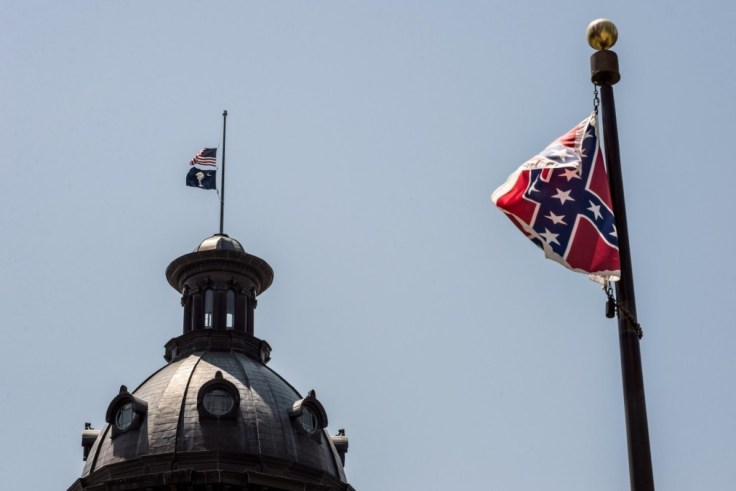
The AME church in Charleston S.C. was targeted in a racist-motivated terrorist attack this week.  Many racial issues have come to the fore in the wake of this attack.  Two flags were lowered more than 100 miles away in Columbia, the state’s capital, the one’s picture above flying on the dome of the state house.  Whether South Carolina politicians want to or not, the issue of the Confederate Battle Flag has resurfaced because as a sanctioned part of the cultural landscape, it’s symbolism is continually called into question.


Tags: raceconflict, racism, historical, the Southlandscape.

Temples and Human Sexuality

It’s a good thing we have so many guardians of Indian culture to protect us, the impressionable Indian youth, from being corrupted and misled. (Much like Indian culture, this post is very NSFW.)

Hinduism is much more sensual and explicit in their depictions of the human body and sexuality than other religious traditions.  Sacred spaces in India consequently feature a different ethos on their temples and shrines.  The image here is among the more ‘tame’ ones in this set (just sayin’).  


Tags: culture, India, Hinduismsexuality, South Asia, religion.

Source: www.buzzfeed.com

What’s in a Name?

It’s Swanzey in New Hampshire and Swansea in Massachusetts, but they are both pronounced the same. Other names like Albany are spelled the same but pronounced very differently in New York than it is in the city in Georgia with same name. First settlers of an area often named places after something to remind them of a place left behind (like Swansea, Wales).”

Source: instagram.com

So apparently Instagram’s a thing and I’m giving it a go; I created an account to share some on the physical and cultural landscapes that I find intriguing.  The Swansea/Swanzey town names in New England caught my eye and was one of my Instagram posts (usually I will NOT share them here).  I also curate other scoop.it pages including:


Tags: geography education, social media, teacher training.

Global Refugee Crisis

“This video shows you why the refugees crossing the Mediterranean by boat can’t just fly to Europe.”

Source: www.youtube.com

Not since the end of World War II have there been so many refugees seeking safety.  There are several regional hot spots of political, ethnic and religious turmoil, Many are asking how the global community should response to the worst refugee crisis in generations


Tags: migration, political, refugees.

Why Rachel Dolezal Has Us Talking About Race

“Everyone and their mom has an opinion about former NAACP chapter president Rachel Dolezal. We break down the arguments for you.”

Source: www.youtube.com

Her individual story might not warrant the attention it is getting, but it is challenging many people’s very notion of race and other categories (or axes) of identity–and that is worth discussing.


Tags: culturerace.

Do We Talk Funny? 51 American Colloquialisms

American English has a rich history of regionalisms — which sometimes tell us a lot about where we come from.

Tags: languageculture, English.

Source: www.npr.org

Ring of Fire

The Ring of Fire is a string of volcanoes and sites of seismic activity, or earthquakes, around the edges of the Pacific Ocean.

Source: education.nationalgeographic.com

The Ring of Fire is a long string where there are volcanoes and different physical activity. This is located around the edges of the Pacific Ocean so some of South America has the Ring of fire located in it. The ring of fire consists of a string of 452 volcanoes stretches from the southern tip of South America. The fact that South America has 90% chance of earthquakes occuring,if the ring of fire was ever to have a reaction or have a earthquake South America would have to be prepared. If you live in South America you have to know the possibilities of what could happen at any given time, this ring of fire is a natural disaster at its finest.

40 years of human activities you can see from space

Satellites have been watching us for 40 years. Here’s what their images reveal.

Source: www.youtube.com

This video is simple entry point into the various applications of remote sensing as well as various human and environmental interactions. This video highlights 5 examples: 

1. Deforestation (Brazil)

2. Water Use (Aral Sea)

3. Urban Sprawl (Las Vegas)

4. Energy (Coal in Wyoming)

5. Climate Change (Ice Shelf in Antarctica)

Tags: remote sensing, geospatial, unit 1 Geoprinciples, K12, land use, environment.

Fruit and Map Projections

Source: jewelpie.com

Bare with me here; this culinary hack shows several images that are helpful for explaining how map projections represent parts of the Earth (or the orange in this example).  The Polar regions are often displayed in azimuthal projections which are most accurate near one specified point.  Slicing the orange at the top and bottom is akin to creating polar azimuthal projections.  Universal Transverse Mercator (UTM) is a system that divides Earth into 60 “slices” with each wedge representing 6 degrees of longitude.  Each wedge has a Meractor projection map with perfect representation along a central line of longitude.  If we imagine the peel adjacent to one wedge has been flattened out, that is good way to visualize UTM maps.  

Tagsmappingmap projections, cartography, perspective, map.

Blog at WordPress.com.

Up ↑