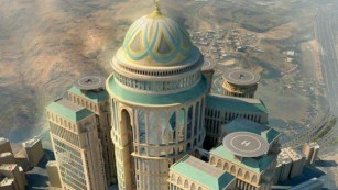
Search

GEOGRAPHY EDUCATION

Supporting geography educators everywhere with current digital resources.

Category

Uncategorized

The Anatomy of a Tornado

Jim Cantore gives an INCREDIBLE step-by-step description and 3D view into how a tornado forms – like you’ve never seen before!

Tags: physical, weather and climate, visualization.

Source: www.youtube.com

The Chinese Art of the Crowd

After viewing news photographs from China for years, one of my favorite visual themes is “large crowd formations.” Whether the subject is military parades or world-record attempts, mass exercises or enormous performances, the images are frequently remarkable. The masses of people can look beautiful or intimidating, projecting a sense of strength and abundance. Individuals can become pixels in a huge painting, or points on a grid, or echoes of each other in identical uniforms or costumes.


Tags: China, East Asia, cultureart, landscape.

Source: www.theatlantic.com

Before-and-after maps show how freeways transformed America’s cities

Beginning in the 1950s, cities demolished thousands of homes in walkable neighborhoods to make room for freeways.

At the time, this was seen as a sign of progress. Not only did planners hope to help people get downtown more quickly, they saw many of the neighborhoods being torn down as blighted and in need of urban renewal.  But tearing down a struggling neighborhood rarely made problems like crime and overcrowding go away. To the contrary, displaced people would move to other neighborhoods, often exacerbating overcrowding problems. Crime rates rose, not fell, in the years after these projects.  By cutting urban neighborhoods in half, planners undermined the blocks on either side of the freeway. The freeways made nearby neighborhoods less walkable. Reduced foot traffic made them less attractive places for stores and restaurants. And that, in turn, made them even less walkable. Those with the means to do so moved to the suburbs, accelerating the neighborhoods’ decline.

Source: www.vox.com

Later this month I will be in Cincinnati (pictured above) and will see firsthand some of the urban changes that freeways have had on the landscape, neighborhoods, and the lives of residents.  This article has some “swipe” aerial photography on Cincinnati, Detroit, and Minneapolis for your analysis. 

Tags: urbantransportation, planning, historical, urban models, APHG, neighborhoodCincinnati

Floods might have doomed prehistoric American city

Cahokia settlement’s decline began in 1200, around time of major Mississippi River surge.

Source: www.nature.com

In a flat landscape, what represents power more than a towering mound?  My family loved our excursion to this site and it show so many geographic issues. 

Tagsfluvial, geomorphology, erosion, landscape, environment depend, environment adapthistorical.

Map of Most Common Race

“The map above shows the most prevalent race in each county, based on data from the 2013 American Community Survey 5-year estimates. Select and deselect to make various comparisons.”

Tags: cartography, mapping, visualization, census, ethnicity, race.

Source: flowingdata.com

Austin, then and now

“Drag or swipe the slider to see how Austin’s downtown skyline has changed over time.”

Tags: urban, planning, urbanism.

Source: projects.statesman.com

Historian Says Don’t ‘Sanitize’ How Our Government Created Ghettos

“We have a myth today that the ghettos in metropolitan areas around the country are what the Supreme Court calls ‘de-facto’ — just the accident of the fact that people have not enough income to move into middle class neighborhoods or because real estate agents steered black and white families to different neighborhoods or because there was white flight.  It was not the unintended effect of benign policies, it was an explicit, racially purposeful policy that was pursued at all levels of government, and that’s the reason we have these ghettos today and we are reaping the fruits of those policies.”

Tags: economicrace, racism, historical, neighborhoodpodcast, urban, place, poverty, socioeconomic.

Source: www.npr.org

How to Make an Attractive City

We’ve grown good at making many things in the modern world – but strangely the art of making attractive cities has been lost. Here are some key principles for how to make attractive cities once again.

Source: www.youtube.com

While we can’t objectively measure beauty, in this video from the School of Life, London-based Swiss writer Alain de Botton offers a cheeky, thought-provoking, six-point manifesto on the need for making beauty a priority in urban architecture and design. Alain de Botton feels that tourism can be seen as helpful proxy variable for what the general public perceives as good urbanism that makes for beautiful cities.  The six main points of this article are:

  • Order and Variety
  • Visible Life
  • Compact
  • Orientation and Mystery
  • Scale
  • Local

Tags: urban, planning, urbanism, culturearchitecture, tourism.

10 truly absurd features of contemporary geopolitics

“The U.N. Security Council. What’s Up With That?  And 9 other truly absurd features of contemporary geopolitics.”

Source: foreignpolicy.com

“Some of these absurdities persist because they’ve been around a long time, or because powerful interests defend them vigorously, or because they align with broader social prejudices. Some of them may in fact be defensible, but we should still bring such oddities out into the open air on occasion and ask ourselves if they really make sense.”

Tags: political, geopolitics.

Create a free website or blog at WordPress.com.

Up ↑