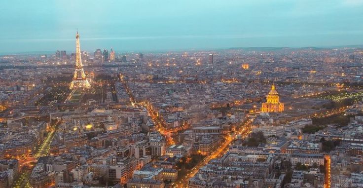
Search

GEOGRAPHY EDUCATION

Supporting geography educators everywhere with current digital resources.

Category

Uncategorized

Maeklong Railway Market

“Multi-purpose land use.”

Source: www.youtube.com

There are many videos online showing the Maeklong Railway Market, but I’ll share just a few. Clearly the 8 times a day runs like clockwork for the vendors, but as this other video shows, the 8 times a day that the trains go through the market an it becomes a tourist attraction. My students are usually quite shocked to see how this city market in Thailand operates and this video is a usefully ‘hook’ for lesson on population growth, urbanization, economic development, sustainability, megacities and city planning. 


Questions to Ponder: Why does this system work in Thailand, but is inconceivable for the United States?  How many spaces are single use spaces that remain empty most of the day?  How does the both the train line and the market need to accommodate the other? 


Tags: Thailand, Southeast Asiaurbanland use, megacitiesdevelopment, density, sustainability, planning.

California Drought Tests History of Endless Growth

A punishing drought is forcing a reconsideration of whether the aspiration of untrammeled growth that has for so long been the state’s engine has run against the limits of nature.

Source: www.nytimes.com

Major urban areas in California have limited local water resources so they draw water from large area to bring in sufficient water for these burgeoning metropolitan regions.  With this current drought getting worse, California has ordered emergency water restrictions on residents while companies and large farms have been granted exemptions even though they account for 82% of the state’s annual water consumption (residential accounts for 12%). Almond farms alone consume 10% of the state’s water, or as much as entire city of Los Angeles.


Questions to Ponder: How does the concept of carrying capacity relate to California urban growth/drought issues?  California passed its carrying capacity?  How are demographics, economics, politics and the environment intertwined in California?  What are the environmental limits on urban growth and development? 

Tags: physical, weather and climate, consumptionCalifornia, water, environment, resources, environment dependurban ecology.

Cultural Code-Switching

“The way we mix languages and speech patterns is an apt metaphor for the way race, ethnicity and culture intersect in our lives.”

Source: www.npr.org

Who we are, and how we behave is often dependent on the the circumstances and the cultural norms that govern those situations, places and relationships.  All of us, including President Obama, fit into many distinct cultural environments and the picture above shows a quick moment, when he can slip in and out of cultural settings (this was spoofed by Key and Peele). 

Questions to Ponder: When do you ‘code switch‘ and how come?  What does this mean for society at large and for the intersecting cultural groups with which we personally might identify?  When is this being fake or culturally inauthentic? 

Tags: culturelanguage, race, unit 3 culture.

Japan’s Disappearing Villages

In the small town of Nagoro, population 35, one woman is trying to save her village from extinction by creating life-sized dolls for every inhabitant who either dies or moves away.

Source: www.foreignaffairs.com

Japan has experienced rural to urban migration for decades now; simultaneously, Japan’s fertility rates have dropped far below replacement level.  While Tokyo is still bustling, small villages are shrinking to the point of disappearing.  This is a haunting and yet touching tribute to these emerging ghost towns.  It seems like a memorial to enshrine a sense of place before the memory of this place is forever eradicated–like a an earthen dam .  


Tags: Japan, declining population, population, demographics, unit 2 population, East Asialandscape, place.

Countries in multiple hemispheres

Source: www.worldatlas.com

The equator is a great circle that bisects the Earth into equal halves commonly referred to as the Northern and Southern hemispheres.  The map above shows a few of the countries that straddle the Eastern and Western hemispheres as defined by two important lines, the Prime Meridian and the 180th Meridian.  Now, only ONE COUNTRY is in all four hemispheres as defined by these great circles...any guesses before searching? 

ACTIVITY: A fellow geographer shared with me that he had a map from an old atlas showing latitudes as is typically presented but the lines of longitudes along the top and the bottom were based on two different systems. Greenwich was becoming the standard at the time it was printed, but this U.S.-published map also references longitude from Washington D.C. as the Prime Meridian.   So a fun classroom exercise would be to count multiple-hemisphere countries with DC set to 0 degrees. This can be repeated for any other city or landmark.

SPECIAL TRIVIA BONUS: That previous trivia fact is about as geo-nerdy as knowing what 2 countries in the world are double landlocked.  

Tags: fun, trivia.

What is the future of the world’s religions?

According to new Pew Research demographic projections, by 2050 there will be near parity between Muslims (2.8 billion, or 30% of the population) and Christians (2.9 billion, or 31%), possibly for the first time in history. Read more at http://pewrsr.ch/projections.

Source: www.youtube.com

This video is a sneak peak at some of the statistical projections from the Pew Research Center on what the world of religion will look like in 2050.  Here are the other highlights: 

  • The number of Muslims will nearly equal the number of Christians around the world.
  • Atheists, agnostics and other people who do not affiliate with any religion – though increasing in countries such as the United States and France – will make up a declining share of the world’s total population.
  • The global Buddhist population will be about the same size it was in 2010, while the Hindu and Jewish populations will be larger than they are today.
  • In Europe, Muslims will make up 10% of the overall population.
  • India will retain a Hindu majority but also will have the largest Muslim population of any country in the world, surpassing Indonesia.
  • In the United States, Christians will decline from more than three-quarters of the population in 2010 to two-thirds in 2050, and Judaism will no longer be the largest non-Christian religion. Muslims will be more numerous in the U.S. than people who identify as Jewish on the basis of religion.
  • Four out of every 10 Christians in the world will live in sub-Saharan Africa.

Tags: religionpopulation, culture, unit 3 culture.

If all the Ice melted: National Geographic’s Interactive map on Rising Seas

What if all the ice melted in the world? Now whether you believe global warming happens because of human activities or naturally is another debate. The questions “How would the world look if ALL the ice melted?” How much would the sea rise by? What would be the average temperature on Earth? are of interest to everyone.

Trust National Geographic not only to capture such questions in the best manner possible but also to visualize it in such geoawesome manner! Here’s the super interesting map by National Geographic “IF ALL THE ICE MELTED“!

Tags: physical, weather and climateNational Geographic, climate change, water, visualization.

Source: geoawesomeness.com

Non-Native American Nations Control over North America

Source: upload.wikimedia.org

Above is a still image of this intriguing animated GIF; it is a great teaching resource on the colonial claims in North America and the current political alignment on the continent. 


Tags: North Americahistorical, colonialism, borders, political.

Over population, over consumption – in pictures

“How do you raise awareness about population explosion? One group thought that the simplest way would be to show people in pictures the impact of population, pollution and consumption.”

Source: www.theguardian.com

This gallery is filled with excellent “teaching images” on human and environmental interactions and all aspects of geography–the one picture above shows how Mexico City has enveloped even the rolling hills as a part of its urban expansion.  


Tags: environmentlandscape, images environment depend, environment adapt, environment modify, pollution, resourcessustainability.

Create a free website or blog at WordPress.com.

Up ↑