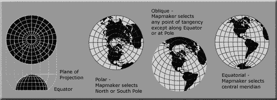
Search

GEOGRAPHY EDUCATION

Supporting geography educators everywhere with current digital resources.

Category

Uncategorized

Redrawing the map of Europe

“Fantasy cartography: An animated redrawing of the map of Europe.
Imagine a world in which countries could move as easily as people. A suggestion for a rearranged Europe.”

Source: www.youtube.com

What makes a region a region?  What criteria is being used?   This video could be used to ask questions on how they would create regions.  Which places will get split apart and which places will be lumped together? 

Tags: regions, Europe.

Roam the World in (Almost) Real Time

A groundbreaking Mapbox project ushers in a new era for online cartography.

On Google Earth, the seasons rarely change. Most anywhere a digital traveler goes, the sky is cloudless and the grass is green. No snow on the ground in Iowa. No fire in Valparaiso. It’s a big gap between the world as it is and as it’s mapped.

Launched Thursday, a landmark project from Mapbox has changed the summertime paradigm for online cartography. Landsat-live reveals the planet’s surface in real time and in stunning resolution, fed by a constant stream of public-domain imagery from NASA’s Landsat 8 satellite.

Source: www.citylab.com

Burma’s bizarre capital: a super-sized slice of post-apocalypse suburbia

The purpose-built city of Naypyidaw – unveiled a decade ago this year – boasts 20-lane highways, golf courses, fast Wi-Fi and reliable electricity. The only thing it doesn’t seem to have is people, report Matt Kennard and Claire Provost

Tags: Burma, Southeast Asia, urban, urbanism.

Source: www.theguardian.com

Vintage Video of NYC

“Oldest and most incredible footage of New York City ever, including where the WTC would be built. With added maps carefully researched to show where the camera was. 28 shots of classic footage circa 1905.” http://tinyurl.com/ohsuobg

Tags: urban, historicalarchitecture, landscape, NYC.

Source: www.youtube.com

This Louisiana radio station likes their news ‘en Franglais’

For more than half a century, one small commercial radio station has been keeping French alive in the bayous of Louisiana.

Source: www.pri.org

This PRI podcast on Louisana’s cultural geography goes nicely with this NY Times article on the same topic.    

Tagslanguage, folk cultures, culture, podcast.

200 years of immigration to the U.S., visualized

“Where have immigrants to the U.S. come from? Natalia Bronshtein, a professor and consultant who runs the blog Insightful Interaction, created this fascinating visualization of the number of immigrants to the U.S. since 1829 by country of origin.  The graph hints at tragic events in world history. The first influx of Irish occurred during the potato famine in 1845, while the massive influx of Russians in the first decade of the 20th Century was driven by anti-Semitic violence of the Russian pogroms (riots). Meanwhile in the Austro-Hungarian Empire, army conscription and the forced assimilation of minority groups drove people to the U.S. in the early 1900s.  Since WWII, Central and South America and Asia have replaced Europe as the largest source of immigrants to the U.S. Immigration shrunk to almost nothing as restrictions tightened during WWII, and then gradually expanded to reach its largest extent ever in the first decade of the 21st Century.”

Tags: migration, historical, USAvisualization.

Source: knowmore.washingtonpost.com

Looking For Real-World Math Problems? Try Google Earth!

Aiming to get kids to understand and solve real-world math problems, one teacher developed a tool that uses Google Earth.

Tags: math, google.

Source: blogs.kqed.org

Nat Geo Kids on YouTube

“Did you know 300 hours of video are uploaded to YouTube every minute? That’s a lot of video to sort through! Luckily, National Geographic Kids has done the work for you. We’re bringing you the best videos the Internet has to offer! 


National Geographic Kids playlists are an exciting way to 

discover the very best of YouTube. Hosted by kids for kids, we’ve created amazing playlists on awesome animals, cool science, funny pets, and more. With a new playlist added regularly, we’re the best destination for curious kids like you to explore, laugh, and learn. So pick a topic you love and start watching today!”

Tags: National Geographic, K12, biogeography.

Source: kids.nationalgeographic.com

On St. Patrick’s Day, Mexico remembers the Irishmen who fought for Mexico against the US

Amid the celebrations this St Patrick’s Day, there are also more somber commemorations taking place. In Mexico and in a small town in Galway, Ireland, they are remembering the hundreds of Irishmen who died fighting for Mexico against the United States: the San Patricio Battalion.

Source: www.pri.org

On St. Patrick’s Day and afterward, many people shared happy pictures of Ireland, and that’s lovely but I wanted this story.  This is not a well-known story in the United States because it reveals the cultural prejudice against the Irish that was prevalent in the United States in the 1840s.  I first learned about them in Mexico City, walking by a monument, that memorialized St. Patrick’s Battalion.  They were a group of soldiers that deserted from the U.S. army and chose to fight with their Catholic brethren on the Mexican side.  

Questions to Ponder: Why are these historical events not usually mentioned in the U.S. national narrative?  Why is this seen as very significant for Mexican national identity?  What were the ‘axes of identity’ that were mattered to the those in St. Patrick’s Battalion?   


Tags ethnicitywar, Mexico, Irish, racismreligion.

Blog at WordPress.com.

Up ↑