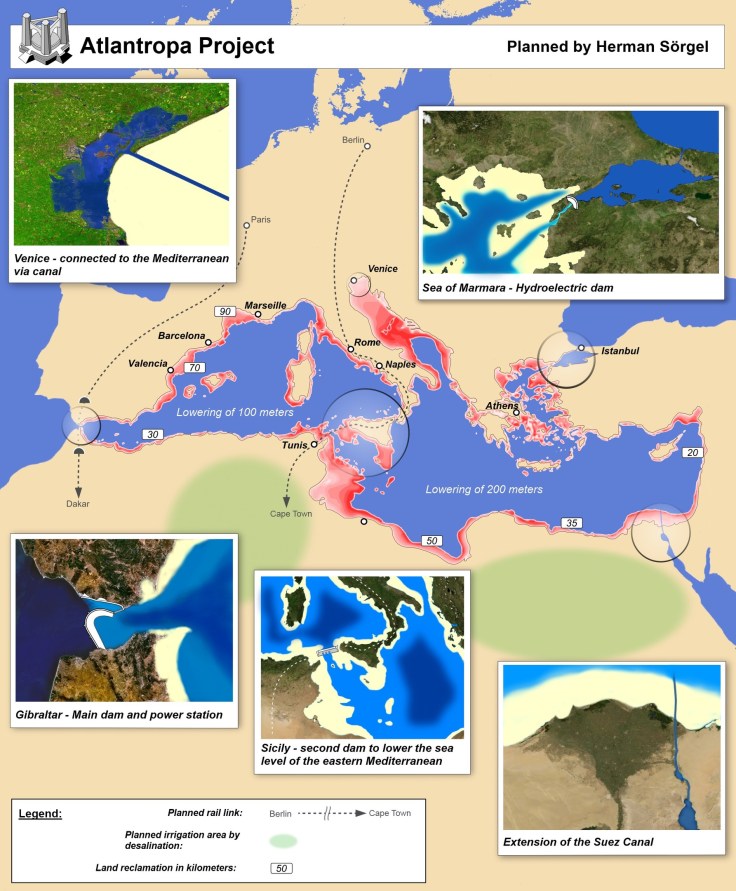
Maps of countries, infrastructure projects, and invasions that never were — but might have been.
Source: www.vox.com
Many of these are great examples of counter-factual histories–or the great “what ifs” in history.
Tags: mapping, historical.
Maps of countries, infrastructure projects, and invasions that never were — but might have been.
Source: www.vox.com
Many of these are great examples of counter-factual histories–or the great “what ifs” in history.
Tags: mapping, historical.
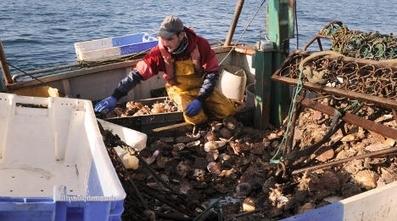
Scallops pulled out of the waters off the western coast of France are taken on an incredible journey that sees them shipped off to China to be cleaned, before being sent all the way back to France to be cooked up. Producers say its worth the cost.
Source: www.thelocal.fr
This type of nonsense only makes sense in a world where the bottom dollar is the only way to way to evaluate decisions. However, resource conservation (think of the food miles!), fair labor prices, and the preservation of local cultural economies are certainly issues that should be considered.
Tags: food, economic, labor, globalization, food production, agribusiness, agriculture.


“The best 30 resources and posts on Geography Education from 2014.” http://www.scoop.it/t/geography-education
Source: www.scoop.it
‘Tis the season to look back on the year that was. There are some ‘Best of’ lists with great teaching applications produced this week such as the best satellite images of 2014, the worst natural disasters of 2014, and 50 states in 50 pictures. This committee of one has analyzed all the Geography Education resources shared this year and selected these 30 as the best, most important, or most useful resources from 2014.
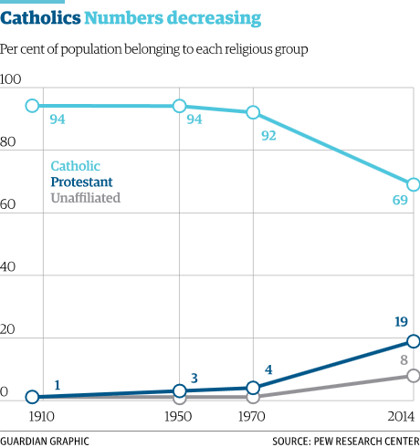
“A new report released by the Pew Research Centre has found that the proportion of Catholics in Latin America has dropped 25% since 1970. One of the primary drivers for the rise in the numbers leaving the Catholic Church? Conversion to Protestantism.”
Source: www.theguardian.com
This is an important cultural and demographic shift that is redefining how we think about Latin America. It also represents a major shift in the geography of the Catholic Church.
Tags: culture, religion, Christianity.

The Industrial Revolution gets credit for kicking off the world’s human population explosion, but new research suggests we should look further back.
“If you dig further in the past,” Stutz told Emory University, “the data suggest that a critical threshold of political and economic organization set the stage around the start of the Common Era. The resulting political-economic balance was the tipping point for economies of scale: It created a range of opportunities enabling more people to get resources, form successful families, and generate enough capital to transfer to the next generation.”
Tag: population.
Source: www.citylab.com

Many urban neighborhoods are places of concentrated poverty, and it’s killing opportunity in the US.
American cities are growing, and as they grow, they’re adding lots of high-poverty neighborhoods. Nearly three times as many “high-poverty” census tracts existed in 2010 as in 1970. That’s unsettling on its face but even more so when you see the havoc a poor neighborhood can wreak on a resident’s chances at a good life. Forget gentrification — this is a bigger problem.
The chart above tallies up the people living in these neighborhoods in 1970 and 2010. What it shows is that the number of people living in high-poverty neighborhoods — those with poverty rates of 30 percent or more — has roughly doubled since 1970. That’s because these neighborhoods of concentrated poverty have a tendency to stay that way, even while new ones sprout up.
Tags: urban, unit 7 cities, housing, economic, poverty, place, socioeconomic, neighborhood.
Source: www.vox.com

“The signs that something’s wrong are not immediately obvious, but, once you see them, it’s hard to tune them out. Curbs at nearly the exact same spot on opposite sides of the street are popped out of alignment. Houses too young to show this kind of wear stand oddly warped, torqued out of sync with their own foundations, their once-strong frames off-kilter. This is Hollister, California, a town being broken in two slowly, relentlessly, and in real time by an effect known as ‘fault creep.’ A slow, surreal tide of deformation has appeared throughout the city.”
Tags: disasters, geomorphology, California, physical.
Source: www.thedailybeast.com
The National Geographic Society has been inspiring people to care about the planet since 1888. National Geographic Maps publishes more than 100 new print maps annually and is a leading developer of digital map content found in websites and award-winning mobile apps. All proceeds from the sale and licensing of National Geographic maps go to support the Society’s vital exploration, conservation, research and education programs. www.natgeomaps.com
Source: maps.google.com
Have you ever wanted an archive of all the fabulous maps produced by National Geographic? And what if you could preview a digital version of all of these NatGeo maps seamlessly on Google Maps? That is exactly what this gallery delivers.