Source: arcgis.mla.org
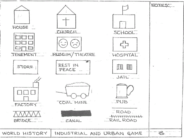
“Each student should have a large piece of butcher block paper (15×20). They should use a pencil for this activity (color pencils are optional).Using the template provided, each student should make their own template. It is crucial that size for each of the ‘characters’ in the city be the same. As you read each of the Rounds, your pace should increase so that by Round 15 the students will only have a short time to draw their buildings.”
Source: www.thecaveonline.com
In this game, you simulate the industrial revolution and have your students design a village that, after 20 rounds of the simulation, will grow to a full-fledged city. Various teachers have adapted the rules for this game and here are some variants that are saved as a standard webpage, Microsoft Word file, PDF, Powerpoint and Prezi formats.
How do you see it? http://theflatearthsociety.org/cms/ http://www.tfes.org/
Source: www.youtube.com
DISCLAIMER THAT I WISH I DIDN’T HAVE TO MAKE: I don’t believe in the flat Earth theory and think that this video is total jibberish; but it is delightfully inaccurate! This is a good way to get students to think critically about epistemology (how we know what we know) and defend their own world view. This also helps students to assess the validity of online sources.
Tags: social media.
Animation from http://earth.nullschool.net – windspeed at 10 hPa (about ~26500m / ~87000 feet above sea level)
Source: www.youtube.com
Maps have always been a source of fascination and intrigue. Today’s maps, however, can also help to save lives during disasters, document human rights abuses and monitor elections in countries under repressive rule. This presentation will explain how today’s live maps can combine crowds and clouds to drive social change.
Source: www.youtube.com
On this Thanksgiving, I want to remind this community that geospatial skills can be used to help others. Want to see geographic knowledge and geospatial skills in action? Crowd-sourced mapping is increasingly an important resource during an emergency. Poorer places are often not as well mapped out by the commercial cartographic organizations and these are oftentimes the places that are hardest hit by natural disasters. Relief agencies depend on mapping platforms to handle the logistics of administering aid and assessing the extent of the damage and rely on these crowd-sourced data sets made by people like you and me.
Source: blog.education.nationalgeographic.com
I am very pleased to be blogging for National Geographic Education. Here is the link to my first post on the geography of Thanksgiving.
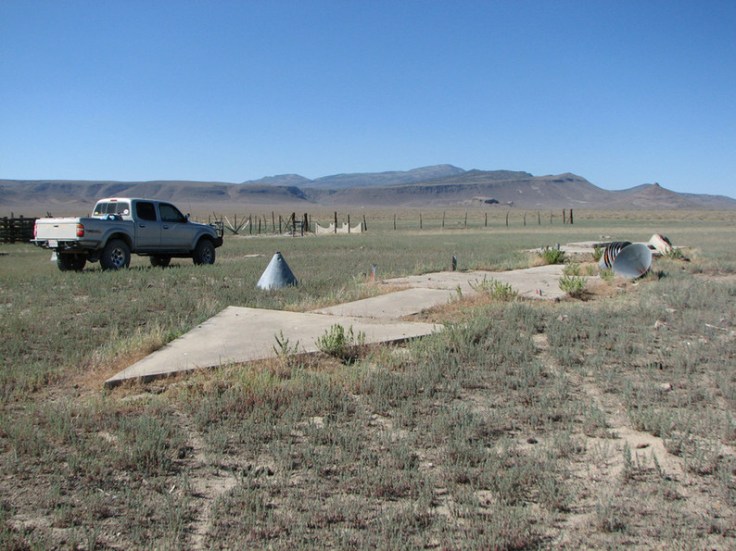
Every so often, a hiker or a backpacker will run across something puzzling: a ginormous concrete arrow, as much as seventy feet in length, just sitting in the middle of scrub-covered America. What are these giant arrows? Jeopardy champ Ken Jennings solves the mystery.
Source: www.cntraveler.com
This is fascinating…just because a technology is old and outdated in modern society doesn’t mean it wasn’t ingenious. The original mathematicians who calculated angles and distances study geometry so they could navigate and ‘measure the Earth.’ Before GPS, these giant arrows helped pilots navigate across the United States; they are part of the genealogical strands of navigational technology. Mathematics can be incredibly spatial as well as geospatial.
Tags: mapping, GPS, math, geospatial, location, historical.

Gathered around the Thanksgiving table, Americans tell stories about colonists and Native Americans coming together. But do Native Americans even celebrate Thanksgiving? And what would Native American heritage food look like? This November, With Good Reason takes a look at the indigenous side of a Thanksgiving table.
Source: withgoodreasonradio.org
This podcast is a great look at the diverse ways in which a national holiday can be celebrated. The cultural connections in the podcast are quite rich.
Tags: Thanksgiving, food, seasonal, folk culture, culture, indigenous.
“While the terms country, state, and nation are often used interchangeably, there is a difference.”
Source: www.youtube.com
These words are messy and this talk seeks to define them more precisely so that we can more fully understand political geographic complexity.
The concept of the nation-state emerged out of particular historical context as this video demonstrates. Additionally, here is another video that is a straightforward explanation of important vocabulary terms for a political geography unit.


