Search

GEOGRAPHY EDUCATION

Supporting geography educators everywhere with current digital resources.

Geographic analysis for the zombie apocalypse

Can geography save your life in case of, say, a zombie apocalypse? Understanding the push and pull factors that create geographic movement — or how people, resources, and even ideas travel — might help you determine the location that’s best for survival. David Hunter playfully analyzes the geography skills that you’d need to escape the zombies.

Source: www.youtube.com

This tongue -in-cheek TED-ED lesson shows how the concepts of movement are spatial, and of course, critical in an zombie apocalypse.  Good vocabulary (push factors, pull factors, migration, infrastructure, etc.) is used in this clip.  


Tags: mobilitymigration, TED, video.

Quebec urges shopkeepers to stop saying ‘Hi’

The unofficial greeting in the bilingual Canadian city of Montreal has long been a friendly ‘Bonjour, Hi!’ But that standard is no more since a motion mandating store clerks to greet customers only in French was passed in Quebec’s provincial legislature. The move reaffirms French as the primary language in the province, where use of English can be controversial. The motion – which is not a law – was passed unanimously, but the province’s premier called the debate ‘ridiculous’. Introduced by the fiercely Francophile Parti Quebecois, the motion ‘invites all businesses and workers who enter into contact with local and international clients to welcome them warmly with the word bonjour‘.”

Source: www.bbc.com

This is a great example of how culture isn’t just passively received, but it’s actively constructed.  The call to defend cultural traits of a region to maintain it’s local distinctiveness is oftentimes why a region has a strong sense of place.  


TagsCanadalanguage, placeculture, landscape

xkcd: A Critique of Viral Maps

Source: xkcd.com

This ‘map’ is a pithy and quite pointed critique of the many maps that get shared on social media claiming to be based on big data, but they might be more fluff than true substance. 


Tags: XKCD, infographic, mapping, social media, cartography.

Gibraltar Bay

“Gibraltar Bay, located near the southernmost tip of the Iberian Peninsula, is the central feature of this astronaut photograph. The famous Rock of Gibraltar that forms the northeastern border of the bay is formed of Jurassic-era seafloor sediments that solidified into limestone, a rock formed mostly of the mineral calcite, which is found in the shells of sea creatures. The limestone was subsequently lifted above the ocean surface when the African and Eurasian tectonic plates collided.”

Source: earthobservatory.nasa.gov

Gibraltar is an exclave of the UK on a peninsula connected to the Spanish mainland that controls access to the Mediterranean Sea; there is naturally going to be friction over this unusual political configuration. “La Linea” marked on the image is the international border


Questions to Ponder: Why are both Spain and the UK invested in this piece of territory?  What challenges are there for a small exclave when neighbors aren’t friendly?  How does Spanish and British supranational connections impact this issue?


Tags: borders, political, Spain, Europe.

Why Somaliland is east Africa’s strongest democracy

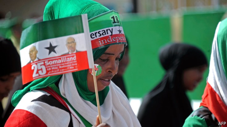
“Though unrecognized by the international community, the country benefits from a strong social contract between government and citizens.”


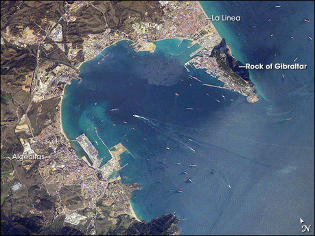
Drop a pin on a map of eastern Africa and chances are it will not land on a healthy democracy. Somalia and South Sudan are failed states. Sudan is a dictatorship, as are the police states of Eritrea, Rwanda and Ethiopia. In this context tiny Somaliland stands out. Somaliland was a British protectorate, before it merged with Italian Somalia in 1960 to form a unified Somalia. It broke away in 1991, and now has a strong sense of national identity. It was one of the few entities carved up by European colonists that actually made some sense. Somaliland is more socially homogeneous than Somalia or indeed most other African states (and greater homogeneity tends to mean higher levels of trust between citizens). For fear of encouraging other separatist movements in the region, the international community, following the African Union, has never obliged [to recognize Somaliland]. Nation-building on a shoestring helped keep Somaliland’s politicians relatively accountable, and helped to keep the delicate balance between clans.


Tags: devolutionpolitical, states, sovereignty, autonomy, unit 4 political, Somalia, Africa.

Source: www.economist.com

Choosing a Map Projection

“Cartographers at National Geographic discuss how they select an appropriate map projection for the September 2012 magazine map supplement. –World maps usually center on the land, with the Pacific Ocean divided as bookends. To show each ocean as a whole with the least distortion for our ‘Beneath the Oceans’ supplement map, we used a map projection called an interrupted Mollweide centered on the Pacific.”

Source: www.youtube.com

There is no one perfect map projection that fits all circumstances and situations. Think of a situation in which this map projection would be an ideal way to represent the Earth and in another situation that same projection would give you an incredibly limited perspective.  This video provides good insight into how to choose a map projection for a cartographic project. Here is National Geographic’s lesson using this video.

Tags: cartography, K12, geospatial, NationalGeographic, water.

English–Origins and Roots

When we talk about ‘English’, we often think of it as a single language. But what do the dialects spoken in dozens of countries around the world have in common with each other, or with the writings of Chaucer? Claire Bowern traces the language from the present day back to its ancient roots, showing how English has evolved through generations of speakers.

Source: www.youtube.com

English has obviously changed much over the years, but this video (and lesson) also shows some good language family information and traces it back to proto-Indo-European, using the English as the main example.  This other TED-ED video (and lesson) shows how the connotations of English words often times depend on the linguistic root (sweat–Germanic, perspire–Latin).   


Tags: languagecultureEnglishTED, video.

Globalization, Trade, and Poverty

What is globalization? Is globalization a good thing or not. Well, I have an answer that may not surprise you: It’s complicated. This week, Jacob and Adriene will argue that globalization is, in aggregate, good. Free trade and globalization tend to provide an overall benefit, and raises average incomes across the globe. The downside is that it isn’t good for every individual in the system. In some countries, manufacturing jobs move to places where labor costs are lower. And some countries that receive the influx of jobs aren’t prepared to deal with it, from a regulatory standpoint.

Source: www.youtube.com

There are many of the 35 videos in the Economics crash course set that touch on geographic issues, but I’d like to highlight episodes 16 and 17 especially.  Many see globalization as the path to economic growth and others see the process of globalization as what has created poverty.  In many ways both have a point as demonstrated in the 16th episode of this crash course.  In a follow-up video, they explain the difference between wealthy inequality and income inequality.  This video also has a nice layman’s explanation of the GINI coefficient and how it measures inequality.   


Tagsdevelopment, laborglobalization, economicindustry, poverty, crash course


Divided island: How Haiti and the DR became two worlds

Haiti and the Dominican Republic share a border, and an island. But the two countries are very different today: the Dominican Republic enjoys higher quality of life for many factors than Haiti. I went to this island and visited both countries, to try and understand when and how their paths diverged.

Source: www.youtube.com

This video is an exciting debut for the new series “Vox borders.”  By just about every development metric available, the Dominican Republic is doing better than Haiti, the only bordering country on the Caribbean island of Hispaniola with the DR.   


Questions to Ponder: How does the border impact both countries?  How has sharing one island with different colonial legacies shaped migrational push and pull factors?


Tags: Haiti, Dominican Republic, video, poverty, development, economic, labor, migration, political, borders.

Create a free website or blog at WordPress.com.

Up ↑