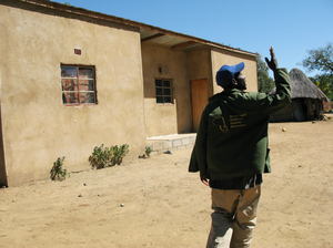
Search

GEOGRAPHY EDUCATION

Supporting geography educators everywhere with current digital resources.

Historic USGS Maps of New England & New York

See on Scoop.itGeography Education

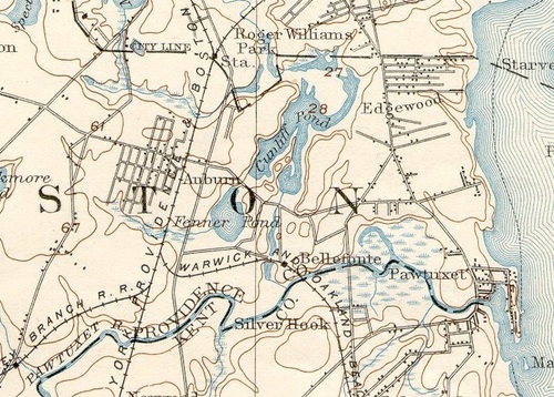
This historical collection of USGS 15 minute topographic maps dates from the 1890s to the 1950s. Geographic coverage is complete for New Hampshire and nearly complete for the rest of New England.

This is a great warehouse of historical maps of New England.  The picture above what is today South Providence and Cranston, but in 1894 the area around the lakes was a part of the City of Cranston.  Why would the city of Cranston ‘lose’ territory?  When did this happen?  This is just one example of the questions in historical geography that this resource can inspire.

See on docs.unh.edu

Botswana’s ‘Stunning Achievement’ Against AIDS

See on Scoop.itGeography Education

A decade ago, Botswana was facing a national crisis as AIDS appeared on the verge of decimating the country’s adult population. Now, the country provides free, life-saving AIDS drugs to almost all of its citizens who need them.


This is a great example, and possibly a template on how to tackle the AIDS/HIV crisis in Sub-Saharan Africa.  Botswana was as hard hit as any country, but they fully invested their economic initiatives into tackling this and actively changed cultural attitudes and behaviors that faciliate transmission.  Not all is ‘doom and gloom’ when looking at poverty and disease-stricken countries.   

See on www.npr.org

‘Why Should Boys Have All the Fun?’

See on Scoop.itGeography Education

Rather than focusing on how to make cities safe at any hour for citizens of both genders, the official response has been to curtail women’s access to public areas deemed sensitive by authorities.


This is an interesting topic to use to debate urban policies and planning issues.  What leads to a safer city for women?  How does the creation of zones not safe for women impact the city long-term?  Think about scale: Is what is best for the city policy what is best for the individual? 

See on blogs.wsj.com

Cows make less milk in hot sticky weather

See on Scoop.itGeography Education

Research news from leading universities…


Sometimes whe teach human geography as though it is not connected to physical geography.  The geographical distribution patterns of agriculture are some of the most highly correlated human activities to the physical environment.  This one, dairy productivity, changes greatly based on temperatures, humidity and latitude. 

See on www.futurity.org

Cultural Meaning in Moving Monuments

See on Scoop.itGeography Education

As a graduate student I wrote my dissertation on the meanings within the symbolic landscape.  Since very few are clamoring to read my 500 page dissertation, this is a sampling that shows one of my …


I didn’t intend for this to be the weekend of statue resources, but the Joe Paterno controversy (for more opinions on that see: https://geographyeducation.org/2012/07/13/the-joe-paterno-statue-on-penn-state-campus/ ) has me thinking of other controversial statues that I researched while in Mexico City.  I wrote an article in the Journal of Geography showing how you can teach cultural patterns and processes using contested monuments in the symbolic landscape.  Consider this site a supplemental resource to that article (with the original article, photos, videos and Google Earth files attached). 

See on geographyeducation.org

Screen-sharing with Join.me

See on Scoop.itGeography Education

How does join.me work? Take a tour and discover join.me.


This video is is the perfect introduction on how to collaborate with colleagues or students using http://join.me This site allows you to talk, chat and screen-share for free.  This is a must for anyone wanting virtual office hours or needing to remotely display their computer screen.  As long as you use it lightly, it is a free service. 

See on www.youtube.com

Think GPS is cool? IPS will blow your mind | ExtremeTech

See on Scoop.itGeography Education

For all of its awesome applications, GPS has two fundamental flaws: It doesn’t work indoors, and it can’t really detect altitude. An Indoor Positioning System would fix that — and introduce some seriously awesome applications.


Geolocation was listed as one of the important growth industriesfor the future (it also is a way to reassure students that the their are jobs for geography majors).  The IPS isn’t quite here, but it’s hard to imagine that is too far away. 

See on www.extremetech.com

How to Fool a GPS

See on Scoop.itGeography Education

What if you could use GPS technology to find your misplaced keys? How about if you could use that same technology to lie about where you were in the world or…

We know the common usages of GPS technologies.  As the accuracy of GPS data improves, how does this expand the potenial uses?  What are the ethnics and legalities of GPS tracking devices?  Just like hackers online alter the information with rely on, this video is an introduction to the analogous GPS spoofing technology.  This TED talk is a great exploration of the future of GPS technology and privacy issues.

See on www.youtube.com

Public Cemeteries and GIS

See on Scoop.itGeography Education

How to search for graves in the town of sylvan lakes lakeview cemetery.


This is a tangible example of public GIS data being used to help the community know more about it’s history.  What type of project could you do make with this kind of data?  How could a cemetery be the nexus for a interdisciplinary project?       

See on gis.sylvanlake.ca

Create a free website or blog at WordPress.com.

Up ↑