Search

GEOGRAPHY EDUCATION

Supporting geography educators everywhere with current digital resources.

Earth As Art : Pick Your Favorites!

See on Scoop.it – Geography Education
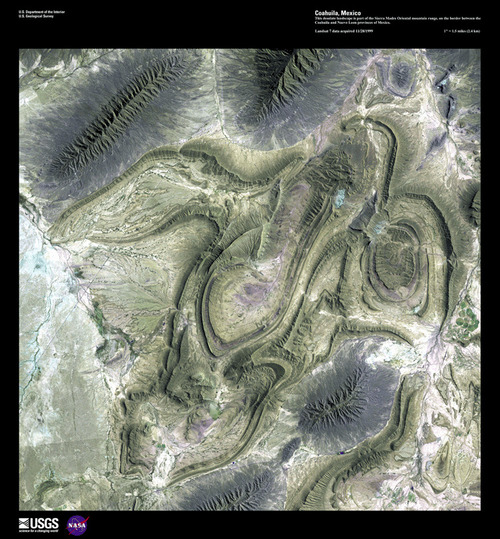
The USGS is celebrating 40 years of the LANDSAT

Program by having a competition to select the top 5 “Earth as Art” images from the more than 120 scenes from their curated collection.  All readers can select 5 images on the USGS website and the poll closes on July 6, 2012 (The image above is from Coahuila, Mexico).

See on eros.usgs.gov

Local Life Expectancies

See on Scoop.it – Geography Education

We often talk about life expectancy data at the national level; this simplification has a great deal of utility but obscures regional distinctions within a country.  Some counties in the United States have life expectancies on par with Japan (84), while the worst off counties are more similar to Indonesia (69).  Even more startling, in 661 counties, life expectancy stopped dead or went backwards for women since 1999.  This is a dramatic look at the importance of scale within any geographic analysis to arrive at reasonable conclusions.  So let’s start looking at local demographic data instead of just nationally aggregated data.  For more on this press release, see:  http://www.healthmetricsandevaluation.org/news-events/news-release/girls-born-2009-will-live-shorter-lives-their-mothers-hundreds-us-counties

See on www.healthmetricsandevaluation.org

London 2012: Where’s the lasting economic legacy?

See on Scoop.it – Geography Education

More than 75,000 firms that have helped to deliver London’s Olympic Games are fighting a 12-year gagging order preventing them from talking about the work they have done, it emerged last night.


London has undergone important urban projects that have transformed the numerous parts of the city.  These massive investments are now being questioned as some observers are skeptical as to whether or not their will be an adequate return on investment. 

See on www.independent.co.uk

The Connected States of America

See on Scoop.it – Geography Education

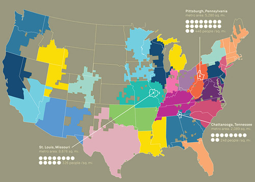
“This interactive map shows the county to county social interactions given in total call minutes or total number of SMS from the anonymous, aggregated AT&T mobile phone data. Click into your county or type it into the text box to find out how it is connected to other counties in the US. You can switch between call and SMS data to reveal the changes in interaction mode. Also, the population map is provided, which is based on the 2010 Census.”     -Martin Daumiller


See on senseable.mit.edu

Google Schools Apple on Maps

See on Scoop.it – Geography Education

Apple is expected to dump Google Maps from its operating system, in favor of its own product. In response, Google is showing off how much it has done in maps, and how many features it has.

Google Maps is on many devices, but Apple now appears poised to enter the mapping market more fully, including native Apple mapping apps for the iPhone and iPad designed to replace Google Maps.

See on bits.blogs.nytimes.com

Obesity: A Big Fat Problem For America’s Future

See on Scoop.it – Geography Education

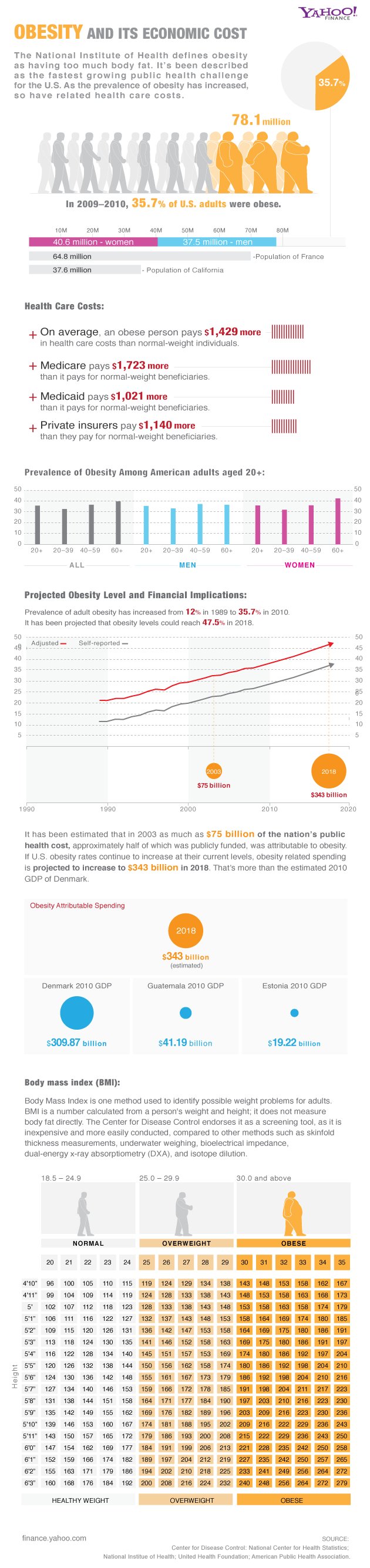
Like so many phenomena, there is a spatial nature to obesity (higher in the United States than global averages and higher in the deep South than national averages).  This infographic compiles statistics that are ‘food for thought.’

See on finance.yahoo.com

Breaking Caste: Dalit Girls Chance at a Better Life

See on Scoop.it – Geography Education

Inside an extraordinary school that gives India’s Dalit girls a chance at a better life…


Cultural change, especially traditions that are deeply engrained over many generations are difficult to reverse.  In India, the caste system is changing but not without tremendous efforts by individuals and institutions that are deeply committed to equality and expanding opportunities for the most socially vulnerable population.  There are a variety of videos and articles here that show how one school is making a difference in the lives of ‘untouchable’ girls to give them a hope for the future. 

See on www.theglobeandmail.com

The High Line

See on Scoop.it – Geography Education

The official Web site of the High Line and Friends of the High Line…


What do you do with an outdated elevated train line running through a crowded neighborhood in New York City?  In the 1980s, residents called for the demolition of the line as the eyesore since it was blamed for economic struggles of the community and increased criminal activity.  Recently, this has been converted into an elevated green space that has economically revitalized the local real estate.  Find out more about this innovated park and project.      

See on www.thehighline.org

Finding Shakespeare…with Google Earth

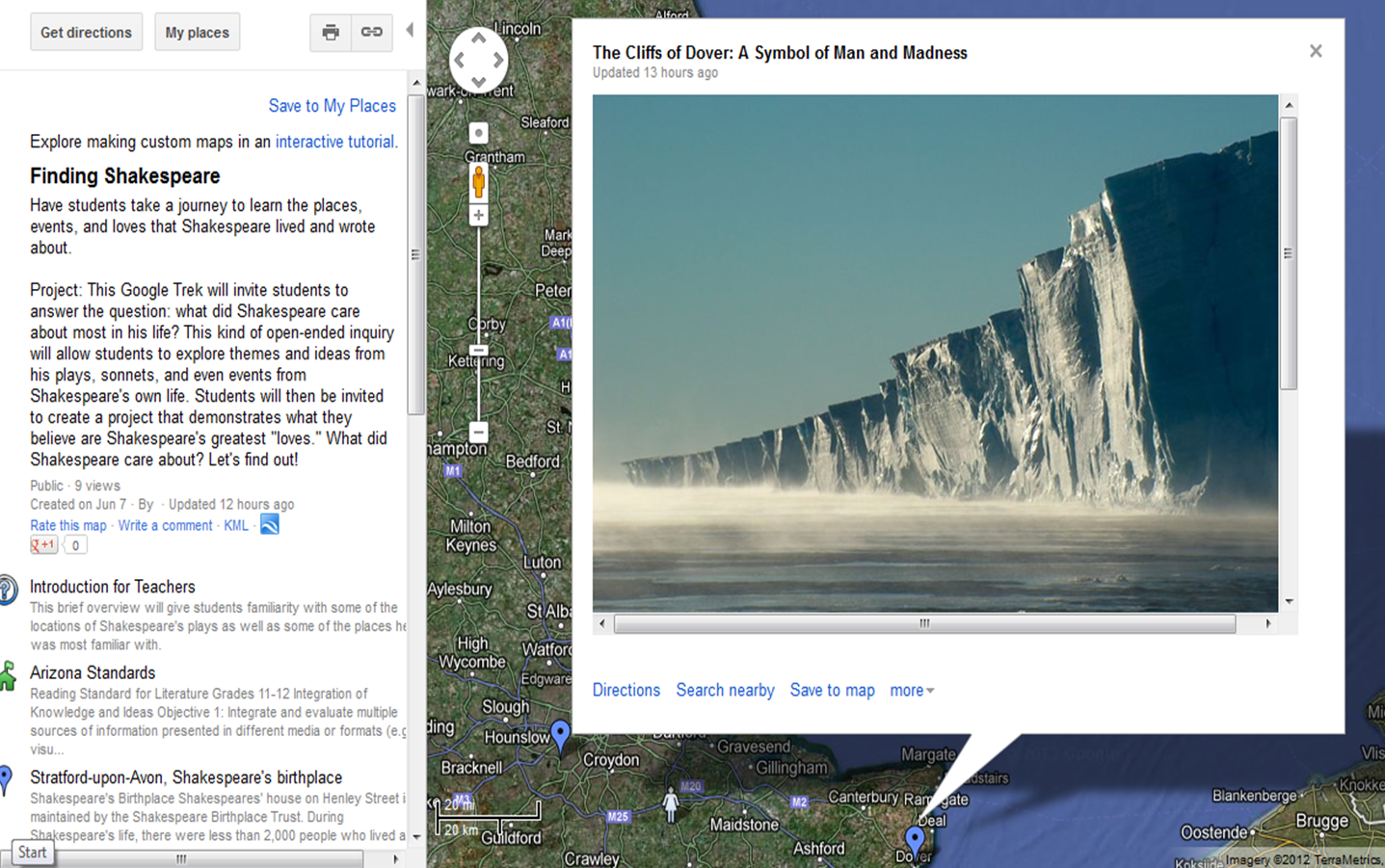
This interactive Google Earth file (KML download available) surveys the important places in the life and works of Shakespeare to add depth and context for an English class.  Produced by an Arizona State University ESL professor Shane Dixon (who happens to also be my awesome older brother), this learning module infuses geographic thought into the study of literature.  Many geography teachers bemoan the state of geography in education and I understand that frustration for more explicitly ‘geography’ courses; I also see this type of interdisciplinary activity as way to create a geography that is a part of all classrooms.  So talk to an English teacher about a collaborative project–it just might get you somewhere.

Blog at WordPress.com.

Up ↑