
“37 mind-boggling Great Lake facts.”
Tags: physical, environment, water.
Source: www.buzzfeed.com

Bern Szukalski shares his highlights from the latest release of ArcGIS Online.
Source: video.esri.com
This video is a great way to find out what is new in ArcGIS online this month. Some of the capabilities highlighted in this 10 minute video are:
Tags: GIS, ESRI, video, mapping, cartography, geospatial, technology.

“The ultimate list of the greatest wonders in the world.”
Source: www.listchallenges.com
I have been fortunate enough to have visited 53 of the places on this list (I have gaping holes in my list and the list itself has some gaping holes itself). All lists are highly subjective; this list, for example, is heay on urban/cultural/European tourism sites and light on physical/Asian/African destinations. Most geographers already have enough reasons to go traveling, but this list might spark more. Who wants to map out these places to verify that initial impression?
Questions to Ponder: Which places are on your dream list? Which places do you think should have been added to this list?
Tags: place, tourism, culture, landscape, geo-inspiration.

“Most food, if we trace it back far enough, began as a seed. And the business of supplying those seeds to farmers has been transformed over the past half-century. Small-town companies have given way to global giants. A new round of industry consolidation is now underway. Multibillion-dollar mergers are in progress, or under discussion, that could put more than half of global seed sales in the hands of three companies.”
Tags: food, economic, food production, agribusiness, podcast.
Source: www.npr.org
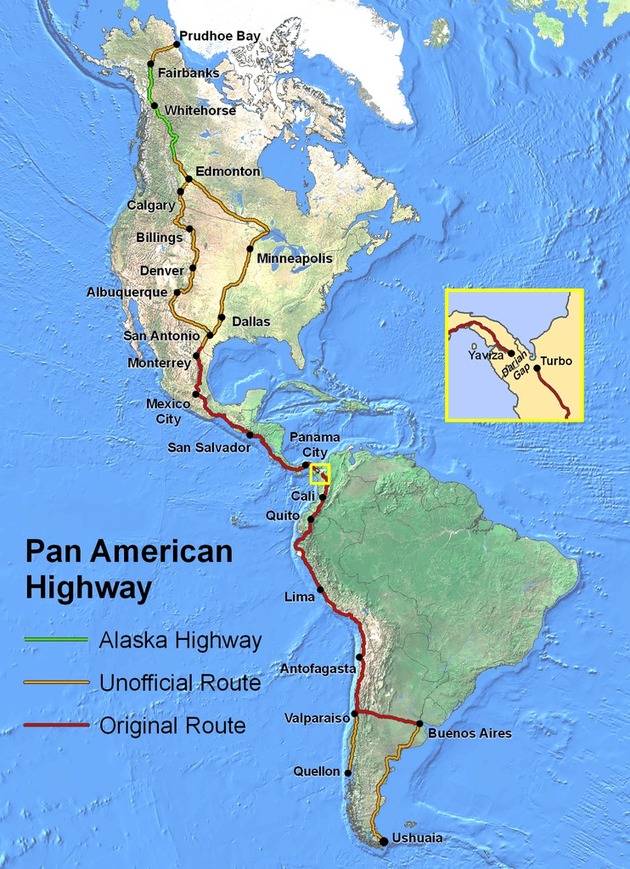
At its fullest extent the Pan-American Highway is a network of roads stretching from Prudhoe Bay, Alaska, to Ushuaia, Argentina, a distance of around 30,000 kilometres (19,000 miles).
Source: brilliantmaps.com
I love a good road trip, and I while I love the idea of traversing the entire length of the Americas, I think that the idea of it might be better than the actual trip (at least will my kids in the back seat).
Tags: mobility, transportation, tourism, South America, Middle America.
The Czech Republic is expected to change its name to “Czechia” to make it easier for companies and sports teams to use it on products and clothing.
Source: www.bbc.com
That sound you hear is cartographers and database managers gasping at the joy and shock of need to updata all their data and maps. Old maps still show Czechoslovakia, maybe on date in the future someone will be excited to find “The Czech Republic” on the map as much as I was fascinated to discover Hindustan on a 19th century globe.
“The phrase ‘Free, white, and 21’ appeared in dozens of movies in the ‘30s and ‘40s, a proud assertion that positioned white privilege as the ultimate argument-stopper. It was a catchphrase of the decade, as blandly ubiquitous as any modern meme: a way for white America to check its own privilege and feel exhilarated rather than finding fault. Read more about the history of the phrase here.”
Source: www.youtube.com
I found this glimpse into the American past as startling, even if it shouldn’t be. It jarred me because today many in America bristle or are startled at the notion that ‘white privilege’ exists today even if there are countless examples that we do not live in a post-racial society. This glimpse of old-school Hollywood shows how asserting white privilege was common place in the lexicon–equally fascinating is how we’ve pretended that it never was. White privilege is no longer flouted in polite company like it once was, but that doesn’t mean that it isn’t real.
Tags: race, cultural norms, language, racism, culture, unit 3 culture.
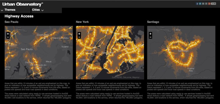
“The Urban Observatory city comparison app enables you to explore the living fabric of great cities by browsing a variety of cities and themes.”
Source: www.urbanobservatory.org
At the 2013 ESRI User Conference, the Urban Observatory was unveiled (I shared this earlier, but the URL has since changed, I’m sharing it again). The physical display contained images from cities around the world to compare and contrast diverse urban environments. The online version of this was announced during in a 10 minute talk by Jack Dangermond and Hugh Keegan. This interactive mapping platform let’s users access ‘big data’ and have it rendered in thematic maps. These maps cover population patterns, transportation networks, and weather systems. This is a must see. Read Forbes’ article on the release of Urban Observatory here.
Tags: transportation, urban, GIS, geospatial, ESRI.
150 years of tension may be coming to an end.
Source: www.youtube.com
This video offers some good perspective on the competing historical visions that help to shape the tension between the United States and Cuba. I enjoyed this one because it explicitly states during what many refer to as the age of imperialism.
Questions to Ponder: How would you feel about the normalizing of political and economic relations between the United States and Cuba if you grew up in Cuba? What if you were from a Cuban-American family that fled Castro’s regime?
Tags: Cuba, historical, conflict, political, geopolitics, colonialism, video.


