Search

GEOGRAPHY EDUCATION

Supporting geography educators everywhere with current digital resources.

Tag

environment modify

Cahokia – why did North America’s largest city vanish?

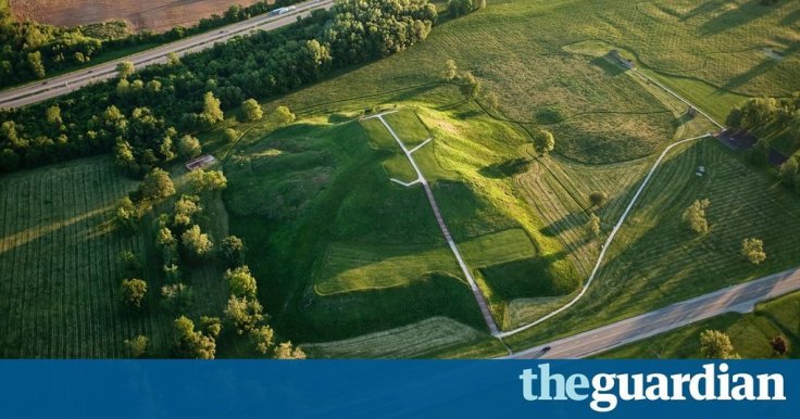
Long before Columbus reached the Americas, Cahokia was the biggest, most cosmopolitan city north of Mexico. Yet by 1350 it had been deserted by its native inhabitants the Mississippians – and no one is sure why

Source: www.theguardian.com

This article is the eighth in the “Lost Cities” series (Babylon, Troy, Pompeii, Angkor, Fordlandia, etc.).  The earthen mounds of Cahokia on the flat flood plains must have been the most awe-inspiring demonstration of political power and economic wealth in its day.  Like so many other civilizations before them (and many more in the future?), Cahokia probably declined from too many environmental modifications that led to unforeseen consequences.


Tagsurban ecology, indigenousenvironment, environment modify, historical, North America.

Live chart: Fish stocks

“The world’s fish are in danger—as is everyone who depends on them.”

Source: www.youtube.com

Every semester I share with my students this New York Times video about the rapid rise in industrial fishing and the production of Talapia.  Even with the rise of aquaculture as a major source of seafood, the world’s oceans are still depleted.  As the world’s population rises, many folk cultures with their roots in small fishing villages have transformed into primarily urban societies, but these urban societies still have a strong cultural preference for seafood and consume at levels that are not sustainable.    


Tags: environment modifyfolk culturesconsumption, water, physical.

How Geospatial Analytics Are Changing Habitat Conservation

“The BirdReturns program is an effort to provide ‘pop-up habitats’ for some of the millions of shorebirds, such as sandpipers and plovers that migrate along the Pacific Flyway, a route that spans from Alaska to South America. Birds flying on this journey seek out the increasingly rare wetlands teeming with tasty insects to fuel their long-distance flights.  Over the last century, California’s Central Valley has lost 95% of the wetlands habitat to development, agriculture, and other land use changes. As a solution, scientists use big data, binoculars, and rice paddies.”

Source: www.youtube.com

This project combines data from satellite imagery to map surface water in California’s Central Valley, and individual bird observations to select locations that can be temporarily converted into wetlands to aid the migratory birds (for more information than the video provides about this project, read this article). 


This is a great example of using both ‘big’ geospatial data as represented by the satellite imagery and combining it with field data and actual observations to make the world a better place.  We need more decision makers that can think spatially and use geographic skills.  


Tags: physicalCalifornia, water, environmentbiogeography, remote sensing.

Drought Drains Lake Mead to Lowest Level

“The largest reservoir in the U.S. falls to its lowest water level in history, Nevada State Sen. Tick Segerblom introduced a bill title and issued a press release on July 8 calling for an ‘independent scientific and economic audit of the Bureau of Reclamation’s strategies for Colorado River management.'”

This week’s history-making, bad-news event at Lake Mead has already triggered lots of news stories, but almost all of these stories focus on the water supply for Las Vegas, Phoenix and California. But what about the health of the river itself?

Tags: physicalfluvial, drought, water, environment.

Source: ecowatch.com

Ethiopia’s Dam Problems

“Ethiopia is three years from completing a dam to control its headwaters, and while Egypt points to colonial-era treaties to claim the water and to stop the project, the question remains as to who own the Blue Nile.”

Source: maps101blog.com

This 7-minute Geography News Network podcast (written by Julie and Seth Dixon) touches on some key geographic concepts.  85% of the Nile’s water comes from the Blue Nile that originates in the Ethiopian highlands–it is the Blue Nile that Ethiopia has been working on damming since 2011.  The Grand Ethiopia Renaissance Dam (GERD) will be located  near the border with Sudan.  Egypt is adamantly opposed to Ethiopia’s plan and is actively lobbying the international community to stop construction on the dam, fearing their water supply with be threatened. 

Tags: Ethiopia, Africa, development. environment, water, energy, borders, political.

Sustaining Seven Billion People

“With seven billion people now living on Earth, the ever growing demand is putting unprecedented pressure on global resources—especially forests, water, and food. How can Earth’s resources be managed best to support so many people? One key is tracking the sum of what is available, and perhaps nothing is better suited to that task than satellites.”

Source: earthobservatory.nasa.gov

Agricultural production is one of the ways in which people modify the environment more than any other.  Global population is expected to top out at around 9 billion around 2050, so will we be able to sustainably feed all of the entire human population?  Satellite imagery can help answer these questions. 

Tagsremote sensing, geospatial, images, sustainability, agriculture, food production, environment modify, unit 5 agriculture

Create a free website or blog at WordPress.com.

Up ↑