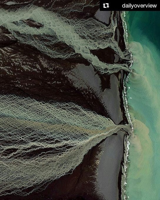
Glacial melting and flooding occurs every year by the Skafta River in Iceland. As the water travels down towards the North Atlantic Ocean, incredible patterns are created on the hillsides. Rising lava, steam vents, or newly opened hot springs can all cause this rapid ice melt, leading to a sizable release of water that picks up sediment as it flows down from the glaciers.
“Mont Saint-Michel emerges from the tides in Normandy, France, like an ancient village from a fairytale. The coastal town built on a massive granite rock cuts a dramatic silhouette against the sky, rising from disappearing marshes to a Gothic Abbey at its height. With a permanent population of around 50, this popular tourist destination has a history dating back to at least the Roman era. Fancy a tour before the tides roll in?”
Coastal physical geography produces some beautiful landforms such as tombolos. A tombolo is created when sand deposits attach an island to a larger piece of land–think of it as special type of isthmus. Mont St. Michel is the world’s most famous example because of the iconic walled city with crowned with a striking medieval abbey. This is one of those fascinating places for both the human and physical geographer.
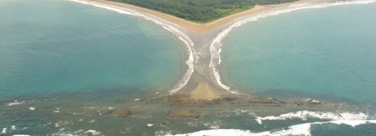
This National Park in Costa Rica is a delightful example of many things geographic. Not only is the local biogeography make this a place famous for whales (ballena in Spanish), but the physical geography also resembles a whale’s tail. This feature is called a tombolo, where a spit connects an island or rock cluster to the mainland. Additionally, there is also a great community of citizen cartographers mapping out this park and the surrounding communities.
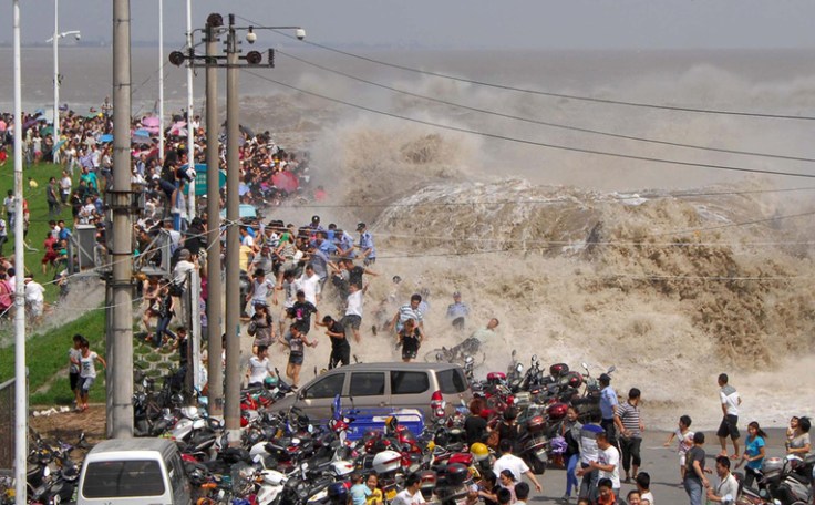
For hundreds of years, on the eighth month of the lunar calendar, people have gathered along the shores of China’s Qiantang River at the head of Hangzhou Bay to witness the waves of its famous bore tide. Higher-than-normal high tides push into the harbor, funneling into the river, causing a broad wave that can reach up to 30 feet high. If the waves surge over the banks, spectators can be swept up, pushed along walkways or down embankments. Below, I’ve gathered images from the past few years of the Qiantang bore tides.
This is an amazing set of images, where a cultural phenomenon is wrapped up in observing the pulsating physical geography of the river. Usually the tidal bore is impressive (but not dangerous–see video here), but occasionally it can be incredibly violent (see this 2015 video).
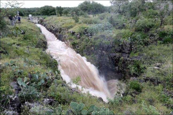
At this sinkhole, about 500 cubic feet of water per second is disappearing into the earth, the equivalent of an Olympic-sized swimming pool every three minutes, according to an engineer with the Edwards Aquifer Authority. For as much water reaches the aquifer at this spot, far more infiltrates through porous rock across South-central Texas.
Not all water runoff goes to rivers, lakes, and oceans. Some water percolates into soils that can absorb water (aquifers) but there are some soils such as clay that can’t absorb water (aquicludes or aquitards). In this dramatic example (see video), the water is not absorbed by the resistant rock, flows through a sinkhole to recharge the aquifer below.
Death Valley,California – Giant boulders in the desert look as though their moving all on their own! But could weird weather be behind these roving rocks
Since the video above was created, the mystery has been solved. On very rare occasions, when it rains in the region, water will accumulate in the playa (discovermagazine.com). If the wind is powerful and consistent enough, the wind will push the panels of ice against these rocks and over time, the ice floes will push these rocks, leaving behind distinctive trails (latimes.com). This perfect combination of water, wind, ice and heat creates a remarkable signature on the landscape (livescience.com). The video in this article (weather.com) nicely explains how the non-aerodynamic rocks of Death Valley’s Racetrack Playa move, leaving behind their trail in the hot desert. Numerous attempts using GPS receivers (NatGeo.com) and good ol’ fashioned observations have been made, but observing ice in Death Valley is so rare that no one had ever seen it until now (phys.org).