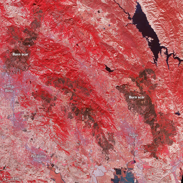
Search

GEOGRAPHY EDUCATION

Supporting geography educators everywhere with current digital resources.

Tag

physical

Burn Scars on California’s Wine Country

Devastating wildfires burned through California’s wine country in October 2017, taking several lives and leaving thousands of people homeless. On October 21, the Advanced Spaceborne Thermal Emission and Reflection Radiometer (ASTER) on the Terra satellite acquired this false-color image of the burn scars left by the Tubbs (upper left), Nuns (center), and Atlas (lower right) fires. Unburned vegetation appears red; burned vegetation appears brown. Buildings, roads, and other developed areas appear light gray and white.”


Tags: remote sensingdisasters, California, physical.

Source: earthobservatory.nasa.gov

The Edge of the Plates

“Tomales Bay lies about 50 kilometers (30 miles) northwest of San Francisco, along the edges of two tectonic plates that are grinding past each other. The boundary between them is the San Andreas Fault, the famous rift that partitions California for hundreds of miles. To the west of the Bay is the Pacific plate; to the east is the North American plate. The rock on the western shore of the Bay is granite, an igneous rock that formed underground when molten material slowly cooled over time. On the opposite shore, the land is a mix of several types of marine sedimentary rocks. In Assembling California, John McPhee calls that side “a boneyard of exotica,” a mixture of rock of ‘such widespread provenance that it is quite literally a collection from the entire Pacific basin, or even half of the surface of the planet.'”


Tags: geomorphologyremote sensing, tectonics, geology, Californiacoastal, physical.

Source: earthobservatory.nasa.gov

When Climate Change Meets Sprawl: Why Houston’s ‘Once-In-A-Lifetime’ Floods Keep Happening

But a local understanding of place is critical and this viral post–Things non-Houstonians Need to Understand–is pretty good.

“Unchecked development remains a priority in the famously un-zoned city, creating short-term economic gains for some, but long term flood risk for everyone.”

Source: projects.propublica.org

Houston’s development boom and reduction of wetlands leave region prone to more severe flooding.  Here is a great map of the change in impervious surfaces in the region from 1940 to 2017–when you combine that with record-breaking rainfall the results are catastrophic.  But a local understanding of place is critical and this viral post–Things non-Houstonians Need to Understand–is pretty good.   

Tagsphysical, fluvialwatercoastal, urban, planningtransportation, architecture.

The American West, 150 Years Ago

In the 1860s and 70s, photographer Timothy O’Sullivan created some of the best-known images in American History. After covering the U.S. Civil War, (many of his photos appear in this earlier series), O’Sullivan joined a number of expeditions organized by the federal government to help document the new frontiers in the American West. The teams were composed of soldiers, scientists, artists, and photographers, and tasked with discovering the best ways to take advantage of the region’s untapped natural resources. O’Sullivan brought an amazing eye and work ethic, composing photographs that evoked the vastness of the West. He also documented the Native American population as well as the pioneers who were already altering the landscape. Above all, O’Sullivan captured — for the first time on film — the natural beauty of the American West in a way that would later influence Ansel Adams and thousands more photographers to come.


Tags: images, artlandscape, tourism, historicalUSA.

Source: www.theatlantic.com

25 Photos That Will Make You Fall in Love With Norway

“So how gorgeous is Norway? From its majestic wildlife, captivating Northern Lights shows, and snowy mountains, to its vivid landscapes, and mystifying fjords, Norway is a must-visit destination for anyone who loves the outdoors. Plus, opportunities for hiking, kayaking, glacier climbing, fishing, and skiing are endless! If Noway wasn’t already on your travel bucket list, I bet it is now!”

Source: www.travelalphas.com

My wife lived in Norway for 18 months, and her love for this country is infectious.  The stunning physical geography leads to some equally magnificent cultural landscapes that were forged in a very rugged, inhospitable environment for early human settlers.   


Tags: Norway, place, tourismphysical, Arctic, geo-inspiration, images, artlandscape.

America’s Best Long Trails

Plan your next big hike with this map of America’s most-loved long trails.

Source: www.backpacker.com

My uncle hiked the entire Pacific Crest Trail and as a kid the enormity of that feat was both inspirational and mind-boggling.  Recently I watched an incredible documentary about an ultra-marathoner’s quest on Vermont’s Long Trail (Finding Traction: free on Amazon Prime–trailer here).  While I doubt most of us could go the full length of these trails given our jobs, fitness levels, etc., I do think that getting outside to explore some of the physical environments in our local areas this summer sounds like a fantastic idea (high-res map here).  


Tags: transportation, landscape, place, sportphysical, environment, mappingmap.

Massive landslide adds to ‘unprecedented’ damage along scenic Highway 1 in Big Sur area

“A massive mudslide along the California coast.  Millions tons of rock/dirt, about 1/3 mile of roadway covered 35-40 feet deep.”

Source: www.latimes.com

A steep slope, unstable ground, and changing moisture content result is this spectacular (and horrifying) example of how the Earth beneath our feet might not be as permanent as we expect it to be.


Questions to Ponder: Which type of mass wasting is seen in this particular example?  What conditions would lead to other types of mass wasting?  


Tags: physicalCalifornia, geomorphology, erosion, landforms.

How Cookiecutter Sharks Eat Is Terrifying

Do not be fooled by its adorable name—the cookiecutter shark attacks by suctioning its lips to the flesh of its victims, spins, and ejects a cylindrical plug of flesh from its prey!

Source: www.youtube.com

This is the most delightfully fun video about one of the creepiest critters of the deep. 


Tags: water, biogeography, environment, physical, National Geographic.

Is Zealandia the eighth continent?

“A group of geologists say they’ve enough evidence to confirm the existence of a new continent. Writing in the journal of the Geological Society of America, the group named the eighth continent ‘Zealandia.’ Scientists argue for an 8th continent, Zealandia, in the Geological Society of America.”

Source: www.youtube.com

What makes a continent a continent? There is no set definition of a continent. Some consider cultural groupings and would consider Europe as a separate continent from Asia as a consequence. Geologists consider continental shelves as the defining characteristics of a continent and thus consider Eurasia to be just one continent. We are so accustomed to seeing the coastlines, but if the ocean were drained, we’d see Zealandia and it’s ancient confidential shelf–but don’t expect all the continental maps in elementary schools to change anytime soon.


Questions to Ponder: Does human geography or physical geography determine what you consider a continent?  How come?       


Tags: physical, tectonics, geologyregions, Oceania.

Create a free website or blog at WordPress.com.

Up ↑