Search

GEOGRAPHY EDUCATION

Supporting geography educators everywhere with current digital resources.

Tag

planning

An Intriguingly Detailed Animation of How People Move Around a City

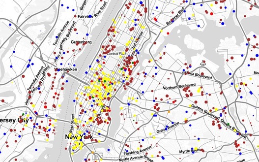
Watch the commuting patterns of New York, San Francisco and Los Angeles.

Source: www.citylab.com

This CityLab article and the embedded maps show the rhythms and patterns that make city life so beautifully complex.  The Center for Advances Spatial Analysis has compiled numerous maps, time-lapse videos and other animations to show flows of urban life.  These are great resources to visualize the ‘spaces of flows.’  

Tags: mobility, mapping, visualization, urban, planning, unit 7 cities, transportation.

Beijing’s Facelift

“A government-initiated redevelopment plan will transform one of the oldest neighborhoods in Beijing into a polished tourist attraction.”

Source: www.youtube.com

This 2010 video (and related article) showcases one of China’s urban transformation projects.  Urban revitalization plans are not without critics, especially those who see the cultural transformation of a neighborhood they deem worthy of historical preservation.  This process is occurring all over the world (we’ve recently seen this in Brazil as they were preparing for the World Cup).  This is one of the videos that I’ve put into my interactive map with over 65 geography videos to share in the classroom.
 

Developing World Cities and Population Density

Without a question, we are living in an urban era. More people now live in cities than anywhere else on the planet and I’ve repeatedly argued that cities are our most important economic engine. As a result of these shifts, we’re seeing megacities at a scale the world has never seen before.

Source: sustainablecitiescollective.com

As our cities have massively expanded in the last 70 years, so has the ecological footprint of these metropolitan areas.  This article discusses some of the challenges confronting megacities and their functions within the global urban network. 

Tags: sustainabilitydensity, megacities, housing, urban, planning, unit 7 cities. 

The Rise of Innovative Districts

“Today, innovation is taking place where people can come together, not in isolated spaces. Innovation districts are this century’s productive geography, they are both competitive places and ‘cool spaces’ and they will transform your city and metropolis.”

As described by the Brookings Institution in their exploration regarding innovation districts, they are geographic areas where leading-edge companies, research institutions, start-ups, and business incubators are located in dense proximity. These districts are created to facilitate new connections and ideas, speed up the commercialization of those ideas, and support urban economies by growing jobs in ways that leverage their distinct economic position.

Tags: density, sustainability, housing, urban, planning, unit 7 cities, labor.

innovation_districts002_16x9

Transportation and Planning

“When you combine a street and a road, you get a STROAD, one of the most dangerous and unproductive human environments. To get more for our transportation dollar, America needs an active policy of converting STROADs to productive streets or high capacity roadways.”

Seth Dixon‘s insight:

In this video, a road provides high connectivity between places, and a street is a diverse platform of social interactions that create a place.  A ‘stroad’ can be likened unto a spork–it tries to do it everything but does nothing especially well.  While you may debate the principle being shown, this video (found on Atlantic Cities) is a good way to show the spatial thinking that city planners need to utilize to improve the urban environment. 

See on www.youtube.com

Create a free website or blog at WordPress.com.

Up ↑