Search

GEOGRAPHY EDUCATION

Supporting geography educators everywhere with current digital resources.

Tag

regions

Urban world: Meeting the demographic challenge in cities

The days of easy growth in the world’s cities are over, and how they respond to demographic shifts will influence their prosperity.

Source: www.mckinsey.com

Some cities throughout Africa and Asia have experienced spectacular growth.  Europe, on the other isn’t see the same level of growth and is even experiencing urban decline in a few regions. 


Questions to Ponder: What patterns do you see in these maps?  What cultural, demographic and economic factors explain some of the regional patterns in these maps?        


What are El Niño and La Niña?

“El Niño and La Niña are complex weather patterns resulting from variations in ocean temperatures in the Equatorial Pacific–officially known as the El Niño-Southern Oscillation (ENSO) cycle. These deviations from normal surface temperatures can have large-scale impacts not only on ocean processes, but also on global weather and climate.”

Source: oceanservice.noaa.gov

This short video from NOAA is an excellent summary that explains the ENSO cycle.  The video has a particular emphasis on how changing patterns in the Pacific Ocean currents can impact weather patterns in various regions of the United States.  


Tagsphysical, weather and climateregions, USA.

Combatting FGM

“The United Nations Development Programme started to advocate against the practice of female genital mutilation (FGM) back in 2003 when it was taboo even to speak about it. In 2008, the practice was banned. The government of Egypt has institutionalized the adoption of FGM abandonment; while prevalence rates remain high (namely among older women), the response of younger girls and mothers of new generations to FGM abandonment campaigns is much higher.”

Source: www.youtube.com

This is always a difficult topic for me to talk about in my college classes since it is such a sensitive topic.  However, because it touches on so many taboo topics, that is the very reason that that practice of FGM has continued in many African and Middle Eastern countries.  See the map embedded in this article to know which countries have the highest prevalency rates.  Some are concerned that through relocation diffusion, international migrants can bring this practice to areas such as Europe. Western efforts to eradicate FGM are usually ineffective and sometimes backfire (the author in the linked articles feels that the term mutilation, while accurate, is counterproductive).


Tags: culture, gender, media

Special Economic Zones

“Special Economic Zones (SEZs) are the most rapidly spreading kind of city, having catapulted exports and growth from Mauritius and the Dominican Republic to Shenzhen and Dubai — and now across Africa. Today more than 4000 SEZs dot the planet, a major indication of our transition towards the “supply chain world” explored in Connectography.  See more maps from Connectography and order the book here.”


Tags: globalizationurban, economicindustry, regions.

Source: www.paragkhanna.com

China sends first freight train to London

Time for a long trip along the new silk road.


The train is part of Chinese President Xi Jinping’s vision for ‘One Belt, One Road’ — dubbed by some as the new silk road. It’s China’s infrastructure initiative, which Xi hopes will improve China’s economic ties with Europe, Asia and the Middle East.


Tags: regions, transportationeconomic, globalization, diffusion, industry.

Source: www.cnn.com

America’s ‘Megaregions’ using Commuter Data

New maps use math to define the amorphous term.

Source: www.citylab.com

By now I’m sure many of you have seen some iteration of this research and data visualization circulating through social media outlets (you can see the article from City Lab, Atlas Obscura or an urban planning program).  We use terms like the greater metropolitan area to express the idea that areas beyond the city boundaries and even beyond the metropolitan statistical areas are linked with cities.  These ‘mega-regions’ are in part the hinterlands of a city, a functional region where the cities act as hubs of economic regions.   

Tags: regions, urban, transportationeconomicvisualization, mapping, USA, planning.

Nine Nations of North America, 30 Years Later

“Back in the ’70s, almost a hundred reporters around the country – Washington Post bureau chiefs, rovers, freelancers and me, their desk-bound editor – were trying to get our arms around how North America worked, really. Not how it should work. But how it did work. Forget those nice neat rectangles in the middle of the U.S. Let’s be real: The mountains of western Colorado are totally alien from the wheat fields of eastern Colorado. And Miami is part not of Florida, but its own watery Caribbean realm. And what a terrible idea is ‘California.’ It behaves as if it covers three warring civilizations. The result was my 1981 book, ‘The Nine Nations of North America.’ The reader reaction was astonishing. This map – drawn to anticipate the news – revealed something much deeper. It turned out to be a map of culture and values, which have nothing to do with our perversely drawn state and national boundaries.”

Source: www.nytimes.com

Question to Ponder: How would you divide up North America?  What would be some differences from this map?  What reasons do you have for making these different regional groupings?  What are the main criteria for what constitutes a region?

Tags: regionsNorth America.

The Spice Trade’s Legacy

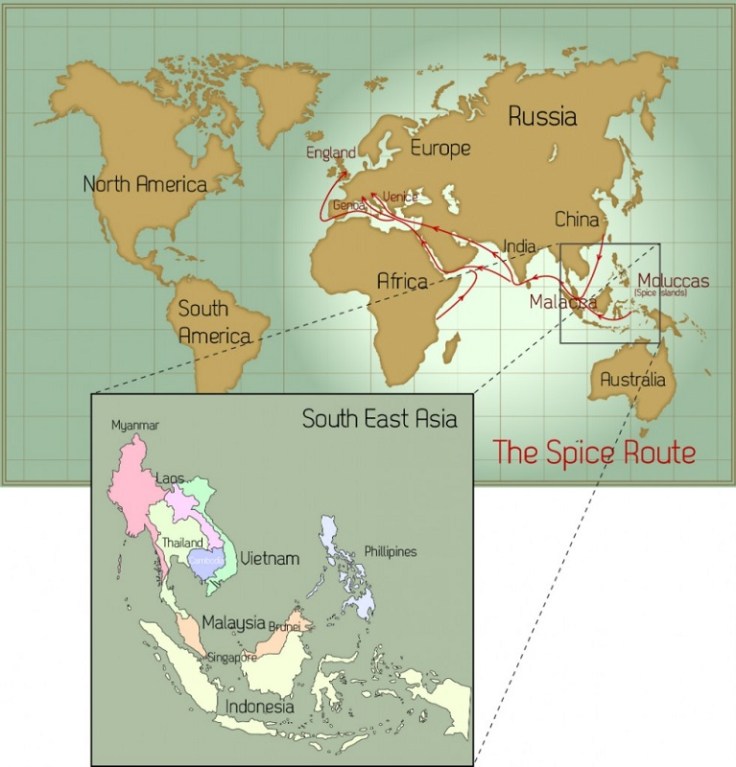
“In its day, the spice trade was the world’s biggest industry. It established and destroyed empires and helped the Europeans (who were looking for alternate routes to the east) map the globe through their discovery of new continents. What was once tightly controlled by the Arabs for centuries was now available throughout Europe with the establishment of the Ocean Spice Trade route connecting Europe directly to South Asia (India) and South East Asia.”

Source: cleanfooddirtygirl.com

The spice trade changed how we eat forever but it did so much more.  The fall of Constantinople to the Ottoman Empire cut off Europe from the vital trade routes to the east and access to the most prized commodities of the day.  What drove European exploration to get around Africa and to cross the Atlantic?  It was to reshape their situation location relative to the economic networks that shaped the emerging global economy.  In essence, the spice trade reshaped the fortunes and trajectories of several major world regions.   


Tags: Southeast Asia, food productiondiffusionglobalization, agriculture, economicindustry, economic, historical, regions.

Tornado Alley

Interested in learning about tornado alley? Then you’ll want to read our tornado alley facts and information. Tornado Alley 101

Source: www.tornadofacts.net

This map nicely shows the particular air requirements needed for a tornado to form and why the part of the United States known as Tornado Alley accounts for the majority of the world’s tornadoes.  This nicely shows how physical geographic factors form a major part of how a region might be defined and conceptualized. 


Tags: tornado, physical, weather and climate, visualization, regions.

Blog at WordPress.com.

Up ↑