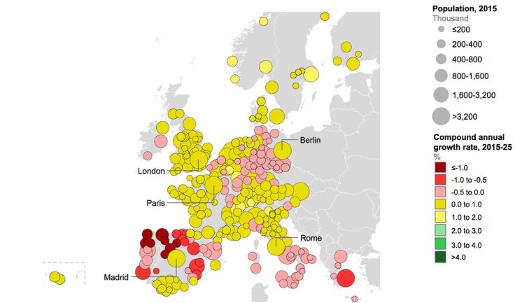
Search

GEOGRAPHY EDUCATION

Supporting geography educators everywhere with current digital resources.

Tag

urban

Water worlds: can you guess the city from the river?

Designer Alex Szabo-Haslam has stripped out the street names and highlighted the water features around 11 world cities. Can you identify them?

Source: www.theguardian.com

This is a fun map quiz that is part memory, but also relies on pattern recognition to see if you can understand the urban morphology that shaped these places. 


Tags: urbanfluvial, trivia, games.

Quiz: identify the cities from their running heatmaps

Smartphones and GPS watches now leave digital traces behind many urban runners, as they wind their way along the river or round the park. Can you identify the cities from the telltale tracks?

Source: www.theguardian.com

Last year, my running program was greatly enhanced by using a mapping app(I know, who could have guessed that Map My Run and Strava would help keep me motivated and inspired?).  More runners are naturally going to be on more important roads, but they also love beautiful parks and runs along the water.  With that in mind, can you identify these ten cities from around the world based on the density of running routes?  You can explore your city’s raw data on Strava


Tags: urbanmodelsfun, trivia.

Special Economic Zones

“Special Economic Zones (SEZs) are the most rapidly spreading kind of city, having catapulted exports and growth from Mauritius and the Dominican Republic to Shenzhen and Dubai — and now across Africa. Today more than 4000 SEZs dot the planet, a major indication of our transition towards the “supply chain world” explored in Connectography.  See more maps from Connectography and order the book here.”


Tags: globalizationurban, economicindustry, regions.

Source: www.paragkhanna.com

Providence area sees biggest shift away from manufacturing jobs in US

A new study illustrates just how drastically employment has plunged in Rhode Island’s historic industrial base over recent decades. Since 1980, the Providence metropolitan area has experienced the largest shift in the country away from manufacturing jobs and into work requiring college degrees, according to a paper by Stephan Whitaker, a research economist at the Federal Reserve Bank of Cleveland. “In 1980, 40% of workers in the Providence metro area worked in manufacturing and 25% worked in degree-intensive fields,” Whitaker writes. “By 2014, manufacturing had dropped to just 11%, and degree-intensive jobs had risen to 47%.”


Tags: urbanindustrymanufacturinglabor, economic, Rhode Island.

Source: wpri.com

Paris mayor unveils plan ​to restrict traffic and pedestrianize city center

Anne Hidalgo says she wants to cut the number of cars in French capital by half as part of campaign to tackle pollution

Source: www.theguardian.com

The world’s biggest cities are struggling to maintain access to congested downtown areas and still ensure that the downtown maintains it’s historic sense of place that generate so much tourism and concentration of cultural amenities.  Pollution is driving cities to change as the private automobile as the default mode of transportation becomes less feasible and unsustainable as cities expand to be far larger than they ever have been before.  


Tags: urban, environmentpollution, urban ecology, France, place, tourism, Paris, megacities, transportation.

The Staggering Wealth Of Mexico City

Walk on the streets and you´ll be exposed to its informal economy: people who do what they can to eke out a living including washing windshields, selling food, or even singing, dancing, and performing acrobatics for a tip.

What Americans may not know is that Mexico City is home to the wealthiest people, the poshest neighborhoods, the most exclusive shops, entertainment venues, and cultural centers on the planet.

Source: xpatnation.com

Mexico City has been the economic center of Mexico for a long time and is a true primate city. “Wealth accumulation in Mexico City has historically been concentrated in the hands of a few. In colonial times, the elite was mostly composed of Spanish-born immigrants who held high-ranking offices or worked as business owners or export-oriented merchants. Later, the wealthy were those who owned large estates known as haciendas…It is estimated that around 40 percent of Mexico’s income is owned by just 10 percent of its population, while 52.3 percent of Mexican citizens live in poverty.”


Tags: urban, megacitieseconomic, labor, Mexico.

How Jane Jacobs beat Robert Moses to be the ultimate placemaker

“Jane Jacobs lacked formal training in city planning but became an urban visionary who promoted dense, mixed-use neighborhoods where people interacted on the streets. She also became the nemesis of New York master builder Robert Moses. On our inaugural episode, we’ll explore Jacobs’ legacy and how the ideas and ideals of ‘St. Jane’ hold up today.”

Source: www.slate.com

How do you create a sense of place?  How can you make a neighborhood more vibrant and meaningful to the residents?  These are questions that central to city planners, community organizers, activists, home owners, renters, business owners, and a wide range of local stakeholders.  The Placemakers podcast has many episodes on these topics worth listening to, starting with the one about Jane Jacobs, a leading urbanist who was a proponent of “The Cheerful Hurly-Burly” of the “zoomed in” city life who fought against Robert Moses’ more sterile “zoomed out” spaces of transportation flows.  In another podcast titled “the quest for the perfect place,” the series explores new urbanism and the ideas that have shaped the movement.


Tagsplace, neighborhood, urban, planning, urbanism, podcastscale.

America’s ‘Megaregions’ using Commuter Data

New maps use math to define the amorphous term.

Source: www.citylab.com

By now I’m sure many of you have seen some iteration of this research and data visualization circulating through social media outlets (you can see the article from City Lab, Atlas Obscura or an urban planning program).  We use terms like the greater metropolitan area to express the idea that areas beyond the city boundaries and even beyond the metropolitan statistical areas are linked with cities.  These ‘mega-regions’ are in part the hinterlands of a city, a functional region where the cities act as hubs of economic regions.   

Tags: regions, urban, transportationeconomicvisualization, mapping, USA, planning.

America’s Wealth Is Staggeringly Concentrated in the Northeast Corridor

“At the county level, America is a tremendously unequal place.”

Source: www.citylab.com

The concentration of wealth within U.S. cities is one of the most powerful geographic patterns in North America (and remains of of the key geographic stories of the 2016 presidential election). NYC served as a hub for the import/export of primary economic resources during the 18th and 19th centuries as the Erie Canal opened up the interior of the United States to become part of NYC’s hinterland.  NYC expanded as a hub for the manufacturing of consumer products and then began to transition to a more tertiary based economy. “There are more than 3,000 counties in the U.S. Of the 75 with the highest incomes, 44 are located in the Northeast, including Maryland and Virginia. The corridor of metropolitan statistical areas that runs from Washington, D.C., through Baltimore, Philadelphia, New York and Boston includes 37 of these top-earning counties (where the median family takes home at least $75,000 a year).”


Tags: urbanindustrymanufacturinglabor, economic, NYC, Washington DC. Boston.

Create a free website or blog at WordPress.com.

Up ↑