Search

GEOGRAPHY EDUCATION

Supporting geography educators everywhere with current digital resources.

Month

March 2015

These twins can teach us a lot about racial identity

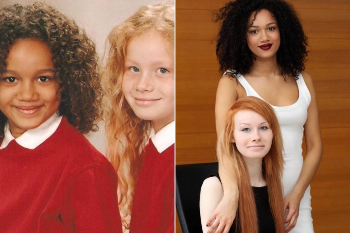
Maria says she’s black and Lucy says she’s white. Together, they prove none of this makes sense.

Source: www.vox.com

These twins also have three siblings and they say “we are at opposite ends of the [skin color] spectrum and they are all somewhere in between.”  Their lives show that the differences underlying the cultural constructs of “white” and “black” as discrete categories isn’t defensible, but it doesn’t mean that it isn’t culturally important.  As stated in the article, “here’s no question that the way people categorize Lucy and Maria, and the way they think of themselves, will affect their lives.  That’s because, even though race is highly subjective, racism and discrimination based on what people believe about race are very real.”

Tags: culturerace.

The Speed Burden [Costs of Sprawl]

The need for speed devours huge chunks of American cities and leaves the edges of the expressways worthless. Busy streets, for almost all of human history, created the greatest real estate value because they delivered customers and clients to the businesses operating there. This in turn cultivated the highest tax revenues in town, both from higher property taxes and from elevated sales taxes. But you can’t set up shop on the side of an expressway. How can cities afford to spend so much to create thoroughfares with no adjoining property value?

Source: www.originalgreen.org

That is is the ENTIRE city of Florence, Italy on the left, while there is area surrounding just one cloverleaf interchange in Atlanta, Georgia on the right.  The high speed on the highways is one of the costs of sprawl.   

Tags: transportation, planning, sprawl, scale

Augmented Reality Sandbox

“Realtime topographic contour line generation.”

Source: www.youtube.com

Many of our first experiments of creating landforms and designing a new world started in the sandbox (you can only image what I do at the beach).  This video shows how that early childhood activity can make for an excellent classroom demonstration to shows how Earth’s physical systems work.  If you don’t happen to have a digital topographic map to superimpose on the sandbox and a GPU-based water simulation, then at least you’ve got this video.  Click here to learn more about this UC Davis project on the visualization of lake ecosystems.

Tags: water, physical, geomorphology, landforms, visualization.

Teaching the Geography of Food

“Food. It’s something we all think about, talk about, and need. So how do we teach the geography of food?  In the presentation I’ll share some of my favorite resources for teaching the content as well as some pedagogical tips.  Many of these resources are found in an article on National Geographic’s website that I wrote on the topic on my personal site on a wide range of geographic issues, including food resources.

  • Tip#1: Don’t demonize agribusiness or romanticize the family farm. 
  • Tip #2: Use data and maps.  Here is a map in ArcGIS online on rural land use activities with a handy dandy instruction guide, ready to go (many more APHG GeoInquiries from ESRI set to be released soon). 
  • Tip #3: Connect them personally into the web of food systems and show how it impacts them. 
  • Tip #4: Let this be one of those units that connects to all the themes of the course, especially population, culture, political, and the environment.  

Tagsfoodeconomicfood production, agribusiness, agriculture.

Gerrymandering Visualized

By simplifying gerrymandering we see how problematic it really is.

Source: www.washingtonpost.com

The redistricting process is far from neutral; to be fair we should remember that gerrymandering is has happened on all ends of the political spectrum.  Which map do you think is the best way to divide these districts?  What is the fairest way to divide them?

Tags: gerrymandering, political, mapping, census, unit 4 political.

Robert Macfarlane on rewilding our language of landscape

For decades the leading nature writer has been collecting unusual words for landscapes and natural phenomena – from aquabob to zawn. It’s a lexicon we need to cherish in an age when a junior dictionary finds room for ‘broadband’ but has no place for ‘bluebell’

Tags: language, culture, English, toponyms, landscape.

Source: www.theguardian.com

4th Graders Get Free Admission to National Parks

The President announced yesterday that, starting in September, all 4th grade students and their families will have free access to national parks and other public lands and waters for a year.

Source: blogs.edweek.org

Field Trips in a National Park can be an incredible experience in a outstanding learning environment, but even with this incredible opportunity, it is hard to get classes and students physically the parks.  The National Park Service has produced many lesson plans, videos, distant learning programs, and resources for teachers to give them opportunities to experience the National Parks online.  These resources are available for a wide range of subjects and grade levels.  Where is the nearest U.S. National Park to your community?  


Tags: K12, virtual tours.

GeoEd on Instagram

“Fascinating combination of old urban sophistication, modern consumerism and the new spatial demands of the automobile. Spotted in Washington D.C., on the corner of 10th and G.”

Source: instagram.com

So apparently Instagram’s a thing.  Anyway, I created an account to share some on the physical and cultural landscapes that I find intriguing. 

I also curate other pages on scoop.it including:

Cultural Geography

Regional Geography

Fantastic Maps

History and Social Studies Education

and the

Social Media Classroom


Can India become a superpower?

Source: www.youtube.com

India is a land filled will problems and potential, due its geographic context.  This regions is great for a regional geography course, that also includes a good overview of the entire South Asian region before discussing India’s political situation in global affairs. 

Tagsdevelopment, India, South Asia, geopolitics.

Create a free website or blog at WordPress.com.

Up ↑