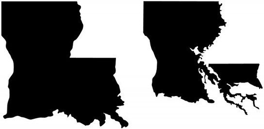
Unlike the many maps we have seen that show what Florida, Boston, or some other coastal location would look like with higher sea levels, the figure above compares the iconic outline of Louisiana with the present-day outline of its dry land. An important caveat is that some of the removed areas are wetlands, meaning they are not under water all the time, but those lands are not available for most human uses (aside from fishing), so this outline warrants attention.
Source: environmentalgeography.blogspot.com
Last month I was in New Orleans, Louisiana and I’m so disheartened to know that thousands have their homes under water. As stated in this article, “the boot is at best an inaccurate approximation of Louisiana’s true shape and, at worst, an irresponsible lie.” To explore the issue yourself, this gorgeous interactive map pulls together some high quality source materials on a wide range of issues to look at this environmental issues of this region in a holistic manner.
Tags: environment, weather and climate, coastal, water, disasters.


Leave a comment