“The Story Map Swipe and Spyglass app template enables users to interact with two web maps or two layers of a single web map, depending on how you build your story. The app enables you to present a single view, or to develop a narrative showing a series of locations or views of the same maps.”
Source: storymaps.arcgis.com
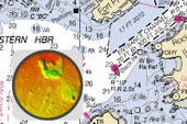
The ESRI template to create swipe and spyglass feature is an engaging way to compare and contrast two data layers. For the SPYGLASS maps, I’ve always enjoyed this historical interactive of Chicago. Chicago is displaced during a economic boom period as the U.S. was expanding westward. Where were the railroads located then? Why have some of them vanished today? Notice anything curious about the coastline along Lake Michigan? Follow this link to see similar interactives of other major U.S. cities.
For the SWIPE maps, I love exploring this one showing how human activities has reshaped the physical environment. What activities are creating the new patterns that you see?
Tags: historical, mapping, ESRI, StoryMap.


Leave a comment