Search

GEOGRAPHY EDUCATION

Supporting geography educators everywhere with current digital resources.

Author

sethdixon

I am a geography professor at Rhode Island College.

New Images Show China Literally Gaining Ground in South China Sea

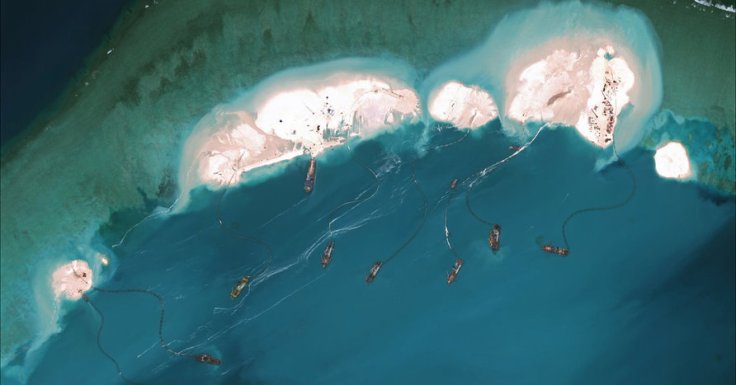
Satellite photos show the speed, scale and ambition China has exerted to assert ownership over South China Sea islands, far from the mainland.

Source: www.nytimes.com

In addition to the original BBC article, here is another article from the Telegraph with some aerial imagery showing the extent of this geo-engineering project.  This has plenty of geopolitical implications and the United States government is on record saying that it is “concerned.”


Questions to Ponder:  Why is China building up this island?  What advantage would that give them?  Why aren’t other countries with competing claims stopping China?


Tags: borders, political, conflict, waterChina, East Asia.

The United States’ Geographic Situation

The Greater Mississippi Basin is the United States’ core and serves as the underpinning of its role as a global superpower. For more analysis, visit: http://...

Source: www.youtube.com

I wouldn’t use the word “core” to describe America’s breadbasket, simply because of the economic core/periphery connotations.  Other than that, this video highlights some aspects of U.S. regional geography that I cover ever semester.  1) The United States is bi-coastal on the two most important oceans for global trade.  2) Between those coasts is a large agricultural region overlayed on the most navigable river network.  These two basic facts go a long way in explaining the United States’ position in global affairs.

Tags: USA. regions.

15 before-and-after images that show how we’re transforming the planet

We’ve dammed mighty rivers, built hundreds of artificial islands, and made the world’s fourth-largest lake disappear.

Source: www.vox.com

This article highlights 15 classroom-ready examples of environmental change that can readily detected with satellite imagery.   See these 25 from NASA’s Earth Observatory.

Tags: remote sensing, land use, environment, geospatial, environment modify, unit 1 Geoprinciples.

Nicaragua’s Controversial Canal

The proposed Nicaragua Canal could be one of the largest engineering projects in history and promises to bring thousands of jobs to the impoverished country. But the government’s secretive deal with a Chinese-led firm has some Nicaraguans raising the alarm about displacement and environmental destruction in the canal’s path.

Source: www.youtube.com

I’m fascinated by massive geo-engineering projects.  Usually, the proponents of the project will support it claiming that by reconfiguring the geographic settings it will lead to the economic growth of the country and strengthen their political situation.  This proposed canal in Nicaragua has many supporters and detractors.  Opponents cite that traditional land use patterns will get disrupted, the poor will be displaced, and the environment will be degraded. This canal is not so very different from many other geo-engineering projects in that respect.


Tags: transportation, Nicaragua, globalization, industry, economic, environment, political, resourcespolitical ecology.

Maeklong Railway Market

“Multi-purpose land use.”

Source: www.youtube.com

There are many videos online showing the Maeklong Railway Market, but I’ll share just a few. Clearly the 8 times a day runs like clockwork for the vendors, but as this other video shows, the 8 times a day that the trains go through the market an it becomes a tourist attraction. My students are usually quite shocked to see how this city market in Thailand operates and this video is a usefully ‘hook’ for lesson on population growth, urbanization, economic development, sustainability, megacities and city planning. 


Questions to Ponder: Why does this system work in Thailand, but is inconceivable for the United States?  How many spaces are single use spaces that remain empty most of the day?  How does the both the train line and the market need to accommodate the other? 


Tags: Thailand, Southeast Asiaurbanland use, megacitiesdevelopment, density, sustainability, planning.

California Drought Tests History of Endless Growth

A punishing drought is forcing a reconsideration of whether the aspiration of untrammeled growth that has for so long been the state’s engine has run against the limits of nature.

Source: www.nytimes.com

Major urban areas in California have limited local water resources so they draw water from large area to bring in sufficient water for these burgeoning metropolitan regions.  With this current drought getting worse, California has ordered emergency water restrictions on residents while companies and large farms have been granted exemptions even though they account for 82% of the state’s annual water consumption (residential accounts for 12%). Almond farms alone consume 10% of the state’s water, or as much as entire city of Los Angeles.


Questions to Ponder: How does the concept of carrying capacity relate to California urban growth/drought issues?  California passed its carrying capacity?  How are demographics, economics, politics and the environment intertwined in California?  What are the environmental limits on urban growth and development? 

Tags: physical, weather and climate, consumptionCalifornia, water, environment, resources, environment dependurban ecology.

Cultural Code-Switching

“The way we mix languages and speech patterns is an apt metaphor for the way race, ethnicity and culture intersect in our lives.”

Source: www.npr.org

Who we are, and how we behave is often dependent on the the circumstances and the cultural norms that govern those situations, places and relationships.  All of us, including President Obama, fit into many distinct cultural environments and the picture above shows a quick moment, when he can slip in and out of cultural settings (this was spoofed by Key and Peele). 

Questions to Ponder: When do you ‘code switch‘ and how come?  What does this mean for society at large and for the intersecting cultural groups with which we personally might identify?  When is this being fake or culturally inauthentic? 

Tags: culturelanguage, race, unit 3 culture.

Japan’s Disappearing Villages

In the small town of Nagoro, population 35, one woman is trying to save her village from extinction by creating life-sized dolls for every inhabitant who either dies or moves away.

Source: www.foreignaffairs.com

Japan has experienced rural to urban migration for decades now; simultaneously, Japan’s fertility rates have dropped far below replacement level.  While Tokyo is still bustling, small villages are shrinking to the point of disappearing.  This is a haunting and yet touching tribute to these emerging ghost towns.  It seems like a memorial to enshrine a sense of place before the memory of this place is forever eradicated–like a an earthen dam .  


Tags: Japan, declining population, population, demographics, unit 2 population, East Asialandscape, place.

Countries in multiple hemispheres

Source: www.worldatlas.com

The equator is a great circle that bisects the Earth into equal halves commonly referred to as the Northern and Southern hemispheres.  The map above shows a few of the countries that straddle the Eastern and Western hemispheres as defined by two important lines, the Prime Meridian and the 180th Meridian.  Now, only ONE COUNTRY is in all four hemispheres as defined by these great circles...any guesses before searching? 

ACTIVITY: A fellow geographer shared with me that he had a map from an old atlas showing latitudes as is typically presented but the lines of longitudes along the top and the bottom were based on two different systems. Greenwich was becoming the standard at the time it was printed, but this U.S.-published map also references longitude from Washington D.C. as the Prime Meridian.   So a fun classroom exercise would be to count multiple-hemisphere countries with DC set to 0 degrees. This can be repeated for any other city or landmark.

SPECIAL TRIVIA BONUS: That previous trivia fact is about as geo-nerdy as knowing what 2 countries in the world are double landlocked.  

Tags: fun, trivia.

Create a free website or blog at WordPress.com.

Up ↑