Search

GEOGRAPHY EDUCATION

Supporting geography educators everywhere with current digital resources.

Author

sethdixon

I am a geography professor at Rhode Island College.

How Ebola sped out of control

The story behind the failure of the world’s health organizations to stop the Ebola disaster.

Source: www.washingtonpost.com

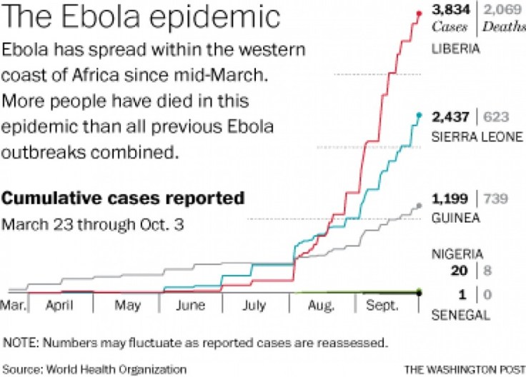
We have witnessed the terrifying dispersal of the Ebola virus in West Africa.  Cultural practices have facilitated the spread of Ebola in West Africa, and a distinct set of cultural practices is one reason why many experts do not expect it to spread in the United States.   The videos in this TIME article answer some basic questions about how the disease is spread while this data interactive has a useful timeline, map and charts to show the data behind the outbreak.  


Tags: Ebola, medical, development, diffusion, Africa.

Where Has All the Water Gone?

“Once the fourth-largest lake in the world, Central Asia’s shrinking Aral Sea has reached a new low, thanks to decades-old water diversions and a more recent drought.” 

Source: blog.education.nationalgeographic.com

I have posted many times in the past about the Aral Sea, but this recent event has been the most dramatic update in years.  The Eastern portion of the lake has been receding for decades, but it is now officially gone.  This fantastic set of satellite images of the region painfully chronicles the decline of the Aral Sea as irrigation in the region diverted all the sources of the lake.   

Tags: environment, Central Asia, environment modify.

Flooding Risk From Climate Change, Country by Country

A new analysis of sea levels and flood risk around the world offers more evidence that the brunt of climate change will not be borne equally.

More than a quarter of Vietnam’s residents live in areas likely to be subject to regular floods by the end of the century.  Globally, eight of the 10 large countries most at risk are in Asia.  These figures are the result of a new analysis of sea levels and flood risk around the world, conducted by Climate Central and based on more detailed sea-level data than has previously been available.  The analysis offers more evidence that the countries emitting the most carbon aren’t necessarily the ones that will bear the brunt of climate change.  

Tags: Southeast Asia, water, disasters, urban ecology, coastalclimate change

Source: www.nytimes.com

World Record Mapping Event

Join our FREE GIS Day World Record mapping event taking place during Geography Awareness week (Nov 17th -21nd 2014, video with more details).  With a local to global perspective, we want students to map their thoughts and feeling about their local area.


They can add their data to a global map that is shared with the world. Help us achieve our goal of having 100,000 students take part globally.  The event will provide great opportunities for:


  • Using the latest GIS technology
  • Spatial thinking
  • Data analysis with GIS
  • Map design
  • Connecting students with their peers worldwide

Tagsmapping, GIS K12, ESRI, geospatial, edtech.


Source: esriukeducation.maps.arcgis.com

World’s Largest Dam Removal Unleashes U.S. River After Century of Electric Production

The last section of dam is being blasted from the Elwha River on Washington’s Olympic Peninsula on Tuesday.

For almost half a century, the two dams were widely applauded for powering the growth of the peninsula and its primary industry. But the dams blocked salmon migration up the Elwha, devastating its fish and shellfish—and the livelihood of the Lower Elwha Klallam tribe. As the tribe slowly gained political power—it won federal recognition in 1968—it and other tribes began to protest the loss of the fishing rights promised to them by federal treaty in the mid-1800s. In 1979, the U.S. Supreme Court ruled that Washington tribes, including the Elwha Klallam, were entitled to half the salmon catch in the state.

Source: news.nationalgeographic.com

See also this video to see the rapid changes on the nearby White Salmon River when they removed the dam. 

Tags: biogeography, environment, land use, sustainability, environment adapt.

Beautiful Physical Landscapes

“#TheRidge is the brand new film from Danny Macaskill… For the first time in one of his films Danny climbs aboard a mountain bike and returns to his native home of the Isle of Skye in Scotland to take on a death-defying ride along the notorious Cuillin Ridgeline.”

Source: www.youtube.com

I loved Danny Macaskill’s earlier video in Scotland’s cultural landscapes, and this extreme sports clip is infused with gorgeous physical landscapes.


Tag: Scotland, sport, landscape.

Media and Culture–Perspective and Bias

“Religious scholar Reza Aslan took some serious issue on CNN Monday night with Bill Maher‘s commentary about Islamic violence and oppression. Maher ended his show last Friday by going after liberals for being silent about the violence and oppression that goes on in Muslim nations. Aslan said on CNN that Maher’s arguments are just very unsophisticated.  He said these ‘facile arguments’ might sound good, but not all Muslim nations are the same. Aslan explained that female mutilation is an African problem, not a Muslim one, and there are Muslim-majority nations where women are treated better and there are even female leaders.”

Source: www.youtube.com

Question to Ponder: How does the media play a role in shaping the conversations we have in society about different cultures and places?  How can ‘painting with a broad brush’ lead to stereotypes and inaccurate conclusions?  

Tagsplaceregions, culture religion, Middle East, media.

The Most Complex International Borders in the World

“In this video I look at some of the most complex international border. Of course, there are more complex borders in the world, but this video looks at some of my favourites.”

Source: www.youtube.com

This video shows some great examples of how the political organization of space and administration of borders can get complicated.  Here are the examples (and time in the video when they are covered in the video):


Tags: borders, political, territoriality, sovereignty, video.


50 Years Ago, A Fluid Border Made The U.S. 1 Square Mile Smaller

Since Texas became a state, the Rio Grande has marked the border between the U.S. and Mexico. But, like rivers do, it moved. In 1964, the U.S. finally gave back 437 acres of land.

Ever since Texas became a state, the river has been the border between the two countries. But rivers can move — and that’s exactly what happened in 1864, when torrential rains caused it to jump its banks and go south. Suddenly the border was in a different place, and Texas had gained 700 acres of land called the Chamizal (pronounced chah-mee-ZAHL), so named for a type of plant that grew there.

Tags: Mexico, migration, borders, political, place, podcast.   

Source: www.npr.org

Create a free website or blog at WordPress.com.

Up ↑