Search

GEOGRAPHY EDUCATION

Supporting geography educators everywhere with current digital resources.

Author

sethdixon

I am a geography professor at Rhode Island College.

Beijing’s Facelift

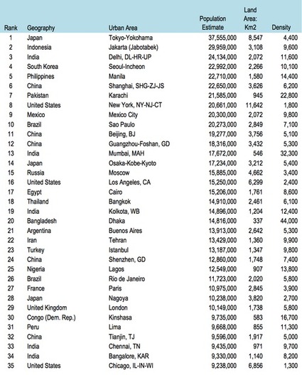
“A government-initiated redevelopment plan will transform one of the oldest neighborhoods in Beijing into a polished tourist attraction.”

Source: www.youtube.com

This 2010 video (and related article) showcases one of China’s urban transformation projects.  Urban revitalization plans are not without critics, especially those who see the cultural transformation of a neighborhood they deem worthy of historical preservation.  This process is occurring all over the world (we’ve recently seen this in Brazil as they were preparing for the World Cup).  This is one of the videos that I’ve put into my interactive map with over 65 geography videos to share in the classroom.
 

Developing World Cities and Population Density

Without a question, we are living in an urban era. More people now live in cities than anywhere else on the planet and I’ve repeatedly argued that cities are our most important economic engine. As a result of these shifts, we’re seeing megacities at a scale the world has never seen before.

Source: sustainablecitiescollective.com

As our cities have massively expanded in the last 70 years, so has the ecological footprint of these metropolitan areas.  This article discusses some of the challenges confronting megacities and their functions within the global urban network. 

Tags: sustainabilitydensity, megacities, housing, urban, planning, unit 7 cities. 

China’s territorial claims

One of the geography videos embedded in this interactive map: http://bit.ly/KDY6C2

Source: www.youtube.com

Suspicions between the People’s Republic of China and its neighbors bedevil its boundaries to the east, south and west as shown in this videographic from the Economist.  This is one of the videos that I’ve put into my interactive map with over 65 geography videos to share in the classroom

Tags: borders, political, conflict, waterChina, East Asia.

America’s recent drought history, animated

“California’s drought just hit a new milestone: As of this week, 32.98 percent of the state is experiencing “exceptional” drought, making it the worst drought in the 14 years that the Department of Agriculture’s Drought Monitor has tracked data.”

Source: www.washingtonpost.com

The recent drought in California has only deepened and this Washington Post article shows an animated map that highlights the temporal and spatial patterns in the drought data (hint–it’s not pretty).  In a related note, May 2014 was the hottest May in recorded history.     

Questions to Consider: What are some reasons (both from human and physical geography) for this severe drought? What can be done in the short-term to lessen the problem? What can be done to make California’s water situation better for the next 50 years?

Tags: physical, weather and climate, consumptionCalifornia, water, environment, resources, environment dependurban ecology.

Observations from the 2014 APHG Reading

Once again the AP Human Geography reading was a success. I still firmly believe that this group pf 500+ teachers and professors have GOT to be the most extraordinary and interesting people than any…

Source: www.thehumanimprint.com

This article (with an outstanding infographic) from the Human Imprint is an excellent summary of the AP Human Geography reading and gives some valuable insights to prepare students to pass the exam.  This is well worth the read for any APHG teacher.    


TagsAPHG, infographic.

Malaysia’s ‘Allah’ controversy

Is limiting the use of the Arabic word for God a sign of growing intolerance towards minorities?

Source: stream.aljazeera.com

In Arabic, the word Allah means God.  Christian Arabs refer to God as Allah and Arabic versions of the Bible reference Allah.  As Arabic and Islam have diffused in interwoven patterns, the linguistic root and the theological meanings have became intertwined to some.  BBC World and Al-Jazeera have reported on this issue as the Malaysian government has attempted to ban the use of the word Allah to any non-Muslim religious group.  Language and religion just got very political.  

Tags: languagereligion, political, Malaysia, SouthEastAsia, culture, Islam.

Lies Your World Map Told You: 5 Ways You’re Being Misled

“Unfortunately, most world political maps aren’t telling you the whole story. The idea that the earth’s land is cleanly divvied up into nation-states – one country for each of the world’s peoples – is more an imaginative ideal than a reality. Read on to learn about five ways your map is lying to you about borders, territories, and even the roster of the world’s countries.”

Source: www.polgeonow.com

This is a nice article to get students to look past the officialness of a world map to explore some of the complexities that make contemporary political geography so compelling.  In a nutshell, this article discusses 5 major themes:

  1. Missing countries
  2. Incomplete control
  3. Undefined borders
  4. Disputed territories
  5. Territorial seas

Tags: bordersmapping, political, territoriality, sovereignty.

African borders

“About the history of the creation of Africa borders and debates about African borders.”

Source: mycontinent.co

Disregard the rough English grammar; this is a nice article to show some of the historical, ethnic, linguistic and political complexities behind African borders.  This would be a great supplemental article to help AP Human Geography students to prepare for Question 2 of the 2014 AP Human Geography Exam that focused on superimposed boundaries within an African context.  

TagsAPHG, language, Africa, colonialism, borders, political.

The Rise of Innovative Districts

“Today, innovation is taking place where people can come together, not in isolated spaces. Innovation districts are this century’s productive geography, they are both competitive places and ‘cool spaces’ and they will transform your city and metropolis.”

As described by the Brookings Institution in their exploration regarding innovation districts, they are geographic areas where leading-edge companies, research institutions, start-ups, and business incubators are located in dense proximity. These districts are created to facilitate new connections and ideas, speed up the commercialization of those ideas, and support urban economies by growing jobs in ways that leverage their distinct economic position.

Tags: density, sustainability, housing, urban, planning, unit 7 cities, labor.

innovation_districts002_16x9

Create a free website or blog at WordPress.com.

Up ↑