Search

GEOGRAPHY EDUCATION

Supporting geography educators everywhere with current digital resources.

Author

sethdixon

I am a geography professor at Rhode Island College.

The world’s oldest living tree

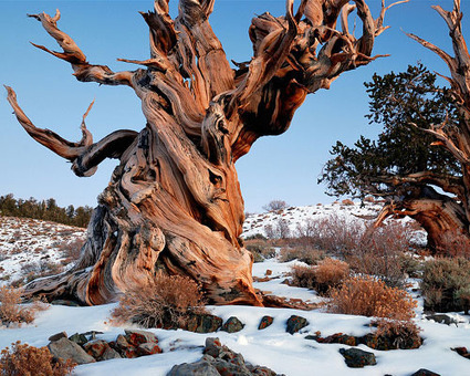
At 4,841 years old, this ancient bristlecone pine is the oldest known non-clonal organism on Earth. Located in the White Mountains of California, in Inyo National Forest, Methuselah’s exact location is kept a close secret in order to protect it from the public. (An older specimen named Prometheus, which was about 4,900 years old, was cut down by a researcher in 1964 with the U.S. Forest Service’s permission.) Today you can visit the grove where Methuselah hides, but you’ll have to guess at which tree it is. Could this one be it?

Seth Dixon‘s insight:

I freely admit that I have a strange fascination with the twists and turns in a majestic tree; I find that they are great reminders of the wonders and beauty to be found on Earth. 

Tags: biogeography, environmentecology, historical, California.

See on www.mnn.com

Gravity…

“The video clip shows the cliff where the fall initiated, near the ledge close to the skyline.  Then, below the ledge, you can see the talus cone, which are rocky bits along the slope. The really large boulders that fell down and ruined the house have carved out soil ruts as the boulders rolled downhill.”

Seth Dixon‘s insight:

I found this video on GEOMORPHOLOGY ROCKS‘ (get it?) Facebook page, a good follow for physical geography resources.  On January 21, 2014 in Termeno, Italy (South Tyrol) a massive rockfall disrupted the agricultural landscape that sits in the shadow of the Alps.  The video below shows the impacts of the rockfall and powerfully highlights that natural forces are always in motion.  

Rockfall

Sinkholes and Karst Topography


The above YouTube clip was embedded in this LiveScience article: “Sinkholes are an increasingly deadly risk in Florida, due primarily to the region’s geology. The state is largely underlain by porous limestone, which can hold immense amounts of water in underground aquifers. As groundwater slowly flows through the limestone, it forms a landscape called karst, known for features like caves, springs and sinkholes.

The water in aquifers also exerts pressure on the limestone and helps to stabilize the overlying surface layer, usually clay, silt and sand in Florida. Sinkholes form when that layer of surface material caves in.

The collapse can be triggered by a heavy overload, often caused by a downpour or flooding, or when water gets pumped out of the ground.”

See on www.youtube.com

Oil Pirates and the Mystery Ship

“Forget Somalia, the world’s new epicenter of piracy is on the other side of Africa.”

Some experts believe that the uptick in the number and geographical reach of pirate attacks is due in part precisely to the 2009 government amnesty for the Nigerian militants in the Niger Delta who had justified their attacks on oil infrastructure and their widespread theft of crude oil as a political protest. “With the political pretense lost, there is no longer any need for oil thieves to limit themselves to targets in the Delta,” a United Nations study said.

See on www.foreignpolicy.com

What Everybody From The North Needs To Understand About The Traffic Disaster In Atlanta

“Republicans want to blame government (a Democrat thing) or Atlanta (definitely a Democrat thing). Democrats want to blame the region’s dependence on cars (a Republican thing), the state government (Republicans), and many of the transplants from more liberal, urban places feel the same way you might about white, rural, southern drivers. All of this is true to some extent but none of it is helpful.”

Seth Dixon‘s insight:

There are no easy answers, but that doesn’t mean we people aren’t trying to frame this in an easy narrative.  

See on www.businessinsider.com

Historical Metropolitan Populations of the United States

“The graph and tables on this page attempt to show how the urban hierarchy of the United States has developed over time. The statistic used here is the population of the metropolitan area (contiguous urbanized area surrounding a central city), not the population of an individual city. Metropolitan area population is much more useful than city population as an indicator of the size and importance of a city, since the official boundaries of a city are usually arbitrary and often do not include vast suburban areas. For example, in 2000 San Antonio was the 10th largest city in the U.S., larger than Boston or San Francisco, but its Metro Area was only ranked about 30th. The same thing was happening even back in 1790: New York was the biggest single city, but Philadelphia plus its suburbs of Northern Liberties and Southwark made it the biggest metro area.”

See on www.peakbagger.com

How Vietnam became a coffee giant

“Think of coffee and you will probably think of Brazil, Colombia, or maybe Ethiopia. But the world’s second largest exporter today is Vietnam. How did its market share jump from 0.1% to 20% in just 30 years, and how has this rapid change affected the country?”

Seth Dixon‘s insight:

Vietnam is a historically tea-drinking country, and when the French colonized, they brought coffee.  Culturally they still prefer tea, but in the 1980s, the government say this as a major export crop that they were climatically primed to produce.  This rapid growth has bolstered the economy, but has had some adverse environmental impacts as well.  The article is rich in geographic topics to bring into the classroom.

Tags: Vietnamagricultureglobalization, SouthEastAsia.

See on www.bbc.co.uk

The States of Our Union … Are Not All Strong

“On Tuesday, President Obama, if precedent holds, will declare that the state of America’s union is ‘strong.’ Is it?” 

Politico Magazine rounded up 14 different state rankings from reputable sources like the Census Bureau, the Centers for Disease Control and Prevention, and the FBI, and on important factors such as high school graduation rates, per capita income, life expectancy and crime rate. Then we averaged out each state’s 14 rankings to come up with a master list—atop which sits none other than New Hampshire. The approach isn’t scientific or comprehensive (we also hold no grudges against the State of Mississippi), but given that eight of the lowest-ranking states on our list overlap with the bottom 10 on his, maybe less has changed in the past 83 years than you’d think.

See on www.politico.com

A short, recent history of Congo

Mapping the war in Congo: mineral wealth, militias and an epic march

Seth Dixon‘s insight:

To understand much of the political situation in Central Africa, a short history of the recent political and ethnic turmoil in Rwanda and Congo are helpful.  This particular videographic from the Economist is a few years old, but the historical context is still incredibly relevant  This series provides a wealth of information and several will be added to the place-based geography videos interactive map.

Tags: Congo, political, conflict, devolution, refugees, Africa.

See on www.youtube.com

Congo

Create a free website or blog at WordPress.com.

Up ↑