Hans Rosling explains a very common misunderstanding about the world. CC by www.gapminder.org
Seth Dixon‘s insight:
See on www.youtube.com
Hans Rosling explains a very common misunderstanding about the world. CC by www.gapminder.org
See on www.youtube.com
Twenty kilometers (12 miles) from England’s Kent and Essex coasts, the world’s largest offshore wind farm has started harvesting the breezes over the sea. Located in the Thames Estuary, where the River Thames meets the North Sea, the London Array has a maximum generating power of 630 megawatts (MW), enough to supply as many as 500,000 homes.
The wind farm became fully operational on April 8, 2013. Twenty days later, the Operational Land Imager (OLI) on the Landsat 8 satellite captured this image of the area. The second image is a closeup of the area marked by the white box in the top image. White points in the second image are the wind turbines; a few boat wakes are also visible. The sea is discolored by light tan sediment—spring runoff washed out by the Thames.
See on earthobservatory.nasa.gov
“One of our colleagues and leaders in spatial thinking in education, Dr. Diana Stuart Sinton, has written a book entitled The People’s Guide to Spatial Thinking, along with colleagues Sarah Bednarz, Phil Gersmehl, Robert Kolvoord, and David Uttal. As the name implies, the book provides an accessible and readable way for students, educators, and even the general public to understand what spatial thinking is and why it matters. It “help[s] us think across the geographies of our life spaces, physical and social spaces, and intellectual space.” Dr. Sinton pulls selections from the NRC’s Learning to Think Spatially report and ties them to everyday life. In so doing, she also provides ways for us in the educational community to think about teaching these concepts and skills in a variety of courses. Indeed, as she points out, spatial thinking is particularly essential within science, technology, engineering, and mathematics, as well as geography.” – See more at: ESRI’s GIS Education Community blog.
See on blogs.esri.com
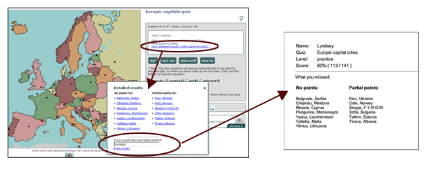
For Regional Geography, I ask that all my students take online quizzes before coming to class because it is very difficult to intelligently discuss European issues if you don’t know the countries of Europe, where they are and what other countries are on their borders. Quizzes and knowing places doesn’t define geography, but if geography were English literature, knowing about places could be described as the alphabet–before you write a sonnet or critique an essay, you better know your ABC’s and basic grammar. Given that, I like the Lizard Point Geography quizzes, Sheppard Software quizzes and those from Click that ‘Hood; they are simple, straightforward and comprehensive. Below is a YouTube video that shows how to take the Lizard Point quizzes.

Throughout the semester, you will need to collect these images as screenshots (use the snipping tool or print screen function) to turn in as proof that you took the quizzes. You can also grab a screenshot of your results on Click that ‘Hood (without your name, but with a time).
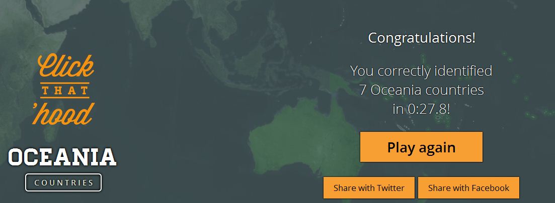
During the course of the semester in World Regional Geography, you should complete all of the following quizzes (and 9 more for a total of 20 quizzes):
See on geographyeducation.org
“A fisherman’s cottage is described by real estate agents as a ‘property not to be missed’ but it is also just yards away from two nuclear power stations.”
A photograph (or landscape, map, etc.) is not an innocent reflection of reality. They can be carefully crafted to tell a story which might reflect the bigger picture and your ideological framework–but it just as easily might obscure some important contexts and truths. I use these images at the beginning of the semester to discuss the bias inherent in our own perspectives as I try to infuse my classroom with a variety of lenses with which to view different regions (images found here).
Tags: images, landscape, perspective, regions.
See on www.telegraph.co.uk
Explore a global timelapse of our planet, constructed from Landsat satellite imagery. With water diverted to irrigation, the inland Aral Sea has shrunk drama…
The collapse of the Aral Sea ecosystem is (arguably) the worst man-made environmental disaster of the 20th century and 21st century has seen the desertification continue. Soviet mismanagement, water-intensive cotton production and population growth have all contributed the overtaxing of water resources in the Aral Sea basin, which has resulted in the shrinking of the Aral Sea–it has lost more of the sea to an expanding desert than the territories of the Netherlands, Belgium and Luxembourg combined. The health problems arising from this issues are large for the entire Aral Sea basin, which encompasses 5 Central Asian countries and it has profoundly changed (for the worse) the local climates. Compare the differences with some historical images of the Aral Sea on Google Earth or on ArcGIS Online (also see this article from GeoCurrents).
Tags: environment, Central Asia, environment modify.
See on www.youtube.com
Thirty years ago, the states with the deepest poverty were all clustered in dixie. But the rest of the country has been playing catchup.
So how did poverty stop being a Southern specialty? You’ve had, deindustrialization in the Midwest and Northeast. And you’ve had fast growing Hispanic populations, which tend to be poorer, in California, Nevada, Arizona, and Colorado (as well as North Carolina and Georgia, which could explain their presence on the list above). Meanwhile, the Southeast has made some economic progress by attracting foreign manufacturing, among other efforts.
See on www.theatlantic.com
“In Raleigh, N.C., there’s a house… or what looks like a house. What’s hidden inside is more important than most people realize. Read the story: http://wunc.org/post/video-whats-inside-house-wade-avenue ”
What looks like a wonderful little “Scooby-Doo” mystery turns out to be a great lesson on city planning, land use and utilities (I don’t want to ruin the surprise that comes at the 2 minute mark, but don’t worry, it’s worth it). If you are teaching a course trying to help students to think about the inner-workings of a city this article would be a very attention grabbing way to make a good point. What ‘secrets’ are hidden in plain sight in your local neighborhood?
See on www.youtube.com