Search

GEOGRAPHY EDUCATION

Supporting geography educators everywhere with current digital resources.

Author

sethdixon

I am a geography professor at Rhode Island College.

Place-based Geography Videos

Professor Seth Dixon shares over 50 of his favorite geography videos to share in the classroom http://bit.ly/KDY6C2

Seth Dixon‘s insight:

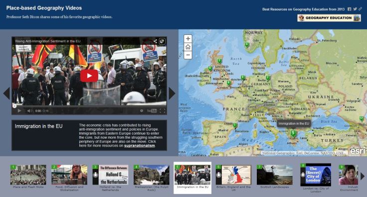
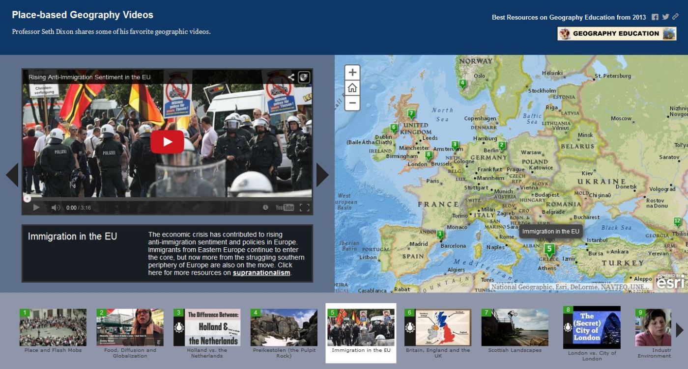
Have you ever wanted to watch a video and to have a map handy at the same time?  Ever since I first watched Raiders of the Lost Ark, I love the idea of combining video with maps.  I produced this bare-bones map on ArcGIS online to spatially index over 50 videos that I enjoy using in my classes; they are all place-specific videos (so they can be ‘located’ on the map).  These videos have been shared here earlier, but this map can function as a more user-friendly way to search for engaging video clips.  Do you have a great place-based video that teaches principles of geography that you love?  Please share the URL in the comments section with a brief paragraph. 

Tags: mapping, video, ESRIgeography education.

See on www.arcgis.com

VIDEO MAP TOUR

Transportation and Planning

“When you combine a street and a road, you get a STROAD, one of the most dangerous and unproductive human environments. To get more for our transportation dollar, America needs an active policy of converting STROADs to productive streets or high capacity roadways.”

Seth Dixon‘s insight:

In this video, a road provides high connectivity between places, and a street is a diverse platform of social interactions that create a place.  A ‘stroad’ can be likened unto a spork–it tries to do it everything but does nothing especially well.  While you may debate the principle being shown, this video (found on Atlantic Cities) is a good way to show the spatial thinking that city planners need to utilize to improve the urban environment. 

See on www.youtube.com

“Lost” New England Revealed

“New England’s woody hills and dales hide a secret—they weren’t always forested. Instead, many were once covered with colonial roads and farmsteads.

Seth Dixon‘s insight:

I love living in New England and finding stone walls from old farmsteads; an archaeology professor at UConn is using geospatial technologies to map out the remants of that historical landscape.  This is a great example of using spatial thinking across the disciplines. 

Tags: remote sensing, geospatiallandscape, historical, environment modify.

See on news.nationalgeographic.com

Population by Latitude and Longitude

Radical Cartography, brought to you by Bill Rankin

Seth Dixon‘s insight:

I was recently reminded of the graph and thought is was world sharing again.  This is an excellent spatial graph that helps to explain the distribution of the human population.  Why do we live where we live?   The longitude map is still fascinating, but has less explanatory power.  What would be brilliant is a graph that charted population by latitude (as this does) AND charts the amount of land at each given latitude.  Click here for Frank Jacobs analysis on the “Strange Maps” blog.   

See on www.radicalcartography.net

Global wind conditions

an animated map of global wind conditions

Seth Dixon‘s insight:

Earlier I shared a dynamic map of near-live wind data for the United States and a static rendering of global wind patterns.  This combines the features of both of those resources to provide a mesmerizing digital globe.  Click on the ‘earth’ icon in the lower righthand corner to customize the display.  

See on earth.nullschool.net

‘I would love to teach but…’

‘Education cannot be objectively measured…

Seth Dixon‘s insight:

I love being an educator, but many educators I know are very jaded about the system and all the ‘other junk’ that gets in the way of them doing what they truly love.  This is an insightful critique of problems in the system today that make educators want to pull their hair out.  I’m not giving up, but that doesn’t mean I think that the system is wonderful for students, teachers or parents. 

See on www.washingtonpost.com

An astonishing, dangerous cold snap is about to descend on the U.S.

Some of the coldest air in years, if not decades, is poised to pour into the U.S., with mind-boggling low temperatures.

Seth Dixon‘s insight:

Why is it going to be so cold in much of the Northeartern part of the United States?  Physical geography, that’s why. 

See on www.washingtonpost.com

Are Elvish, Klingon, Dothraki and Na’vi real languages?

View full lesson on TED-ED: What do Game of Thrones’ Dothraki, Avatar’s Na’vi, Star Trek’s Klingon and LOTR’s Elvish have in common? They are all fantasy constructed languages, or conlangs. Conlangs have all the delicious complexities of real languages: a high volume of words, grammar rules, and room for messiness and evolution. John McWhorter explains why these invented languages captivate fans long past the rolling credits.

Seth Dixon‘s insight:

This TED ED video lesson brings up some important questions to ponder for cultural geography (and uses some popular fantasy/science fiction examples to do it). 


Tags: language, culture.

See on www.youtube.com

Walled World

We chart the routes of, and reasons for, the barriers which are once again dividing populations

Seth Dixon‘s insight:

This is an in-depth, multi-media interactive that explores the political, economic and cultural implications of borders that are heavily fortified or militarized (I found this too late to be included in the “best posts of 2013” list, but this will be the first to include for 2014).  Not all of these borders are political; in Brazil it explores the walls that separate different socioeconomic groups and in Northern Ireland they look at walls dividing religious groups.  The interactive examines various borders including U.S./Mexico, Morocco, Syria, India/Bangladesh, Brazil, Israel, Greece/Turkey, Northern Ireland, North/South Korea and Spain The overarching questions are these: why are we building new walls to divide us?  What are the impacts of these barriers?


Tags: borders, political, territoriality, unit 4 political.

See on www.theguardian.com

Blog at WordPress.com.

Up ↑