Search

GEOGRAPHY EDUCATION

Supporting geography educators everywhere with current digital resources.

Author

sethdixon

I am a geography professor at Rhode Island College.

Improving Mortality Rates In Ethiopia

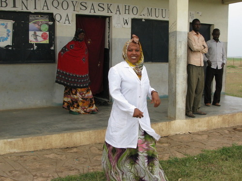
“A baby born today in Ethiopia is three times more likely to survive to age 5 than one born in 1990.  This progress isn’t a result of expensive international aid or the recruitment of foreign doctors into Ethiopia. Instead, the country has invested in simple, bare-bone clinics scattered around the country, which are run by minimally-educated community health workers.”

Seth Dixon‘s insight:

This NPR podcast shows how local programs that target rural health can have a massive impact on key demographic and development statistics.  This is great news– infant mortality rates around the world have dropped from 46 deaths/1000 to 35 deaths/1000 in the last 8 years and local programs such as this one have been a major reason why.   

Tags: Ethiopia, Africa, medical, development,

See on www.npr.org

The Future of Remote Sensing?

“We are pleased to introduce the world’s first high-resolution HD video of Earth taken from a commercial remote sensing satellite.

This video showcases a selection of the first videos taken from SkySat-1, the first of our planned 24 satellite constellation. The video clips have not yet been calibrated or tuned. SkySat-1 captures up to 90-second video clips at 30 frames per second. The resolution is high enough to resolve objects that impact the global economy like shipping containers, while maintaining a level of clarity that does not determine human activity.”

Seth Dixon‘s insight:

Most remote sensing videos show still images that are animated to give the temporal sequence a video-like quality.  Technology is changing rapidly and this video represents an impressive leap in our ability to monitor changes on Earth’s surface.  To read more about SkyBox Imaging and their plans, click here.   

Tags: remote sensing, geospatial, unit 1 GeoPrinciples.

See on www.youtube.com

Video of Remote Sensing

“We are pleased to introduce the world’s first high-resolution HD video of Earth taken from a commercial remote sensing satellite.

This video showcases a selection of the first videos taken from SkySat-1, the first of our planned 24 satellite constellation. The video clips have not yet been calibrated or tuned. SkySat-1 captures up to 90-second video clips at 30 frames per second. The resolution is high enough to resolve objects that impact the global economy like shipping containers, while maintaining a level of clarity that does not determine human activity.”

Seth Dixon‘s insight:

Most remote sensing videos show still images that are animated to give the temporal sequence a video-like quality.  Technology is changing rapidly and this video represents an impressive leap in our ability to monitor changes on Earth’s surface.  To read more about SkyBox Imaging and their plans, click here.   

Tags: remote sensing, geospatial, unit 1 GeoPrinciples.

See on www.youtube.com

9 questions about South Sudan you were too embarrassed to ask

“South Sudan’s crisis began just two weeks ago, on Dec. 15, and it already has observers warning that it could lead to civil war. Fighting has killed an estimated 1,000 people and sent 121,600 fleeing from their homes. International peacekeepers are preparing for the worst; some have been killed and a number of them, including four U.S. troops, have been injured.  What’s happening in South Sudan is complicated and can be difficult to follow; understanding how it got to be this way can be even tougher. Here, then, are the most basic answers to your most basic questions. First, a disclaimer: This is not an exhaustive or definitive account of South Sudan and its history — just some background, written so that anyone can understand it.”

See on www.washingtonpost.com

Best Posts of 2013

“A sampling of my 35 personal favorite posts of 2013. Enjoy!”

Seth Dixon‘s insight:

As we reflect on 2013 and prepare for 2014, I’ve compiled 35 post that were helpful to me in my classroom (see page 1 and page 2).  These are resources that I enjoyed curating or producing.  They might not be the best or the most important for your particular interests, but I look forward to continue curating this site and sharing valuable tidbits to geography educators in 2014.

See on www.scoop.it

Idaho’s the only state where a majority of adult households have no landlines

More adults in Idaho have embraced wireless life than have adults in any other state, according to new data from the Centers for Disease Control and Prevention.

Seth Dixon‘s insight:

Many associate wireless communications with the major metropolitan areas; this map and the data used to create it shows that rural states are more likely to abandon landlines. 

See on www.washingtonpost.com

Santas Around the World

This story map was created with the Esri Map Tour application in ArcGIS Online.

Seth Dixon‘s insight:

This story map shows some of the historical and regional differences in Santa Claus, as well as the cultural diffusion.  Merry Christmas to those that celebrate it and a Happy New Year to all. 

See on esripm.maps.arcgis.com

This Map Shows Why The Battle For ‘Ukraine’s Soul’ Is So Pivotal

The tug-of-war for Ukraine.

Seth Dixon‘s insight:

Strategically, Ukraine matters much more to Russia than it doesn’t the EU, which is why Russia is flexing there muscles.  Russia’s major market for their natural gas are linked through these key pipelines.  

See on www.businessinsider.com

Income inequality seen in satellite images from Google Earth

Nice visual on differences in income, with associated paper.  No stats needed here; a simple exploratory/observational curiosity is all you need.  A great starter for classroom discussions/lab activities. Start with this primer where you can see the distinct difference.

Seth Dixon‘s insight:

I certainly wouldn’t argue that trees create economic inequality, but there appears to be a strong correlation in between high income neighborhoods and large mature trees in cities throughout the world (see a scholarly reference from the Journal, Landscape and Urban Planning). Why is there such a connection? In terms of landscape analysis, what does this say about those who have created these environments? Why do societies value trees in cities? How does the presence of trees change the sense of place of a particular neighborhood? Click here for more Google images that show the correlation between income and trees.

See on flowingdata.com

Blog at WordPress.com.

Up ↑