Search

GEOGRAPHY EDUCATION

Supporting geography educators everywhere with current digital resources.

Author

sethdixon

I am a geography professor at Rhode Island College.

Guide to Earth Explorer for Landsat 8

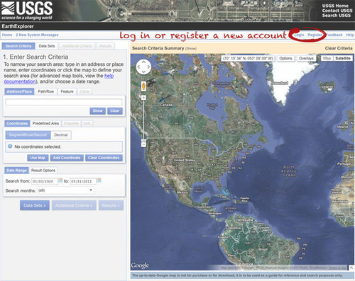
The Landsat Data Continuity Mission is now Landsat 8, and that means images are now public (woohoo!). NASA handed control of the satellite to the USGS earlier this year (May 30, 2013), and calibrated imagery is available through the Earth Explorer. Unfortunately, the Earth Explorer interface is a bit of a pain, so I’ve put together a guide to make it easier.

Seth Dixon‘s insight:

If you have been afraid to download remotely sensed images, this is a very-user friendly, step-by-step guide on how to download Landsat 8 data (and many other geospatial datasets)  using Earth Explorer from USGS.  

Tagsremote sensing, geospatial.

See on earthobservatory.nasa.gov

Create Your Own Map

MyMap

Create a color-coded Visited States Map, showing off your road travel in the United States and Canada.

Seth Dixon‘s insight:

This is map represents where I have been (green) and where I have lived (orange).  Super easy, anyone can use this site to create a small PNG file that maps out North America (maximum of 5 colors, including white).  For more on how to create your own, read here.

See on www.defocus.net

Modern Slavery

“I recently saw this map in a Washington Post article about modern day slavery and was immediately was struck by the spatial extent and amount of slaves in today’s global economy.  As stated in that article, “This is not some softened, by-modern-standards definition of slavery. These 30 million people are living as forced laborers, forced prostitutes, child soldiers, child brides in forced marriages and, in all ways that matter, as pieces of property, chattel in the servitude of absolute ownership.”  This map shows some important spatial patterns that seem to correlate to economic and cultural factors.”

Seth Dixon‘s insight:

This got me thinking to the geographies of supply chains.  The growing spread of the informal economy (a.k.a.-illicit trade, black market, etc.) has created opportunities for exploitation.  Many argue that free trade was created this power differential between the laborers who create these mass-manufactured products and the global consumers.  These critics argue that fair-trade, not free trade, with lead to sustainable economic growth and minimize social injustice. 

Questions to Ponder:  What economic and cultural forces are needed for slavery to thrive?  What realistically could be done to lessen the amount of slavery in the world today?  How are your spending habits part of the system?

This TED video (archived on scoop.it here) is a chilling glimpse into the worst and darkest side of the global labor system. 

Tags: labor, economic, class, poverty.

Geography of Quinoa

“The popularity of Quinoa has grown exponentially among the health-conscious food consumers in the developed economies of the world.  Quinoa (pronounced KEEN-wah) is rich in protein and is a better grain for those seeking to lose weight.  Quinoa has historically be rather limited but this diffusion is restructuring the geographic patterns of many places.” 

gitn_1195_NGS_Quinoa-2

Seth Dixon‘s insight:

This map from a Geography in the News article shows that Quinoa has historically been grown almost exclusively in the highlands of the Andes Mountains.  This was a localized food source for generations but this new global demand has increased the economic possibilities for Quinoa growers.  At the same time, local consumers that have traditionally depended on cheap Quinoa to supplement their diet are now effectively priced out, as stated in this Al-Jazeera article

Questions to Ponder: What modern and traditional agricultural patterns can we see in the production of Quinoa?  How have global and local forces reshaped the system?

Tags: agriculture, food production, foodglobalization, South America, folk cultures, culture, Bolivia.

See on geographyeducation.org

Geography of Quinoa

The popularity of Quinoa has grown exponentially among the health-conscious food consumers in the developed economies of the world.  Quinoa (pronounced KEEN-wah) is rich in protein and is a better grain for those seeking to lose weight.  Quinoa has historically be rather limited but this diffusion is restructuring the geographic patterns of many places.” 

Seth Dixon‘s insight:

This map from a Geography in the News article shows that Quinoa has historically been grown almost exclusively in the highlands of the Andes Mountains.  This was a localized food source for generations but this new global demand has increased the economic possibilities for Quinoa growers.  At the same time, local consumers that have traditionally depended on cheap Quinoa to supplement their diet are now effectively priced out, as stated in this Al-Jazeera article

Questions to Ponder: What modern and traditional agricultural patterns can we see in the production of Quinoa?  How have global and local forces reshaped the system?

Tags: agriculture, food production, foodglobalization, South America, folk cultures, culture, Bolivia.


See on geographyeducation.org

Geographically Yours

“If an urban population demands the freshest vegetables, they should be produced within a 24-hour field-to-table delivery zone.  What, therefore, should be the highest and best use of agricultural land between Taiwan’s two largest cities, Taipei and Kaoshiung, only 200 miles apart?  The Lord of the Rings, a.k.a., Johan Heinrich Von Thünen, has the answer.”  [2011]

Seth Dixon‘s insight:

This image and analysis comes from the blog “Geographically Yours” by Don Zeigler.  He’s a well-traveled cultural geographer and has been collecting great teaching images over his career and is now sharing them on this site.  These pictures are great discussion starters and bell ringers to start the day.

Tags: geo-inspiration, geography education, APHG, images.

See on geographicallyyours.blogspot.com

(Serbo-)Croatian: A Tale of Two Languages

“What language is spoken in Croatia? Croatian is now the 24th official language of the European Union, but there are disagreements about whether it’s a distinct language or just a slightly different dialect of Serbian. Serbian nationalists believe that everyone shares the same language, “Serbian”. But many Croats persist in making their national language as distinct from Serbian as possible. Listeners will discover how politics is intruding on language, and how it is changing the map of linguistic patterns in unexpected ways.

Tags: language, Croatiapolitical, podcast, Maps 101.

See on maps101blog.com

17th century London visualized

“Six students from De Montfort University have created a stellar 3D representation of 17th century London, as it existed before The Great Fire of 1666. The three-minute video provides a realistic animation of Tudor London, and particularly a section called Pudding Lane where the fire started. As Londonist notes, “Although most of the buildings are conjectural, the students used a realistic street pattern [taken from historical maps] and even included the hanging signs of genuine inns and businesses” mentioned in diaries from the period.

Seth Dixon‘s insight:

This video original spotted in an Open Culture article is a real gem for any historical geographer with a love for London.

Tags:  virtual tours, EnglishLondon, urban, historical, visualization.

See on www.youtube.com

Rising Seas: If All The Ice Melted

Explore the world’s new coastlines if sea level rises 216 feet.

Seth Dixon‘s insight:

If all the ice in the world melted, we wouldn’t have a post-apocalytic scenario like Kevin Costner’s “waterworld,” but  it still would have an enormous global impact.  This interactive feature highlights the locations of places that would be submerged in the most extreme example of hypothetical sea level changes.  What would some of these changes be?  

See on ngm.nationalgeographic.com

Create a free website or blog at WordPress.com.

Up ↑