Search

GEOGRAPHY EDUCATION

Supporting geography educators everywhere with current digital resources.

Author

sethdixon

I am a geography professor at Rhode Island College.

Indian Independence and the Question of Partition

The partition of 1947, which led to the creation of India and Pakistan, was one of the most volatile events of the twentieth century. Partition coincided with the end of British colonial rule over the subcontinent, and Indian independence was overshadowed by violence, mass displacement, and uncertainty.

The scholars in this video were interviewed for the Choices Program curriculum, “Indian Independence and the Question of Partition”. For more information, visit the Choices Program.

See on vimeo.com

Typhoon Haiyan Before & After

View interactive before and after images showing the devastation Typhoon Haiyan has caused in Tacloban City, Philippines.

Seth Dixon‘s insight:

While the casualty counts may have been lowered, that does not lessen the devastation. 

See on www.abc.net.au

How Online Mapmakers Are Helping the Red Cross Save Lives in the Philippines

Volunteers across the world are building the digital infrastructure for the organization’s Typhoon Haiyan relief efforts

Seth Dixon‘s insight:

Crowd-sourced mapping is increasingly an important resource during an emergency.  Poorer places are often not as well mapped out by the commercial cartographic organizations and these are oftentimes the places that are hardest hit by natural disasters.  Relief agencies depend on mapping platforms to handle the logistics of administering aid and assessing the extent of the damage.  Can you join in and help?

Tags: disasters, mappingPhilippines.

See on www.theatlantic.com

Philippines

Ruling On NYC Disaster Plans For Disabled May Have Far Reach

“A year after Superstorm Sandy stranded many New Yorkers without power for days, a federal judge has ruled that New York City’s emergency plans violate the Americans with Disabilities Act. Those shortcomings, the judge found, leave almost 900,000 residents in danger, and many say the ruling could have implications for local governments across the country.”

Seth Dixon‘s insight:

I have many more questions than answers after listening to this podcast.  Presumably, most governmental agencies during emergencies are seeking to assist the greatest number of people with limited time and resources; would this court ruling change that mandate?  How will this impact urban planning in the future?  Just how much can plans in times of emergency account for assisting the disabled?  Do you think the City of New York was negligent? 

Tags: disasters, NYC, transportationurban, planning, podcast.

See on www.npr.org

‘Absolute Bedlam’ In The Philippines After Typhoon Haiyan

The news from the Philippines, where it’s feared that last week’s powerful Typhoon Haiyan killed more than 10,000 people, isn’t getting better as hundreds of thousands of people struggle to survive and authorities struggle to get help to them.

“Its absolute bedlam right now,” says Richard Gordon, head of the Philippine Red Cross.  “There’s an awful lot of casualties, a lot of people dead all over the place, a lot of destruction.”

According to the BBC, a huge international relief effort is underway, but rescue workers have struggled to reach some towns and villages cut off since the storm.

Tags: physical, environment, water, disasters, Philippines.

See on www.npr.org

National cemeteries create a ‘sacred grove’ of equality

In the end, rank falls away

Seth Dixon‘s insight:

This Veteran’s day many will go to cemeteries to remember fallen soldiers.  These are secular sites, but still sacred space to many.  The sanctity of these places are intentional and considerable planning goes into the spatial layout and design of the cemeteries.  Enjoy the day off for Veteran’s Day, but don’t forget to remember.

See on www.startribune.com

Why is Geography Education so Important?

Seth Dixon‘s insight:

This commencement speech from the President of the American Geographical Society highlights the importance of geographic thought and geo-literacy for college graduates.  I share this because (to quote Summer Howarth), “geo-literacy isn’t really optional.” 

See on www.amergeog.org

The 11 American nations, in one map

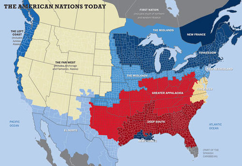
Red states and blue states? Flyover country and the coasts? How simplistic. Colin Woodard, a reporter at the Portland Press Herald and author of several books, says North America can be broken neatly into 11 separate nation-states, where dominant cultures explain our voting behaviors and attitudes toward everything from social issues to the role of government.

“The borders of my eleven American nations are reflected in many different types of maps — including maps showing the distribution of linguistic dialects, the spread of cultural artifacts, the prevalence of different religious denominations, and the county-by-county breakdown of voting in virtually every hotly contested presidential race in our history,” Woodard writes in the Fall 2013 issue of Tufts University’s alumni magazine. “Our continent’s famed mobility has been reinforcing, not dissolving, regional differences, as people increasingly sort themselves into like-minded communities.”

Take a look at his map.

See on www.washingtonpost.com

Geography Poster

See on rigea.files.wordpress.com

Create a free website or blog at WordPress.com.

Up ↑