Seth Dixon‘s insight:
The PRB World Population Data Sheet is a great resource; now you can access that same data through this interactive map.
See on www.prb.org
The PRB World Population Data Sheet is a great resource; now you can access that same data through this interactive map.
See on www.prb.org
A geographer and a biologist at Salem State University team up to curate a new exhibition, featuring confounding views from both satellites and microscopes
When I teach why scale is an important concept in geography, I say that depending on the situation a scientist might need a microscope or a telescope to properly understand a phenomenon. Most images give us enough context clues to help us determine the scale of the image, but this set of 15 images does not. So is it micro or macro?
Tags: space, scale, perspective.
See on blogs.smithsonianmag.com
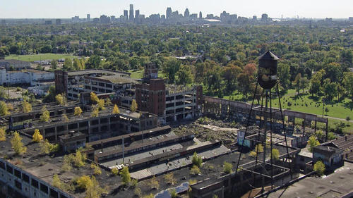
Bob Simon reports on the decline of America’s former industrial capital and the people determined to bring it back
Detroit is the largest city to declare bankruptcy and more importantly the first major American city to essentially fail as a major metropolitan area. Sections of the city are reminiscent of a post-apocalyptic bestselling novel: 80,000 buildings stand empty, 40% of the streetlights don’t work, and it routinely takes police one hour to respond to a 911 call.
See on www.cbsnews.com
With rapid urbanization under way, cities want to call their own shots. Increasingly, they can.
This article could just as easily been titled, “The rise of the modern city-state.” Parag Khanna (known for his TED talk, Mapping the Future of Countries) argues in this article that governance is happening increasingly at the city scale. “In the face of rapid urbanization, every city, state or province wants to call its own shots. And they can, as nations depend on their largest cities more than the reverse.”
Questions to Ponder: Is this devolution? How so? How does this make us rethink political power and ‘the state?’ How might this shift reshape the world? How might this concept relate to the the term primate cities?
See on www.nytimes.com
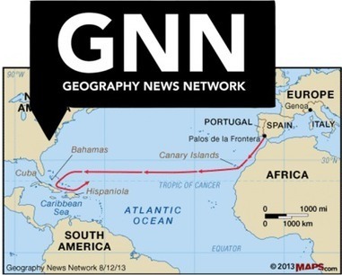
“This Geography News Network Article podcast is an historical description of Christopher Columbus’s role in discovering the Americas.”
See on maps101blog.com

“This is a ship-shipping ship, shipping shipping ships.”
The two industries that are the real backbone of globalization are transportation and technology. What has accelerated the pace of global interconnectedness is the scale of these devices and their ubiquity in facilitating massive global commerce. Economies of scale infuse our transportation and communicating technologies, boosting the diffusion of countless other technologies. China’s transportation infrastructure, for example has undergone some amazing physical transformations that have made their economic growth possible.


Tags: transportation, globalization, diffusion, industry, economic.
If however you only want to laugh at the tongue-twister of ship-shipping ships, this is the internet meme for you.

From grains to grapes to cabbage and many other crops the harvest season has been in full swing in the Northern Hemisphere.
So few of my students have actual experience working on a farm and being part of the food producing process. This gallery of 38 photos around the world is a great visual to reinforce how important the harvest is for sustaining life on this planet. The picture above shows the a Hmong hill tribe woman harvesting a rice terrace field at Mu Cang Chai district, northern Vietnamese province of Yen Bai. The World Bank on Oct. 7 lowered its 2013 growth forecast for East Asian developing countries to 7.1 percent and warned that a prolonged US fiscal crisis could be damaging to the region.
Tags: agriculture, food production, landscape, images.
See on www.boston.com
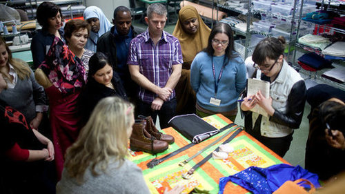
Factories are finding that years of doing business overseas has withered what once was a thriving textile and apparel work force in the United States.
Historically, waves of immigrants came to the United States to work in textile mills. Since 1990, 77% of manufacturing jobs have been outsourced to places with lower wages as the industry has become automated. Today though, specialty items that still need to done by hand are coming back to the U.S. and wages in that sector are rising as American consumers want a “made in the USA” label.
Tags: manufacturing, North America, labor, USA.
See on www.nytimes.com
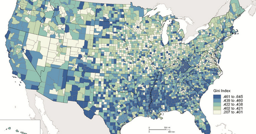
Think everyone should just pull themselves up by their bootstraps? Try this one on for size.
This video shows the place matters; a Washington D.C. educator shows how food deserts and other spatial problems of poverty impact his students on a daily basis.
We usually look at life expectancy data at the national scale and that obscures some of the real issues of poverty in developed countries. Above is a map that shows the Gini index which measures the degree of economic inequality (the Gini coefficient was recently added to the APHG course content for the Industrialization and Economic Development unit). Here are some maps and data from the World Bank that utilizes the Gini Index as well as an interactive Gapminder graph.
Tags: industry, location, place, migration, APHG, poverty, socioeconomic.
See on www.upworthy.com