Search

GEOGRAPHY EDUCATION

Supporting geography educators everywhere with current digital resources.

Author

sethdixon

I am a geography professor at Rhode Island College.

Bad TV Maps

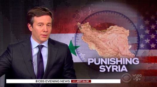
“If you have been on social media this week, you have seen screenshots of this week’s CBS News broadcast on Syria, which in fact displayed a map of Iran. Many jokes were made, many tweets went viral. As connoisseurs of hilariously wrong TV news maps, this is nothing. Kids’ stuff. We have dug deep into our collection, gathered lovingly over the years, and now invite you to follow along on a tour of the world according to TV news.”

Source: static.nytimes.com

News organizations are in the business of prioritizing speed and accuracy, but sometimes those priorities come into conflict.  These are but a few of many examples of poor cartography in media.  While this isn’t all there is to geographic illiteracy, this is certainly one of the most obvious to the general public. If only there were the only element of geographic illiteracy in media coverage. 


Tagscartography, media

Italy’s Geographic Challenge

“Stratfor explains that Italy’s main geographic challenge is to preserve its unity despite strong regional identities.”  For more of these videos, visit http://arcg.is/1IeK3dT

Source: www.youtube.com

Italy’s a country that we may think of as monolithic, but (like so many other countries) it has some deep and persistent regional distinctions.  These videos are older, but the the divisions discussed are still pertinent.  Stratfor also added a video of Italy in their “Geographic Challenge” series.  I’ve updated my map which spatially indexes 70+ of their videos that are especially relevant to geography teachers to include this one.  These videos are great starting points for students that are researching a particular country.


Tagsvideogeography education, ItalyEurope, regions.

What Anthony Bourdain Understood About Cities

The work of the acclaimed chef and writer, who has died at 61, provides a model for a truly inclusive urbanism based on the creativity of all human beings.

Source: www.citylab.com

At the APHG reading last week, it felt as if everyone was in shock and mourning Anthony Bourdain’s passing.  I felt so amazingly thick, but I was dying to ask "who?"  Judging by everyone’s reaction, I think I’m the only geographer who has never watched any of his shows and was feeling the shame.  I quickly checked out Parts Unknown (on Netflix) and the appeal of his work was immediately evident; it is more about place than it is strictly about the food.  Food is simply his portal into understanding the people, culture, and politics of a given place.  Some say that his approach brings an anti-colonial flair to urbanism and travel, but as I’m a newbie to his work, I’m just going to start appreciating it now as we mourn his loss.


Tags: cultureworldwide, diffusion, urban, urbanism, place, food,

 colonialismvideo, media


At Seattle Mariners games, grasshoppers are a favorite snack

“Chapulines [grasshoppers] have become a snack favorite among baseball fans in Seattle. Follow their path from Oaxaca, Mexico, to Safeco Field. To many, the insect might be a novelty – a quirky highlight for an Instagram story from a day at the ballpark. To those in Mexico consuming them for centuries, they are a building block of nutrition.”

Source: www.espn.com

Eating insects is incredibly nutritious; raising them is cost effective and environmentally sustainable. And yet, the cultural taboos against entomophagy in the West are barriers to the cultural diffusion of the practice.  At some baseball games and high-end restaurants, grasshoppers are sold as a novelty item.  What I especially enjoy about this ESPN article is that it covers the cultural production of the chapulines in Mexico and follows the story to the consumption of the grasshoppers in the United States.  


Tags: sport, popular culturediffusion, culturecultural norms, foodMexico, economic, agriculture.

2018 APHG Reading Professional Development

"This has been my first year as Chief Reader of the AP Human Geography reading and it is amazing to watch all the moving parts come together.  It couldn’t happen without such dedicated, professional, and passionate geography educators all working together.  I was delighted to have Dr. Marie Price, President of the American Geographical Society, be our professional development night speaker and she was outstanding.  Her talk, MIGRATION AS A CROSSCUTTING THEME IN HUMAN GEOGRAPHY,  proved that her geographic expertise is only matched by her teaching prowess; the audience was riveted (PDF of slides here)."

Source: geographyeducation.org

NIGHT OF THE ROUND TABLES: Thursday evening, June 7th we had our annual “Night of the Round Tables” event. This event was designed to create a place to share new ideas, pick up lesson plans, discover new resources, and develop strategies for teaching geography. Presenters had 15 minutes to present. Here you can find the digital copies of the presentations given. 

Tags: APHG, teacher training, geography education.

Why does the misperception that slavery only happened in the southern United States exist?

//cdn.embedly.com/widgets/media.html?src=https%3A%2F%2Fplayer.vimeo.com%2Fvideo%2F217064279&dntp=1&wmode=opaque&src_secure=1&url=https%3A%2F%2Fvimeo.com%2F217064279&image=https%3A%2F%2Fi.vimeocdn.com%2Fvideo%2F636139782_1280.jpg&key=25394e42b38f11e0ae3f4040d3dc5c07&type=text%2Fhtml&schema=vimeo

“Christy Clark-Pujara research focuses on the experiences of black people in British and French North America in the seventeenth, eighteenth and early nineteenth centuries. She examines how the business of slavery—the buying and selling of people, food, and goods—shaped the experience of slavery, the process of emancipation, and the realities of black freedom in Rhode Island from the colonial period through the American Civil War.”

Source: vimeo.com

This is one of the many videos produced by the Choices Program about slavery in the New England (especially Rhode Island).  Featured in the videos is Dr. Christy Clark-Pujara, who wrote “Dark Work: The Business of Slavery in Rhode Island.”  There is a reason to what we learn in history, and there are also reasons to the histories that are rarely told.  More than any other of the original thirteen colonies and states along the Eastern Seaboard, Rhode Island plied the triangle trade transporting more slaves to the Americas than all the other states combined.


Some Rhode Island slavery facts:

  • In 1776, Rhode Island had the largest proportion of slave population of any of the New England colonies.
  • During the antebellum period Rhode Islanders were the leading producers of “negro cloth,” a coarse wool-cotton material made especially for enslaved blacks in the American South.
  • More than 60 percent of all the slave ships that left North America left from Rhode Island.


Tags: raceRhode Island, slavery, labor, economic, historical.

Map: Where Are Confederate-Named Schools?

Most schools with names tied to the Confederacy are in the South, were built or named after 1950, and have a student body that is majority non-white.

Source: www.edweek.org

The maps (and the charts) created from this national database is quite revealing.  At least 36 ‘Confederate-themed’ schools have changed their names since 2015 and I suspect that number will continue to grow in the coming years.    


Tags: race, racism, landscape, historicalthe South.

Five ways China’s past has shaped its present

“The country is perhaps more aware of its own history than any other major society on earth. That remembering is certainly partial – events like Mao’s Cultural Revolution are still very difficult to discuss within China itself. But it is striking how many echoes of the past can be found in its present.”

Source: www.bbc.com

This is a very interesting article…one can make too much of a country’s history as a casual factors, and yet make too little of historical patterns at your own peril.  “To understand China’s approach today to trade, foreign policy or censorship, consider its history.”  This article considers a few of  China’s current policies that may seem peculiar today but that make much more sense with a longer and deeper history.  Some of the topics considered include:

  • trade
  • trouble with neighbors
  • Information flow
  • Religious freedoms
  • Technology


Tags: China, East Asia, historical.

The World’s Most Economically Powerful Cities

“The newest ranking of the world’s most economically powerful cities put together by Martin Prosperity Institute (MPI) research team finds New York to be the clear winner [over London]. Our Global City Economic Power Index  is based on five core metrics: Overall Economic Clout, Financial Power, Global Competitiveness,

Equity and Quality of Life.” 

Source: www.citylab.com

100 years ago, the biggest trends in urbanization showed that the biggest cities in the world were also the most economically powerful cities in the world in core areas.  In the last 50 years, the most obvious change has been the remarkable growth in of the world’s largest cities in the developing world.   

Questions to Ponder: Why has there been such spectacular growth of megacities, especially in the developing world?  How is this map ranking global cities different from a list of the world’s largest cities?  What regional patterns do exist in the 25 most economically powerful cities in the world?  What are the implications of these patterns?    


Tags: urban, megacities, regions.

Create a free website or blog at WordPress.com.

Up ↑