For centuries, civilization has focused on using maps as a form of communication. To lead you down a rabbit hole, I was curious on famous cartographers, and in…
See on www.govloop.com
For centuries, civilization has focused on using maps as a form of communication. To lead you down a rabbit hole, I was curious on famous cartographers, and in…
See on www.govloop.com
“This case study examines the challenges of human well-being and urbanization, especially in the megacity of Jakarta.”
Megacities are growing, especially in the developing world. This rapid population growth leads to serious strains on many resources and the infrastructural capacities which leads to some dismal living conditions among the urban poor. World Vision Australia works to assist and empower many of those without access to these important amenities. Download the lesson as a PDF here.
Tags: Indonesia, urban, megacities, sustainability, development.
See on www.youtube.com
“Technology is reshaping our economic geography, but there’s disagreement as to how. Much of the media and pundits like Richard Florida assert that the tech revolution is bound to be centralized in the dense, often ‘hip’ places where ‘smart’ people cluster.
From 2001 to 2012, STEM employment actually was essentially flat in the San Francisco and Boston regions and declined 12.6% in San Jose. The country’s three largest mega regions — Chicago, New York and Los Angeles — all lost tech jobs over the past decade. In contrast, double-digit rate expansions of tech employment have occurred in lower-density metro areas such as Austin, Texas; Raleigh, N.C.; Columbus, Ohio; Houston and Salt Lake City. Indeed, among the larger established tech regions, the only real winners have been Seattle, with its diversified and heavily suburbanized economy, and greater Washington, D.C., the parasitical beneficiary of an ever-expanding federal power, where the number of STEM jobs grew 21% from 2001 to 2012, better than any other of the 51 largest U.S. metropolitan statistical areas over that period.” Read more.
See on www.newgeography.com
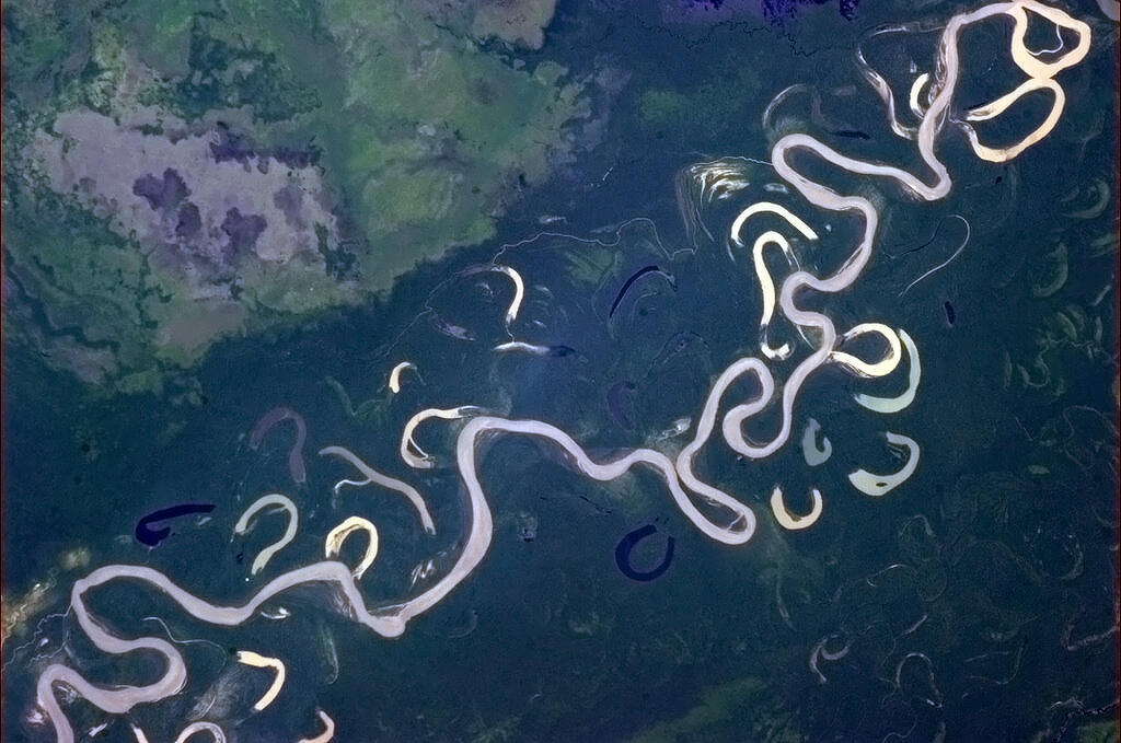
“I’m used to rivers that know what they’re doing.”
This incredible image clearly demonstrates the fluvial processes that have creating and this and will continue to reshape this landscape. Meander scars, oxbow lakes, channel cutoffs, floodplains and point bars are all here in this gorgeous teaching image.
Tags: physical, fluvial,geomorphology, erosion, landscape.
Even though Chris Hadfield’s time on the space station is over, his twitter stream can still be a great source of images displaying the physical and human landscapes (and if you needed any more evidence that he’s the coolest astronaut ever, watch his parting video singing David Bowie’s Space Oddity).
See on twitter.com

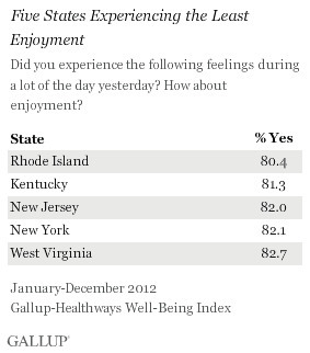
“For the past five years, Hawaii has consistently ranked as the least stressed state, while West Virginia, Kentucky, and Utah have been among the most stressed states. Despite this, Utah residents join Hawaii residents in reporting among the highest levels of enjoyment in the U.S., while West Virginia and Kentucky residents report some of the lowest levels of enjoyment. While the relationship between stress and enjoyment is not clear, states with the highest stress levels tend to report less daily enjoyment.”
In addition to being the state with the least joy, Rhode Island is ranked as the 2nd most stressed out state. I think that means it’s time to to get out of the Ocean State for a while.
Questions to Ponder: what are some factors that may account for this regional variation? What explains your states relative levels of stress and enjoyment?
See on www.gallup.com
Transportation planner plots pattern of airline travel across the globe.
This set of 9 images displays 58,000 flight paths from various perspectives. What patterns do you see emerging from as you are able to visualize this data? What does this tell you about the world today?
Tags: visualization, transportation, statistics, globalization, mapping.
See on www.bbc.co.uk
The Daily Rundown’s Chuck Todd takes a look at the National Geographic Bee and talks with host of the bee and of Jeopardy, Alex Trebek. Trebeck tells Todd that Americans are woefully ignorant when it comes to geography.
I know some people who aren’t huge fans of the geography bee because they feel that the format reinforces the stereotype that geography is about memorizing encyclopedic facts about places (I support the Bee in part because of the tremendous visibility it give for geography on a yearly basis). While many of the questions do follow that format, that is primarily because it is structured for the elementary and middle school grades. In high school and college, geography education draws on that ‘fact-based’ knowledge set about places and fosters spatial thinking skills which our labor force lack. This video reminds of the current state of affairs, but I’m glad to see this conversation being had in the media.
See on video.msnbc.msn.com
The GA supports primary and secondary geography teachers through teaching resources, geography journals, CPD events, Barnaby Bear, Worldwise and more.
The Geographical Association (American reader can think of the GA as the UK version of the NCGE) is preparing for the end of the school year by preparing resources for geography teachers.
See on geography.org.uk
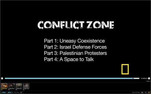
“In a new series of four eight-minute videos, National Geographic Emerging Explorer Aziz Abu Sarah is a cultural educator working to build relationships between Israelis and Palestinians in Jerusalem and throughout Israel. In this series of four eight-minute videos, Abu Sarah meets with people from both sides of the conflict in order to better understand and communicate how this international dispute impacts their everyday lives.”
Tags: Israel, borders, Palestine, territoriality, political, Middle East.