Search

GEOGRAPHY EDUCATION

Supporting geography educators everywhere with current digital resources.

Author

sethdixon

I am a geography professor at Rhode Island College.

Guerrilla Cartographers Put Global Food Stats On The Map

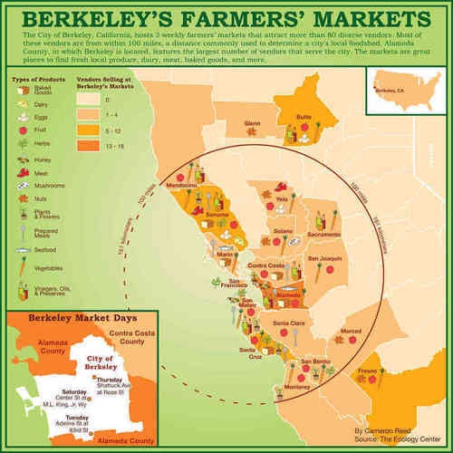
The mapmakers have amassed some 80 maps for Food: An Atlas, ranging from surplus in Northeast Italy to meat production in Maryland. The goal is to spread information about various food systems so they can be adapted locally.

Social media is enhancing digital cooperation to enable some intriguing grass-roots projects such as this one. 

Tags: food, agriculture, mapping.

See on www.npr.org

Chinese passport map causes diplomatic dispute

Experts warn that China’s apparent claims to other territories could have a long-term impact on relations with its neighbours…

Many people assume oftentimes that a map merely reflects reality.  In this passport map, China is flexing it’s regional muscles, trying to reinforce their territorial claims as legitimate.  Not surprisingly, their neighbors with competing claims are angered, calling this map dimplomatically “unacceptable.”  Some look at this map and dismiss it as a glorified watermark.  What you you think the sub-text this maps is?  You can find another article on this topic in the Washington Post

Tags: cartography, China, borders

See on www.guardian.co.uk

The Geography of a Pencil

A film from the Competitive Enterprise Institute, adapted from the 1958 essay by Leonard E. Read.

This year’s Geography Awareness Week’s theme was “Declare Your Interdependence!”  The GAW poster for 2012 focused on the Geography of a Pencil and this video works together nicely as a supplement to that poster.  You may see the economics of capitalism and globalization in a less optimistic light than Leonard Read, but the theme of interconnectedness makes this a great resource.

See on www.youtube.com

Elderly Spur Japan Stores

Unicharm Corp.’s sales of adult diapers in Japan exceeded those for babies for the first time last year. At Daiei Inc. supermarkets, customers can feel Japan aging — literally: It has made shopping carts lighter.

Japan’s demographic shifts are well-chronicled: the Japanese are having fewer children and the improvements in healthcare mean that the elderly are living longer than ever.  Combined this means that Japan’s population pyramid is getting “top heavy.”  This population change is having huge econmic impacts as the percentage of Japanese people is now over 23%.  Retailers and industries are heavily targeting this expanding demographic with financial clout that outspends all other cohorts.

Tags: Japan, declining population, economic, population, demographics, unit 2 population, East Asia, consumption.

See on www.bloomberg.com

Will Puerto Rico Be America’s 51st State?

Millions of American citizens on the island have spoken. Now, Washington must act.

After the Nov. 6th referendum, the question of Puerto Rico’s political status vis-a-vis the United States for the future is actually murkier than it was before.  The Puerto Rican voters have spoken, but the meanings of the plebiscite results are still being debated.

See on www.nytimes.com

Ed Fairburn’s Deutschland

I have a weak spot for art that uses cartography as both the medium and canvas.  This links you to the artist’s site, but you may also wish to see this article with a nice gallery of his cartographically inspired art.

Tags: art, geo-inspiration.

See on edfairburn.com

Chinese-Mexicans Celebrate Return To Mexico

MEXICO CITY — Juan Chiu Trujillo was 5 years old when he left his native Mexico for a visit to his father’s hometown in southern China. He was 35 when he returned.

Migratory patterns and globalization can lead to some intriguing cultural blends that would seem improbable 100 years ago.  This story of shows vividly how ethnicity does NOT always correspond to culture.

See on www.huffingtonpost.com

What Could Disappear?

Coastal and low-lying areas that would be permanently flooded in three levels of higher seas.

This interactive feature is designed to answer a simple, yet profound set of questions.  What areas (in over 20 cities around the U.S.) would be under water if the ocean levels rose 5 feet?  12 feet?  25 feet?  The following set of maps show “coastal and low-lying areas that would be permanently flooded without engineered protection.”

See on www.nytimes.com

Designs to Fit More People in Every City

TED Talks How can we fit more people into cities without overcrowding? Kent Larson shows off folding cars, quick-change apartments and other innovations that could make the city of the future work a lot like a small village of the past.

This talk is relevant not just because it focuses on many urban issues; it also is a fantastic demonstration of how to use spatial thinking to solve problems.

Tagsdensity, urban, spatial, planning, TED.

See on www.ted.com

Create a free website or blog at WordPress.com.

Up ↑