Search

GEOGRAPHY EDUCATION

Supporting geography educators everywhere with current digital resources.

Author

sethdixon

I am a geography professor at Rhode Island College.

Top 10 Ways to Go Green this Holiday Season

10 ways to go green this holiday season. Zero Waste holiday tips from Eco-Cycle.

This infographic combined with these recommendations are some simple reminders that mass consumption and waste does not comtribute to global joy or cheer. 

See on ecocycle.org

Keeping up with ‘Geography Education’

Finding Materials: This site is designed for geography students and teachers to finding interesting, current supplemental materials.  To search for place-specific posts, browse this interactive map.  To search for thematic posts (organized by the APHG curriculum) see GeographyEducation.org  Also you can search for a keyword by clicking on the filter tab.

Staying Connected: You can receive post updates in the way that best fits how you use social media.

Update Notifications: Twitter, Facebook, Pinterest.

Email: Click ‘follow’ button at top right of this page.

Sites with Content: WordPress, Scoop.it.

See on www.arcgis.com

More than a club: FC Barcelona and Catalonia’s road to independence

As Catalonia goes to the polls, Sid Lowe looks at one of the region’s great cultural sporting icons and its role in Catalan identity…

Sports and cultural identity of a region are often intertwined. As Catalonia is poised to break from Spain, this video shows how the local teams (especially FC Barcelona) are at the center of political identity and part of the very fabric of the political movement that is pushing for independence.

Tags: sport, Spain, Europe, devolution, autonomy.

See on www.guardian.co.uk

Kids Placemaps

Using addresses you input and your choice of icons, we add your child’s favorite places to a custom neighborhood map that includes real cartographic features, such as street names and north arrow.

What happens when a city planner becomes a parent?  Kids Placemaps!  Combining cartographic expertise and a desire to start geography education at a very early age, the founders of Kids Placemaps have personalized a child’s geography in a tangible, simple fashion.  

See on www.kidsplacemaps.com

Modern Atlantis: Sandy Island shown in marine charts, Google Maps and Earth, doesn’t actually exist

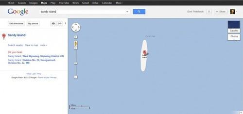
There’s a South Pacific island positioned midway between Australia and New Caledonia featured on various marine charts, world maps, and has appeared in publications since at least the year 2000. It’s listed as Sandy Island on Google Maps and Google Earth, and yet Australian scientists have just discovered it doesn’t exist.

As part of a 25-day voyage, the group went to the area, only to find 1,400m (4,620ft) of the Coral Sea. The team collected 197 different rock samples, more than 6800km of marine geophysical data, and mapped over 14,000 square kilometres of the ocean floor.

See on thenextweb.com

Sahel food crisis

The hunger crisis in the Sahel region of Senegal, Mauritania, Mali, Burkina Faso, Niger and Chad has been deepening since the start of this year.

The Sahel is a classic transition zone–a border that is not a sharp division, but a gradual shift from one region to the next.  This area has environmentally marginal lands, but is as population pressures continue, marginal lands need to sustain more people. 

See on www.guardian.co.uk

Israeli/Palestine Conflict

My lecture 2 weeks ago is now hopelessly outdated; thankfully my Rhode Island College students collaborated with me to put together resources that are helpful for understanding the geopolitical issues in the Middle East today.

With a simple class hastag (e.g.-#geog400ric) you can create a backchannel for student to collaborate outside the classroom walls. 

See on storify.com

Global cities of the future

Explore the cities and emerging urban clusters that will drive dramatic growth and demographic changes over the next generation. A McKinsey Quarterly Economic Studies article.

In the next 13 years, 600 cities will account for nearly 65 percent of global GDP growth. That is reason enough to explore this global dataset with over 2,600 metropolitan areas. 

See on www.mckinseyquarterly.com

Timelapse of Route 66

USA Route 66 Cross Country Road Trip Map, Data, Summary, Photos, Equipment Used: http://www.defreesproductions.com/road-trip-route-66-cross-country-usa-2012

I saw this video on an Atlantic Cities article and was struck by the rural and “off-the-beaten path” feel that timelapse of the Mother Road manages to capture.  Route 66 looms large in Americana, in part because it represents a bygone era, a time when the automobile was new and exciting. This empowered many to make a cross-country road trip, but during this time the car was not so ubiquitous that it was the overwhelming force that is so visually prominent in urban landscapes as it is today.  The historical and cultural critique of the U.S. automobile culture in the Pixar movie Cars may be fictional and for a child audience, but it is quite accurate in noting that cities disconnected from the interstate system sharply declined and were never the same.  These places represent for many people then, a classic pop culture landscape of yesteryear.

Tags: transportation, landscape, place, culture, timelapse.

See on www.youtube.com

Create a free website or blog at WordPress.com.

Up ↑