Search

GEOGRAPHY EDUCATION

Supporting geography educators everywhere with current digital resources.

Author

sethdixon

I am a geography professor at Rhode Island College.

What Would Happen If The Entire World Lived Like Americans?

After making an infographic depicting how much space would be needed to house the entire world’s population based on the densities of various global cities, Tim De Chant of Per Square Mile got to thinking about the land resources it takes to support those same cities.


Tags: consumption, development, resources, energy, density, sustainability.

See on www.fastcoexist.com

Ephemicropolis

If you have over 100,000 staples, you can create an startlingly creative rendition of an urban landscape (well, Peter Root could).   It is interesting how our cultural and historical context shape what we see as a human landscape.  I can’t help but think that if I lived 2,000 years ago this uneven jumbled metallic mass wouldn’t remind anyone of any place they’d ever been.

Tags: art, urban, landscape, unit 7 cities, historical.

See on www.peterroot.com

Image Analysis

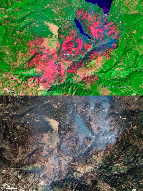
One of a number of large wildfires that have affected northern California in 2012, the Chips fire burned more than 75,000 acres by the time firefighters had contained it.

2012 is going to go down in United States history as the year with the most acres burned in a single year (statistics only go back to 1960).  The two featured images were taken earlier this month to display a Northern California wildfire; both with the same spatial resolution and acquired for the same instrument (Advanced Land Imager on EO-1 satellite), yet they are quite distinct.  One shows an aerial photograph, displaying exactly what standard visible portion of the electromagnetic spectrum (showing us what our eyes would normally see).  The other image displays a false color (near infrared) image.

Questions to ponder: what advantages does each image have for analyzing the fire damage?  Drawbacks?  How does the data from both images work together to create a more complete picture of the situation?

Tags: remote sensing, images, environment, land use, disasters, biogeography.

See on earthobservatory.nasa.gov

Disputed Isles

Competing territorial claims have led to maritime disputes off the coast of Asia. See a map of the islands at issue.

This is an nice interactive map that allows the reader to explore current geopolitical conflicts that are about controlling islands.  This is an good source to use when introducing Exclusive Economic Zones, which is often the key strategic importance of small, lightly populated islands.

Tags: EastAsia, SouthEastAsia, political, unit 4 political, territoriality, autonomy, conflict, economic.

See on online.wsj.com

An Annotated Map of Today’s Protests and of the ‘Muslim World’

The violent backlash against the American film is taking place in Muslim societies, but it doesn’t seem to correlate with Islam’s reach.

This is a good reminder that the generalizing about “all Muslims” is as inaccurate as generalization about “all Christians” or any other group.  The world and people are much more nuanced than that. 

Tags: MiddleEast, Islam, conflict.

See on www.theatlantic.com

How The USA Expanded In One Mesmerizing Animated GIF

Amazing work from wikipedia, summarizing the evolution of the US formation, originally here: http://en.wikipedia.org/wiki/Territorial_evolution_of_the_United_States

Tags: USA, historical, visualization

See on edudemic.com

The Authoritative Map

In the Winnie the Pooh Movie “Pooh’s Grand Adventure,” the character Rabbit has absolute confidence in the printed word and especially the map.

Questions to ponder:  How much do we trust any given map?  How much should we trust a map (or the printed word)?  What makes a document reliable or unreliable?

Tags: mapping, perspective, K12, video.

See on www.youtube.com

On Israel’s system of segregated roads in the occupied Palestinian territories | Visualizing Palestine

Tags: MiddleEast, territoriality, transportation, borders, conflict, governance, political, unit 4 political

See on visualizingpalestine.org

The Lower Ninth Ward in New Orleans Gives New Meaning to ‘Urban Growth’

Since Katrina, the cartoonish pace of vegetation growth in the Lower Ninth Ward of New Orleans resembles something out of a Chia Pet commercial.

The ecosystem is reclaiming parts of New Orleans that have been physically or economically abandoned.  This is part elevation, climate and ecosystem; but it is also about urban land uses, disinvestment and socioeconomics.

Tags: urban ecology, environment, ecology, urban, unit 7 cities, disasters.

See on www.nytimes.com

Create a free website or blog at WordPress.com.

Up ↑