Search

GEOGRAPHY EDUCATION

Supporting geography educators everywhere with current digital resources.

Category

Uncategorized

Best Posts of 2013

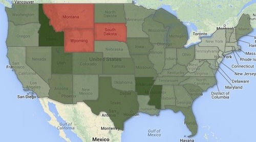
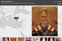
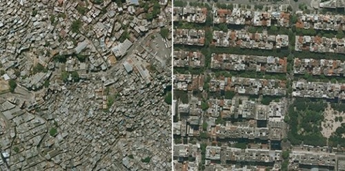
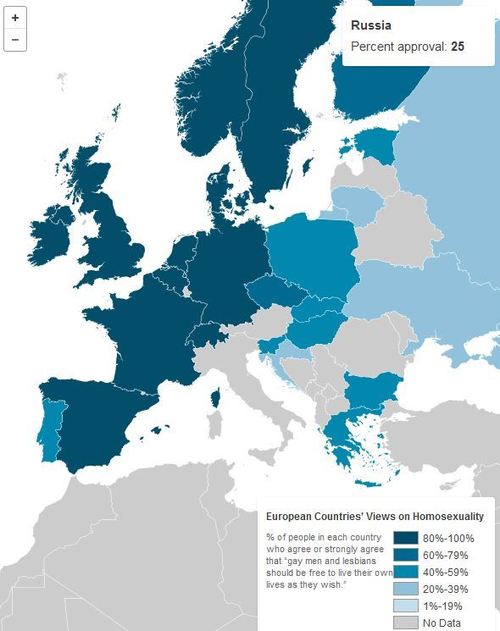
“A sampling of my 35 personal favorite posts of 2013. Enjoy!”

Seth Dixon‘s insight:

As we reflect on 2013 and prepare for 2014, I’ve compiled 35 post that were helpful to me in my classroom (see page 1 and page 2).  These are resources that I enjoyed curating or producing.  They might not be the best or the most important for your particular interests, but I look forward to continue curating this site and sharing valuable tidbits to geography educators in 2014.

See on www.scoop.it

Idaho’s the only state where a majority of adult households have no landlines

More adults in Idaho have embraced wireless life than have adults in any other state, according to new data from the Centers for Disease Control and Prevention.

Seth Dixon‘s insight:

Many associate wireless communications with the major metropolitan areas; this map and the data used to create it shows that rural states are more likely to abandon landlines. 

See on www.washingtonpost.com

Santas Around the World

This story map was created with the Esri Map Tour application in ArcGIS Online.

Seth Dixon‘s insight:

This story map shows some of the historical and regional differences in Santa Claus, as well as the cultural diffusion.  Merry Christmas to those that celebrate it and a Happy New Year to all. 

See on esripm.maps.arcgis.com

This Map Shows Why The Battle For ‘Ukraine’s Soul’ Is So Pivotal

The tug-of-war for Ukraine.

Seth Dixon‘s insight:

Strategically, Ukraine matters much more to Russia than it doesn’t the EU, which is why Russia is flexing there muscles.  Russia’s major market for their natural gas are linked through these key pipelines.  

See on www.businessinsider.com

Income inequality seen in satellite images from Google Earth

Nice visual on differences in income, with associated paper.  No stats needed here; a simple exploratory/observational curiosity is all you need.  A great starter for classroom discussions/lab activities. Start with this primer where you can see the distinct difference.

Seth Dixon‘s insight:

I certainly wouldn’t argue that trees create economic inequality, but there appears to be a strong correlation in between high income neighborhoods and large mature trees in cities throughout the world (see a scholarly reference from the Journal, Landscape and Urban Planning). Why is there such a connection? In terms of landscape analysis, what does this say about those who have created these environments? Why do societies value trees in cities? How does the presence of trees change the sense of place of a particular neighborhood? Click here for more Google images that show the correlation between income and trees.

See on flowingdata.com

How Many Earth-like planets are out there?

“Astronomers using NASA data have calculated for the first time that in our galaxy alone, there are at least 8.8 billion stars with Earth-size planets in the habitable temperature zone.  For perspective, that’s more Earth-like planets than there are people on Earth.”

Seth Dixon‘s insight:

I was recently flying over New York City and I was stunned at the vastness of this metropolis and amazed at the arrogance we take when we assume we ‘understand’ a place with millions of people and complex networks.  The geographic enterprise is remarkably ambitious and even if we can’t fully understand everything about our planet, we strive towards that goal…then I read this article and the magnitude of the universe simultaneously overwhelmed and inspired me.  8.8 billion earth-like planets!!  The only reason anyone could ever be bored is if they have stopped being curious about all that surrounds us.  

See on www.nbcnews.com

Maps and the Geospatial Revolution

Seth Dixon‘s insight:

This online course, Maps and the Geospatial Revolution, is designed to be an easy on-ramp to 21st century geospatial tools and any geography teacher hoping to modernize their skillset would do well to take this course (beginning April 30th) offered freely from the Program of Online Geospatial Education at Penn State, taught by Dr. Anthony Robinson.


Tags: GIS, teacher training, mapping, cartography, geospatial, edtech, geography education, unit 1 GeoPrinciples.

See on www.youtube.com

Geospatial

Climate Change at it’s most basic

http://www.HowGlobalWarmingWorks.org University of California

Seth Dixon‘s insight:

This NPR article highlighted this video and research that shows that a basic understanding of climate change is missing in our society (which opens up room for naysayers to think that all opinions are equally valid in a scientific discussion).

Eastern and Western Europe divided over gay marriage, homosexuality

Recent developments in Croatia and Scotland highlight a stark divide between Eastern and Western Europe on the topic of same-sex marriage.

Seth Dixon‘s insight:

Regions are fluid constructs that we use to think about places.  The region that we think of today as “Latin America” would not have been a discrete region 600 years ago since historical events have shaped the geographic evolution of the attributes of the region and the borders of world regions will continue to be redrawn.  Some have recently argued that since the end of the Cold War, the monikers Eastern and Western Europe are less meaningful in an economic context.   This map shows this old division can still be seen in this cultural/political context.  Some have argued that Russia’s recent move against gay rights is a geopolitical strategy to differentiate themselves from the West. 

TagsEurope, regions.

See on www.pewresearch.org

Blog at WordPress.com.

Up ↑