Houston is blessed by topography and geography. But the city’s recent success is really a masterclass in learning from history.
Seth Dixon‘s insight:
See on www.theatlantic.com
Houston is blessed by topography and geography. But the city’s recent success is really a masterclass in learning from history.
See on www.theatlantic.com
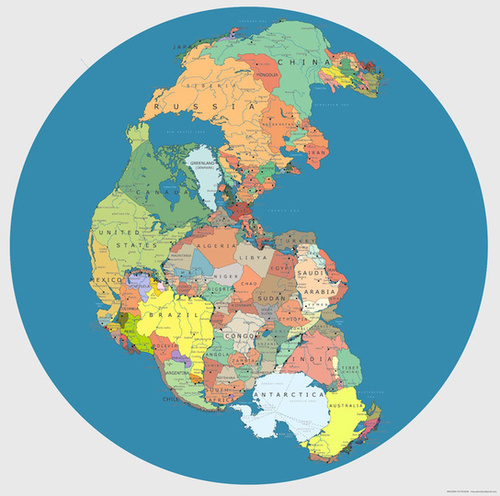
Pretty wild, right? It’s a map of Pangea — a supercontinent that formed roughly 300 million years ago — mapped with contemporary geopolitical borders.
See on io9.com
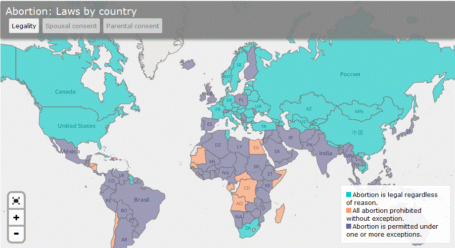
The complete global map of laws governing abortion and birth control.
This series of maps shows the cultural and legal differences around the world that impact access to abortion and birth control.
See on www.slate.com
In this interview with Rosemary Wardley (senior GIS cartographer at National Geographic Maps) she offers tips on how to evaluate the landscape to do well on the game, GeoGuessr. If you haven’t played GeoGuessr, you’ve got to try it out. It displays 5 locations in GoogleMaps StreetView and you have to guess where the images are located. You can pan and zoom in the StreetView to explore the landscape and find more context clues as to where that location is. It’s a fantastic exploration exercise.
See on www.slate.com
An innovative campaign to move “home-less people into people-less homes.”
Chicago’s poorer neighborhoods have experienced a severe decline as homes are being foreclosed at an alarming rate (62,000 vacant properties in Chicago and 40% of the homes underwater on the South and West Sides). When sections of a neighborhood are left vacant or in disrepair, it can have a lead to negative impacts on the community. To combat both the homelessness issue and the vacant home problem at the same time, “Cook County now plans to form what will become the nation’s largest land bank, an entity that will acquire thousands of vacant residences, demolishing some, turning others into much-needed rentals and holding onto others until they can be released, strategically, back into the market.”
Tags: Chicago, housing, urban, economic, poverty, place, socioeconomic, neighborhood.
See on www.nytimes.com
For centuries, civilization has focused on using maps as a form of communication. To lead you down a rabbit hole, I was curious on famous cartographers, and in…
See on www.govloop.com
“This case study examines the challenges of human well-being and urbanization, especially in the megacity of Jakarta.”
Megacities are growing, especially in the developing world. This rapid population growth leads to serious strains on many resources and the infrastructural capacities which leads to some dismal living conditions among the urban poor. World Vision Australia works to assist and empower many of those without access to these important amenities. Download the lesson as a PDF here.
Tags: Indonesia, urban, megacities, sustainability, development.
See on www.youtube.com
“Technology is reshaping our economic geography, but there’s disagreement as to how. Much of the media and pundits like Richard Florida assert that the tech revolution is bound to be centralized in the dense, often ‘hip’ places where ‘smart’ people cluster.
From 2001 to 2012, STEM employment actually was essentially flat in the San Francisco and Boston regions and declined 12.6% in San Jose. The country’s three largest mega regions — Chicago, New York and Los Angeles — all lost tech jobs over the past decade. In contrast, double-digit rate expansions of tech employment have occurred in lower-density metro areas such as Austin, Texas; Raleigh, N.C.; Columbus, Ohio; Houston and Salt Lake City. Indeed, among the larger established tech regions, the only real winners have been Seattle, with its diversified and heavily suburbanized economy, and greater Washington, D.C., the parasitical beneficiary of an ever-expanding federal power, where the number of STEM jobs grew 21% from 2001 to 2012, better than any other of the 51 largest U.S. metropolitan statistical areas over that period.” Read more.
See on www.newgeography.com
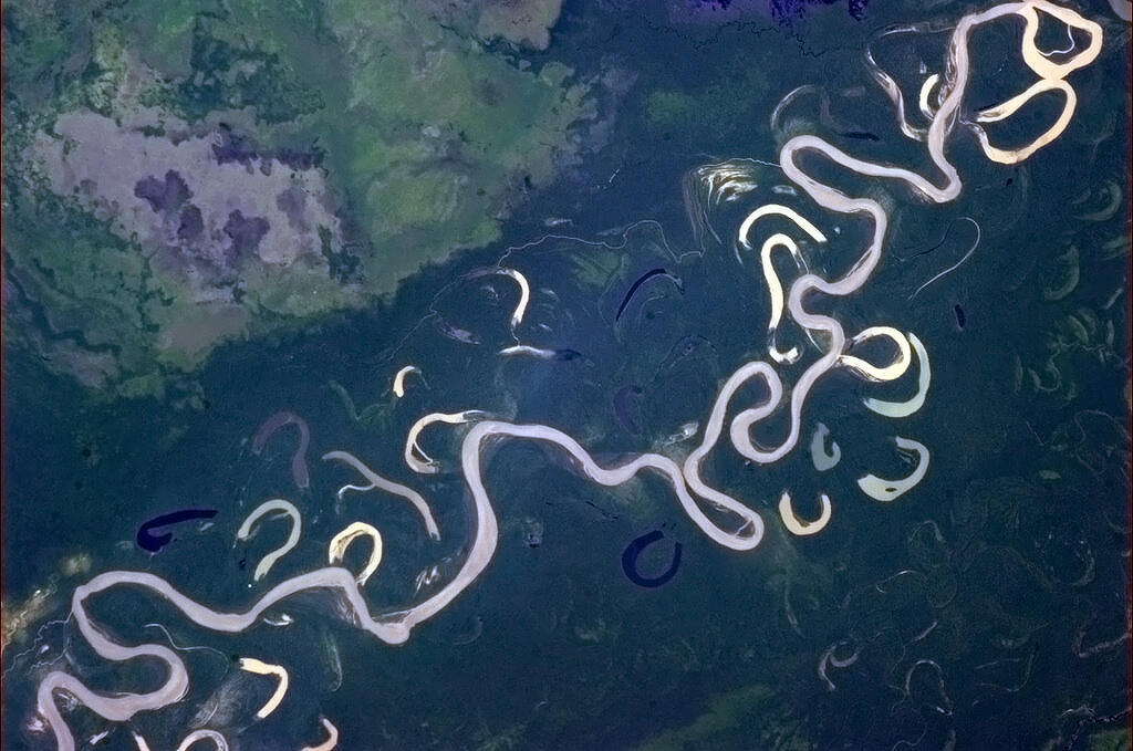
“I’m used to rivers that know what they’re doing.”
This incredible image clearly demonstrates the fluvial processes that have creating and this and will continue to reshape this landscape. Meander scars, oxbow lakes, channel cutoffs, floodplains and point bars are all here in this gorgeous teaching image.
Tags: physical, fluvial,geomorphology, erosion, landscape.
Even though Chris Hadfield’s time on the space station is over, his twitter stream can still be a great source of images displaying the physical and human landscapes (and if you needed any more evidence that he’s the coolest astronaut ever, watch his parting video singing David Bowie’s Space Oddity).
See on twitter.com