Search

GEOGRAPHY EDUCATION

Supporting geography educators everywhere with current digital resources.

Category

Uncategorized

States With Most and Least Stress

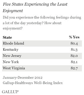
“For the past five years, Hawaii has consistently ranked as the least stressed state, while West Virginia, Kentucky, and Utah have been among the most stressed states. Despite this, Utah residents join Hawaii residents in reporting among the highest levels of enjoyment in the U.S., while West Virginia and Kentucky residents report some of the lowest levels of enjoyment.  While the relationship between stress and enjoyment is not clear, states with the highest stress levels tend to report less daily enjoyment.”

Seth Dixon‘s insight:

In addition to being the state with the least joy, Rhode Island is ranked as the 2nd most stressed out state.  I think that means it’s time to to get out of the Ocean State for a while. 

Questions to Ponder: what are some factors that may account for this regional variation?  What explains your states relative levels of stress and enjoyment?   

See on www.gallup.com

Global flight paths

Transportation planner plots pattern of airline travel across the globe.

Seth Dixon‘s insight:

This set of 9 images displays 58,000 flight paths from various perspectives.  What patterns do you see emerging from as you are able to visualize this data?  What does this tell you about the world today?

Tags: visualization, transportation, statistics,  globalization, mapping.

See on www.bbc.co.uk

Schools downplaying geography lessons

The Daily Rundown’s Chuck Todd takes a look at the National Geographic Bee and talks with host of the bee and of Jeopardy, Alex Trebek. Trebeck tells Todd that Americans are woefully ignorant when it comes to geography.

Seth Dixon‘s insight:

I know some people who aren’t huge fans of the geography bee because they feel that the format reinforces the stereotype that geography is about memorizing encyclopedic facts about places (I support the Bee in part because of the tremendous visibility it give for geography on a yearly basis).  While many of the questions do follow that format, that is primarily because it is structured for the elementary and middle school grades.  In high school and college, geography education draws on that ‘fact-based’ knowledge set about places and fosters spatial thinking skills which our labor force lack.  This video reminds of the current state of affairs, but I’m glad to see this conversation being had in the media.   

See on video.msnbc.msn.com

Top Ideas for Geography Teachers

The GA supports primary and secondary geography teachers through teaching resources, geography journals, CPD events, Barnaby Bear, Worldwise and more.

Seth Dixon‘s insight:

The Geographical Association (American reader can think of the GA as the UK version of the NCGE) is preparing for the end of the school year by preparing resources for geography teachers.

See on geography.org.uk

The Conflict Zone

“In a new series of four eight-minute videos, National Geographic Emerging Explorer Aziz Abu Sarah is a cultural educator working to build relationships between Israelis and Palestinians in Jerusalem and throughout Israel. In this series of four eight-minute videos, Abu Sarah meets with people from both sides of the conflict in order to better understand and communicate how this international dispute impacts their everyday lives.”

Seth Dixon‘s insight:

See on education.nationalgeographic.com

Finding the Hidden Faces in Google Maps – The Atlantic Cities

The Atlantic Cities Finding the Hidden Faces in Google Maps The Atlantic Cities And they’ve found many more faces, too – because they’ve actually built a computer program that sifts through Google Maps with facial-recognition technology to find…

See on www.theatlanticcities.com

Moore, OK: Before and After Imagery

Click here to edit the title

Seth Dixon‘s insight:

This interactive feature includes before and after satellite imagery of Moore, Oklahoma.  With the remarkably desvasting tornado that hit this week, this is an user-friendly way to compare before and after images by using the swipe function.


Tags: remote sensing disasters, environment, geospatial, esri.

See on tmappsevents.esri.com

Middle Earth: Why We Need to Turn Our Map on Its Side

Though he never actually crossed it, the Greek mathematician Pythagoras is sometimes credited with having first conceived of the Equator, calculating its location on the Earth’s sphere more than four centuries before the birth of Christ.

Seth Dixon‘s insight:

This is an interesting article on some Earth-Sun relationships that challenges the dominant north-centered normative view of how to think about our planet.  My favorite tidbit of information: “The velocity of the Earth’s rotation varies depending on where you stand: 1,000 mph at the Equator versus almost zero at the poles. That means that the fastest sunrises and sunsets on the planet occur on the Equator, and centrifugal and inertial forces are also much greater there. “

See on gizmodo.com

A parched Syria turned to war, scholar says, and Egypt may be next

Prof. Arnon Sofer sets out the link between drought, Assad’s civil war, and the wider strains in the Middle East; Jordan and Gaza are also in deep trouble, he warns

Seth Dixon‘s insight:

This is an interesting article; some seem the linkages that he is making between population growth and drought with war and conflict as being environmentally deterministic while others think that it is appropriately taking the geographic factors into consideration.  Conflicts over water can erupt, but how much of the conflict can be attributed these factors?  What do you think? 

Tags: SyriaMiddleEast, conflict, political, water, environment,

See on www.timesofisrael.com

Blog at WordPress.com.

Up ↑