“London-based design firm BERG created these two 3D maps of Manhattan, which look like a scene out of “Inception” (via Curbed NY).”
See on www.businessinsider.com
“London-based design firm BERG created these two 3D maps of Manhattan, which look like a scene out of “Inception” (via Curbed NY).”
See on www.businessinsider.com
GeoGuessr is a geography game which takes you on a journey around the world and challenges your ability to recognize your surroundings.
When I was a child I used to wonder if woke up somewhere far from home, would I be able to know where I was just by looking at the places around me (I was a geo-geek from way back when). GeoGuessr is the closest thing to finding yourself lost in the world and needing to figure out where you are without being wisked away. GeoGuessr will display 5 locations in GoogleMaps “StreetView” and you have to guess where the images are located. You can pan and zoom in the StreetView to explore the landscape and find more context clues as to where that location is. It is a fantastic exploration exercise.
See on www.geoguessr.com
“In April, the Associated Press decided the word ‘illegal’ should only be used to describe actions, not people. It’s one of several major news outlets that have been reconsidering how to refer to people who are in this country illegally.”
Tags: migration, ethnicity, race, population, podcast.
See on www.npr.org
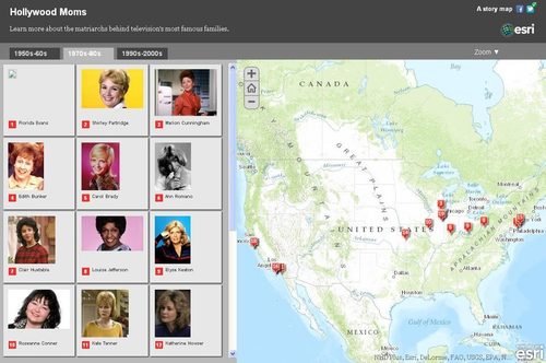
Famous TV Moms and where they lived. Happy Mother’s Day.
Today (May 10th) is Mother’s Day in Mexico and some other Latin American countries so what better time to share this map of TV Moms? Additionally, here are maps that display the various dates that different societies use to honor Mothers and Fathers.
Questions to Ponder: Many societies celebrate Mother’s Day around the vernal equinox and Father’s Day near the summer solstice. Is this a coincidence or are their some gendered messages in these cultural celebrations?
See on mediamaps.esri.com
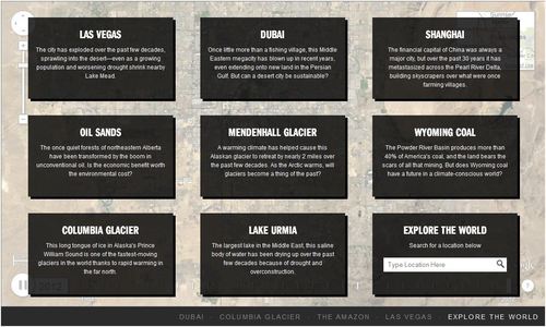
Exclusive timelapse: See climate change, deforestation and urban sprawl unfold as Earth evolves over 30 years.
This interactive feature includes various places that have experienced rapid environmental change in the last few decades. This is a simple way to show the power of remotely sensed data as well as massive environmental impact of rapid urbanization and globalization.
Tags: remote sensing, land use, environment, geospatial, environment modify, urban ecology.
See on world.time.com
Investigate for yourself the mechanisms of global trade
This more clearly shows the regional restructuring of the global economy than just about anything I’ve ever seen, especially manufacturing. The 8 largest and busiets ports in the world are all in East or Southeast Asia (and 11 of the top 13). A quick glance at the historical charts will show that most of these were relatively minor ports that have exploded in the last 20 years.
Tags: transportation, globalization, diffusion, East Asia, industry, economic.
See on www.smithsonianmag.com
For decades, south Louisiana residents have watched coastal landmarks disappear as erosion worsened and the Gulf of Mexico marched steadily inward.
See on www.houmatoday.com
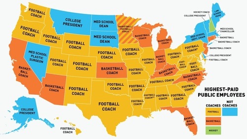
You may have heard that the highest-paid employee in each state is usually the football coach at the largest state school. This is actually a gross mischaracterization: Sometimes it is the basketball coach.
See on deadspin.com
This podcast explains the MOOC Maps and the Geospatial Revolution. It is designed to be an easy on-ramp to 21st century geospatial tools and any geography teacher hoping to modernize their skillset would do well to take this summer course from the Program of Online Geospatial Education at Penn State, taught by Dr. Anthony Robinson. Click here to register for free.
Tags: GIS, teacher training, mapping, cartography, geospatial, edtech, geography education, unit 1 GeoPrinciples.
See on twitter.com