Search

GEOGRAPHY EDUCATION

Supporting geography educators everywhere with current digital resources.

Category

Uncategorized

A Photo Essay on School Sprawl

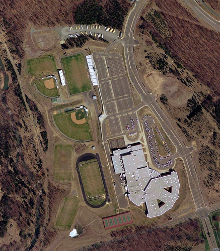
“Schools used to be the heart of a neighborhood or community. Children and not a few teachers could walk to class, or to the playground or ball field on the weekend. This was relatively easy to do, because the schools were placed within, not separated from, their neighborhoods. They were human-scaled and their architecture was not just utilitarian, but signaled their importance in the community. Now it has become hard to tell one from a Walmart or Target.”

What better way to demonstrate the concepts of urban sprawl, automobile-dependent city planning and economies of scale than by analyzing the very geographic context of our schools themselves?  This is a very nicely arranged photo essay that most could spark conversation and would foster some discussion on how best to plan neighborhoods and spatially arrange the city.

Tags: transportation, planning, sprawl, education, scale.

See on switchboard.nrdc.org

Getting to know the world around us

I was finishing up my recent vacation to Finland , with one day in Helsinki visiting friends, when a novel thought for many Americans occurred to me: Look at a map.

This article explains the importance of geography education, and how a lack of geographic understanding limits students and professionals.  While this is nothing new to this particular audience; however it is another tool to use to convince administrators and politicians that geography education needs to be stregthened in this era of increased global connectivity.

Tags: GeographyEducation, geo-inspiration, globalization

See on www.chicagotribune.com

Pigskin Geography

Pigskin Geography is a 17-week program that motivates students to learn United States geography by tracking the travels of competing professional football teams with the NFL schedule.

Pigskin Geography is an incredibly dynamic way to teach the geography of the United States. Specifically tailored for 4-6 grade students, this program gives students a series of 17 weekly activities that are adapted to the NFL schedule that week. These questions do NOT rely on football knowledge, but uses this as an opportunity to introduce vocabulary teams, and explore other places. For example: “This week the New Orleans Saints will ‘march’ over Cairo, IL, going to their game in Green Bay, WI. Locate Cairo at the southern end of the Illinois. Cairo is located at the CONFLUENCE of the _______ River and the _________________River.”

Tags: USA, sport, K12, geography, GeographyEducation, training.

See on www.pigskingeography.com

Tour the States – Music Video

Full album: http://www.marblesthebrainstore.com/brain-beats Music by Renald Francoeur Drawing by Craighton Berman “Tour the States” is track #1 from Brain Beats, a mnemonic CD…

It’s so often stated that geography education is so much more than just learning states and capitals. I wholeheartedly endorse that sentiment, but there is still some rudimentary importance to learning about where places are. I see it as analogous for English majors needing to learn basic grammar. You can’t write a masterpiece if you are still fumbling around with the alphabet. In geography, we can’t have a nuanced discussion of place and interconnectedness if we have no sense of where any place actually is.

Tags: USA, K12, video, GeographyEducation.

See on www.youtube.com

Street View goes underwater

Amazing things about Google Earth – news, features, tips, technology, and applications…

I wasn’t planning on an ocean mapping portion of my class today, but this new development changes that. 

Tags: water, biogeography, mapping, google.

See on www.gearthblog.com

Amazing view of Universe captured

The Hubble Space Telescope has produced one of its most extraordinary views of the Universe to date.

The Earth is an amazing place to study…but this makes it feel remarkably small. 

Tags: geospatial, space, remote sensing, scale, perspective

See on www.bbc.co.uk

The Living Bridge


In North East India just north of Bangladesh is the province of Meghalaya.

This is an astounding video that shows a (literally) natural way that local people have adapted to an incredibly flood-prone environment to prevent erosion and to keep people in contact during times of flood.  The living bridges are truly a sight to behold.

Tags: environment, environment adapt, SouthAsia, water, weather climate, indigenous,

See on www.youtube.com

Urban Agriculture Sprouts in Brazil’s Favelas

Urban Agriculture Sprouts in Brazil’s Favelas – Organic agriculture is a growing trend in big cities around the world, including Latin America, and no…

This article nicely ties two commonly taught issues in human geography that aren’t the the typical combination: 1) the growth of organic farming and 2) the spread of squatter settlements and slums in the developing world. 

Tags: agriculture, food, urban, unit 5 agriculture, unit 7 cities

See on www.ipsnews.net

Spatial Thinking Key to Solving Crime

What are all these news reporters and school administrators doing in my classroom?  Monday, September 24, 2012 was most certainly an interesting day in my Mapping Our Changing World (GEOG 201) class…

One of my students applied some mapping skills and spatial analysis to a string of unsolved bank robberies in Rhode Island.  After 7 months of eluding capture with at least 8 robberies under his belt, the “bearded bandit” was aprehended less then 48 hours after my student handed over his analysis to a contact in the police department.  Coincidence?  I think not!  Great work Nic, showing that spatial thinking and geographic skills can be applied to a wide range of disciplines and activities.


Tags: RhodeIsland, GIS, mapping, GeographyEducation, edtech.   

See on geographyeducation.org

Blog at WordPress.com.

Up ↑