This is not nice, but it is still very funny.
Tags: mapping, NYC, cartography.
See on www.madmagazine.com
This is not nice, but it is still very funny.
Tags: mapping, NYC, cartography.
See on www.madmagazine.com
Hiking to the top of Preikestolen (the Pulpit Rock) near Stavanger, Norway. An amazing and wondrous hike.
For the inner explorer in all of us, this is a geographic dream. Click here to read more about this fantastic climb from a National Geographic explorer.
Tags: Europe, landforms, NationalGeographic.
See on www.youtube.com
Do you want some inspiration to create a visually stunning – yet fully optimized – data graphic? Well, let’s go back about a 140 years… Handsome Atlas developed by Jonathan Soma of Brooklyn Brainery, provides a stunning new online interface to a large collection of beautiful data visualizations from the 19th century.
TR: Taking into account the age of these visualizations, one has to wonder if they intended them to be used by our generation in this way. I see potential for a “web 2.0” update of these charts to make them interactive . . .
Tags: infographic, historical, visualization, statistics.
See on infosthetics.com
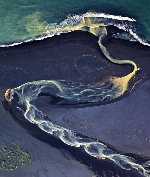
Time and time again, we’re reminded of nature’s beauty. It’s hard to believe, but these photos of real landscapes, not abstract paintings.
Andre Ermolaev, through his photography has captured the beauty of Iceland’s geomorphology. Being on the Mid-Atlantic Ridge, Iceland has abundant volcanic ash which adds rich color to the fluvial systems.
Tags: geomorphology, physical, Europe, fluvial, water, landforms, images.
See on www.mymodernmet.com

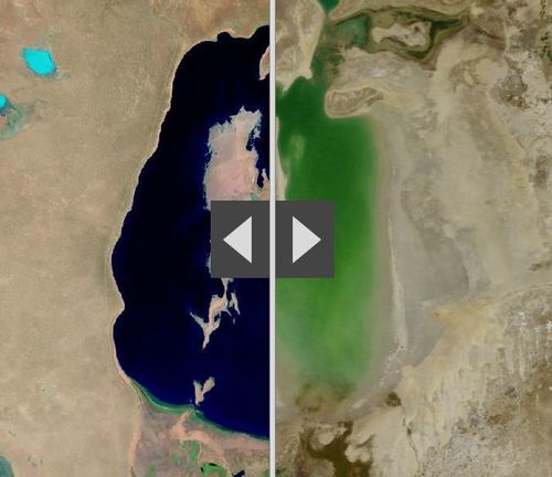
By moving the slider, the user can compare 1990 false-color Landsat views (left) with recent true-color imagery (right). Humans are increasingly transforming Earth’s surface—through direct activities such as farming, mining, and building, and indirectly by altering its climate.
This interactive feature includes 12 places that have experienced significant change since 1990. This is an user-friendly way to compare remote sensing images over time. Pictured above is the Aral Sea, which is and under-the-radar environmental catastrophe in Central Asia that has its roots in the Soviet era’s (mis)management policies.
Tags: remote sensing, land use, environment, geospatial, environment modify, esri, unit 1 Geoprinciples, zbestofzbest.
See on storymaps.esri.com
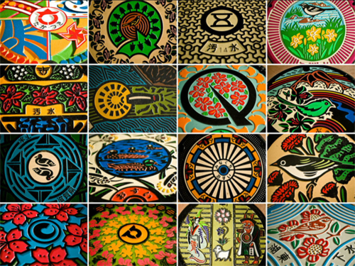
Manhole covers are ubiquitous in the modern urban fabric; they are typically drab and purely utilitarian. In Japan, municipalities take pride in the this ordinary piece of the landscape and convert them into extraordinary works of art that reflect the local people, place and culture.
Tags: book review, landscape, art, urban, culture, place, EastAsia.
See on www.gwarlingo.com

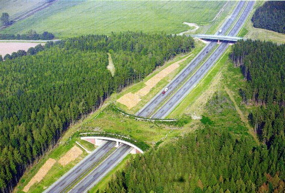
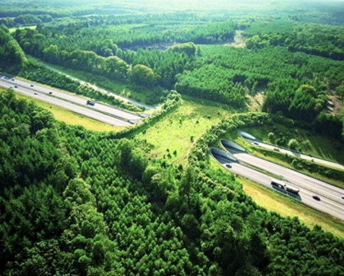
Our modern society depends on greater connectivity between places. Regionalized economies, politics and transportation networks are increasingly integrated with far-flung places now more than ever before. Our biosphere and natural environments are exceptions to this pattern. Wilderness areas are ‘islands’ in an ocean of human controlled environments. We create transportation linkages that unite people economies and cities, but separate herds from there extended habitat.
We’ve all seen road kill on major highways. Species like deer, elk, and grizzly bears and other large-bodied animals need a wide range for numerous ecological reasons. These bridges are an attempt to ameliorate some of the problems that our roads pose for the non-human species that still call Earth home. From a purely economic standpoint, many argue that these bridges save society money given the accidents and property damage that can be avoided.
Tags: biogeography, transportation, environment, land use, sustainability, environment adapt.
See on www.theworldgeography.com
UPDATE: and here is a painful/hilarious video of someone who clearly doesn’t understand these principles.
Afghan troops are told that insulting behavior by Americans is an oversight, not a slight.
Cross-cultural interactions can be beautiful when immersed into a new cultural setting and the visitor learns to appreciate it. Unfortunately, it can often lead to clumsy missteps that are born out of ignorance of a new guiding set of cultural norms. Some missteps can lead to great laughter while others can be gravely insulting. The United States military seeks to train U.S. soldiers about Afghan customs, but they are trying a new tactic as well to minimize these issues. The U.S. military has prepared a cultural guide to teach the Afghan soldier that they work with about the curious customs that are part of social interaction in the United States but not considered offensive.
Tags: culture, war, unit 3 culture, conflict.
See on www.washingtonpost.com
“We are extremely sorry,” Apple CEO Tim Cook says in an open letter.
Producing a poor map can have disastrous consequences, especially if that map is widely disseminated. Given that people rely on maps to be accurate and base decisions on spatial information, it is the mapmaker’s responsibility to not go live with a map (or mapping platform) until it does meet the standards of expectation.
Tags: mapping, technology.
See on www.theatlantic.com