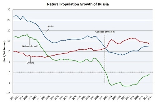
Search

GEOGRAPHY EDUCATION

Supporting geography educators everywhere with current digital resources.

Category

Uncategorized

MDG drinking water target being met is cause for celebration

Via Scoop.itGeography Education
Sanjay Wijesekera: This achievement shows that where there is a will, it is possible to truly transform the lives of hundreds of millions of people for the better.  

The MDG (Millennial Development Goal) to cut the global population that does not have access to clean drinking water was cut in half, and five years ahead of schedule. The World Health Organization and the United Nations are very pleased with this achievement, but it is a timely reminder of the developmental problems of poverty and access that still exist. For example, 783 million people still do not have access to clean drinking water.  3,000 children die each day from diarrheal diseases (usually from bad drinking water and poor sanitation). Although some success should be celebrated, the world, in the currently constituted social, economic and political framework, still does not provide the most basic of requirements for a sizable portion of humanity.
Via www.guardian.co.uk

Napoleonland: Return of the King

Via Scoop.itCultural Geography

“Nearly 200 years after his death, Napoleon Bonaparte is finally getting the greatest honor our age can bestow: his own theme park. Napoleonland — stop laughing — was concocted by a former French minister to rival Disneyland in its immersive fun and totemic cultural status. Shopping! Dining! Re-enactments of the Battle of Austerlitz! Not a bad rehabilitation for an all-conquering megalomaniacal exiled emperor.”

Culture and heritage are packaged in places such as theme parks as a commodity–what should we make of these spaces?  What do they say about the society that creates them?  What are the economic, cultural and political motives for creating such as space?
Via www.foreignpolicy.com

The Russian Cross

Via Scoop.itGeography Education

The economic and social turmoil after the fall of the Soviet Union was profound enough to be seen in the demographic statistics.  Birth rates dropped as the death rates went up.  Typically when birth rates drop it is presented as an indicator of social development, but it clearly is not in this instance.  What explains these statistics?
Via en.wikipedia.org

The Difference between the United Kingdom, Great Britain and England Explained

Via Scoop.itGeography Education

Via www.youtube.com

European Maps: Ethnolinguistics

Via Scoop.itGeography Education

This site houses several good maps, especially this one of the ‘core’ and ‘periphery’ of Europe. This map corresponds strongly with maps that show the first places to be industrialized. The Map on the formal culture regions is also especially useful for understanding cultural barriers to diffusion.  What is the connection between the branches of Christianity and Indo-European language families?  
Via www.nonformality.org

Europe according to Estonians

Via Scoop.itGeography Education

This video is not very educational, filled with bad stereotypes and some truly inaccurate (and potentially offensive) statements.  Still, I show it every semester as the rationale for why we need to study more about Europe (but mainly because my students LOVE watching it).    
Via www.youtube.com

Take Survey to aid USA Geography Education

Via Scoop.itGeography Education

“The American Geographical Society (AGS) needs your help in a matter of vital importance. We are conducting a nationwide survey of public attitudes toward geography and knowledge about geography. This is our part in a major study funded by the National Science Foundation. The only eligibility requirement is that you must be age 18 or older. The results will help guide Federal and state policies regarding geographic education.”  Please take the quiz but MORE IMPORTANTLY, get non-geographers (FB friends, twitter followers, etc.) to take the quiz.   
Via www.amergeog.org

What Doesn’t Stay in Vegas? Sprawl.

Via Scoop.itGeography Education

This NASA-produced timelapse video of Landsat data shows the spatial spread of the Las Vegas metropolitan area from 1975-2010.  These are not true color images, but false color that shows the near infrared portions of the electromagnetic spectrum as red in the image.  Geospatial technologies are once again, shown as invaluable in our analysis of the urban environment.   
Via www.flickr.com

What is Affordable Housing?

Via Scoop.itGeography Education

This is an excellent interactive map that allows the user to explore the various neighborhoods of New York City and analyze the housing market for a particular income bracket.  I’ve discovered that trying to purchase a home or rent an apartment can be one of the best hands-on lessons in urban social geography.  I envision a dynamic project that could be designed around this resource where several members of a group are given different demographic characteristics (for example: single income, 2 married adults, 3 children under 10 years of age) and income levels and a fixed workplace.  Where would you live?  What determines your choices?  What would your personal geographies look like?    
Via envisioningdevelopment.net

Create a free website or blog at WordPress.com.

Up ↑